
Background image taken at Hainault

1 October 1868
Bicycle Rack
Step free access from street to platform - see note below
2
Toilets are available Disabled and baby changing outside gate line
Car Park

No
Hackbridge railway station is a railway station at Hackbridge in the London Borough of Sutton in South London. The station is served by Southern and Thameslink. It is in Travelcard Zone 4.
The station platforms can accommodate up to 7 coaches. Where trains are longer than this, selective door opening is used. The National Rail information for this station can be here. Platforms are open air. For step free access to go from platform 2 to platform 1 and the booking office, you have to walk along a footpath, up to the main road, over the road bridge and then back pass the station and in through the car park. It is NOT a short distance!

Originally 26th September 1850 see below for more
Bicycle Rack
Car Park
Step free access from street to platform
2
No

Hackney Central is a London Overground station on the North London line in Hackney Central, Greater London. It lies between Dalston Kingsland and Homerton and is in Travelcard Zone 2. The station and all trains serving it are operated by National Rail (link to Wikipedia) services under the control of the London Rail division of Transport for London. However, there is no standard red National Rail "double arrow" logo signage at the station, instead only the Overground roundel. The National Rail station specific information can be found here.
The station is connected to Hackney Downs by a direct passenger walkway linking the two stations (replacing an earlier such link) that was opened in July 2015. This walkway means passengers do not have to exit on to the street in order to continue their onward journey.
The North London Railway opened a station named Hackney on 26 September 1850, to the east of Mare Street, then in the county of Middlesex. It closed on 1 December 1870 and was replaced the same day by a station to the west of Mare Street, designed by Edwin Henry Horne and also named Hackney, the station then closed in 1944 and reopened 12th May 1980. The platforms are open air.

27th May 1872
Bicycle Rack
4
No
No step
free access

Hackney Downs is a London Overground and National Rail station in Hackney Central and serves the old common land of Hackney Downs in Lower Clapton in the London Borough of Hackney, it is on the Lea Valley lines and West Anglia Main Line. It is 2 miles 78 chains (4.8 km) down the line from London Liverpool Street and has a direct passenger link to Hackney Central station, providing interchange with the North London line of the Overground network.
On the London Overground, Lea Valley Lines the station is between London Fields and either Clapton (on the Chingford branch) or Rectory Road (on the Cheshunt/Enfield Town branch). Main line trains, operated by Greater Anglia, call at Hackney Downs between Liverpool Street and Tottenham Hale. Its three-letter station code is HAC and it is in Travelcard zone 2.
The station was originally named Hackney Downs Junction until 1896.
The station was opened on 27 May 1872 when the Great Eastern Railway opened the first part of its new line from Enfield Town to Stoke Newington. The National Rail information about this station can be found here. The platforms here are open air.

12 May 1980 by
British Rail
2
Bicycle Rack
Step free access from street to platform

No
Hackney Wick is a station on the North London Line in the area of Hackney Wick, East London. It is in Travelcard Zone 2. The station and all trains serving it are operated by London Overground. It opened on 12 May 1980 by British Rail on the re-routed line which bypassed the site of the former Victoria Park station as part of the Cross Town Link line between North Woolwich and Camden Road stations.
This station was a key transport point for the 2012 Summer Olympics as it is situated 100 m (330 ft) from the western periphery of the Olympic Park. However, due to potential overcrowding, TfL announced that westbound trains would not stop at this station for the duration of the Games.
Between Spring 2017 and May 2018 the station was rebuilt and modernised, including replacement of the footbridge by a subway. The National Rail information about this station can be found here. The platforms are open air.

Original station 2nd September 1867
See below for more dates
Step free access
from street to train
2
Bicycle Rack
No

Haggerston is a station on the East London line in Haggerston within the London Borough of Hackney, Greater London. The station is located on the Kingsland Viaduct at the junction of Arbutus Street and Frederick Terrace, near Kingsland Road. The main entrance is in Lee Street. The station was built as part of the East London line extension served by National Rail London Overground under the control of the London Rail division of Transport for London, however there is no standard red National Rail "double arrow" logo signage located at the station, instead only the Overground roundel.
Services were withdrawn on 6th May 1940 as an economy measure during World War II and the following October the station building was badly damaged a bomb.The signal box was damaged by a further air raid in April 1941 and was not replaced. Although the station was closed, train services still passed through here until it was rebuilt and then reopened 27th April 2010.
The National Rail information for this station can be found here. The platforms here are open air.

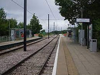
Hainault is a London Underground station in Hainault, east London, England. The station is on the Central line between Fairlop and Grange Hill stations. Since 2 January 2007 the station is in Travelcard Zone 4. This station is also home to one of the three Central line depots.
The station was opened on 1 May 1903 as part of the Great Eastern Railway's (GER) Fairlop Loop branch line from Woodford to Ilford. The line was designed to stimulate suburban growth but was closed on 1 October 1908 due to a lack of custom and did not reopen until 2 March 1930. Platforms are open air and there is a Maintenance depot here. Some services do terminate/start from here, but the lines do run through the station. More photos can be seen at: https://tubemapper.com/hainault-station/
District & Piccadilly
Bicycle Rack
Main Entrance leads through a small
shopping centre
9th September 1874
by the District Railway
4
Step free access from street to platform
No


Hammersmith is a London Underground station in Hammersmith. It is on the District line between Barons Court and Ravenscourt Park, and on the Piccadilly line between Barons Court and Acton Town or Turnham Green at very early morning and late evening hours. The station is in Travelcard Zone 2.
The Hammersmith & City line's and Circle line's station of the same name is a separate station to the north-west. The two stations are separated by Hammersmith Broadway.
The station was opened on 9 September 1874 by the District Railway (DR, now the District line) as the western terminus of the railway when it was extended from Earl's Court. On 4th July 1932 the Piccadilly West extension was opened. In the early 1990s, the station buildings were demolished along with the neighbouring bus garage and incorporated into a modern shopping centre and Underground and bus interchange. The platforms are in a cutting and the station has a high glass roof. If you wanted to get to the other Hammersmith station by train, it would require a minimum of 10 stops and 3 changes.
Hammersmith & City / Circle
13th June 1864 re-sited
1st December 1868
Coffee Shop
3
Step free access
from street to train

Yes

Hammersmith is a London Underground station in Hammersmith. It is the western terminus of the Circle and Hammersmith & City lines. The station is in Travelcard Zone 2 and is a short walk from the station of the same name on the Piccadilly and District lines. The two stations are separated by Hammersmith Broadway.
The Circle line has served Hammersmith since 13 December 2009. By June 2011 all of the platforms had been lengthened to accommodate the new and longer S7 Stock trains, that first entered service on the Hammersmith and City Line from the beginning of July 2012. These new trains are seven cars in length instead of the six cars of C Stock that previously operated.
The present station is situated on Beadon Road and opened on 1 December 1868, replacing the original station slightly north of here which opened on 13 June 1864 when the Metropolitan Railway's extension was built from Paddington. The platforms are partially covered with a high glass roof.
The Hammersmith depot is located just outside the station. It is used for general maintenance and storage of the S7 Stock trains which operate on the Hammersmith & City line. If you wanted to get to the other Hammersmith station by train, it would require a minimum of 10 stops and 3 changes.

Hampstead is a London Underground station in Hampstead, North London. It is on the Edgware branch of the Northern line, between Golders Green and Belsize Park stations. The branch's northernmost subterranean station, it is on the boundary between Travelcard Zone 2 and Zone 3. Designed by architect Leslie Green, it was opened on 22 June 1907 by the Charing Cross, Euston & Hampstead Railway. As it is at the junction of Heath Street and Hampstead High Street, the name Heath Street was proposed before opening, and the original tiled signs on the platform walls still read Heath Street. Because Hampstead is on a steep hill, the station's platforms are the deepest on the London Underground network, at 58.5 metres (192 ft) below ground level; and it has the deepest lift shaft on the Underground, at 55 metres (180 ft). The station layout can be seen here. If ever the lifts are is not working (still not totally step free), it is probably better to go to Belsize Park and walk, rather than attempting the 320 steps (about 18 storeys) which can be seen in this video!
There is also a great video by Geoff Marshall which explains the myth of the 15 (or maybe 18) storey signage here. Hampstead Heath station is about 1 mile away from here, so is not classed as an OSI
Bicycle Rack
2nd January 1860
2
Step free access
from street to platform
Coffee Shop
No

Hampstead Heath railway station is in the London Borough of Camden in north London on the North London Line, between Finchley Road & Frognal and Gospel Oak stations, and is in Travelcard Zone 2. Since 11 November 2007 it and the service there have been run by London Overground. The National Rail information for this station can be found here.
The platforms are open air, although in a cutting, so the entrance is on a road bridge across the tracks.
Hampstead Underground station is about 1 mile away from here, so is not classed as an OSI.


Hanger Lane is a London Underground station in Hanger Hill, Ealing, on the border between West and Northwest London. It is located on the West Ruislip branch of the Central line, between Perivale and North Acton stations, and is in Travelcard Zone 3.
It is about a 10 minute walk of Park Royal station on the Piccadilly line. The two lines cross a little east of Hanger Lane station.
The Great Western Railway (GWR) opened Twyford Abbey Halt just east of the site on 1 May 1904 as part of the GWR and Great Central Railway Joint Railway project (the New North Main Line) towards High Wycombe. It was closed on 1 May 1911, replaced by Brentham station to the west of the present location. The platforms are open air, although in a cutting so the entrance and roof of the subsurface ticket hall form the centre of the Hanger Lane Gyratory System, which was built after the station was built, so access is via a subway.

1st December 1838 by the Great Western Railway
Bicycle Rack
Step free access from street to platform
Toilets accessible outside ticket gate line
(Male & Female)
3 - 1 island and 1 side
24th May 2022 became Elizabeth line
No

Hanwell railway station serves Hanwell in the London Borough of Ealing. It is 7 miles 28 chains (11.8 km) down the line from London Paddington and is situated between West Ealing and Southall.
The station is on the original line of the Great Western Railway which opened on 4 June 1838, although Hanwell station was not ready until December of that year; it opened on 1 December. From 1 March 1883, the station was served by District Railway services running between Mansion House and Windsor; the service was discontinued as uneconomic after 30 September 1885. The station was renamed Hanwell and Elthorne on 1 April 1896, and reverted to Hanwell on 6 May 1974. Re-built circa 1875–77 some 250m east of its original location at the time the main line was quadrupled, it has been declared a grade II listed building by English Heritage.
The National Rail information for this station can be found here.

16th April 1917
- Bakerloo services
Bicycle Rack
2 - shared with
both services
No step
free access
15th June 1912 by the London and North Western Railway

No
Harlesden is a Network Rail station on Acton Lane in northwest London, served by London Overground and by London Underground Bakerloo line trains. The railway line here is the border between the Harlesden and Stonebridge residential area in the east, and the Park Royal industrial estate to the west.
The first station at the site was Willesden which was opened in 1841 by the London and Birmingham Railway and closed in 1866, replaced by Willesden Junction station, 0.5 miles (0.80 km) to the south east. In the Watford DC Line program of new electrified suburban tracks of the London and North Western Railway, a new station, "Harlesden", opened on 15 June 1912. Bakerloo line services on the same tracks began on 16 April 1917, via a new junction at Queens Park station. The Watford Junction to Euston modernisation project was completed in 1922. The National Rail information about this station can be found here. The platforms here are open air.
1st December 1868
Step free access from street to platform
Bicycle Rack
Toilets accessible inside ticket gate line
(Male & Female & Disabled)
4
24th May 2022 - Elizabeth line

No
Harold Wood railway station is on the Great Eastern Main Line in east London, serving the Harold Wood area of Romford in the London Borough of Havering. It is 14 miles 76 chains (24.1 km) down the line from London Liverpool Street and is situated between Gidea Park and Brentwood. Its three-letter station code is HRO and it is in Travelcard zone 6.
Harold Wood station was opened on 1 December 1868 by the Great Eastern Railway on its main line from Bishopsgate
The National Rail information about this station can be found here. The platforms here are open air. Ownership was transferred to the Elizabeth line on 24th May 2022
Bicycle Rack
1st June 1880
2
Step free access from street to platform

No
Harringay Green Lanes railway station is on the Gospel Oak to Barking line in Harringay, north London. It is 4 miles 61 chains (7.7 km) from St Pancras (measured via Kentish Town and Mortimer Street Junction) and is situated between Crouch Hill and South Tottenham.
The National Rail information about this station can be found here. The platforms here are open air.

None - just residential and a cemetery
11th May 2000
Step free access
from street to tram
2
No
Harrington Road tram stop is a light rail stop in South Norwood in the London Borough of Croydon in the southern suburbs of London. Harrington Road is in a residential area, and along with Woodside tram stop is the nearest tram stop to the town of South Norwood. Beckenham Cemetery lies immediately to the east and there is an entrance immediately adjacent to the tramstop.
The tram stop, which is served by Tramlink, connects to central Croydon. The stop is at ground level on double track, with platforms on each side of the track.
20th July 1837 by the London and Birmingham Railway
Bicycle Rack
Toilets accessible outside ticket gate line
(Male & Female & Disabled)
6 (plus
1 abandoned)
Car Park
Coffee Bar
Newsagent
Step free access from street to platform
16th April 1917 - Bakerloo

Yes for Bakerloo
Harrow & Wealdstone is a London Underground and railway station on the Watford DC line and West Coast Main Line in Harrow and Wealdstone in the London Borough of Harrow. It is 11 miles 30 chains (18.31 km) on the line from London Euston station. It is also the northern terminus of the Bakerloo line following Kenton.
It is served by London Underground (Bakerloo line), London Overground, London Northwestern Railway, and Southern services. The station is located between The Bridge (which joins the southern end of High Street) and Sandridge Close, with entrances leading to both. It is one of the oldest stations in the London region in existence.
The Harrow and Wealdstone rail crash of 1952, which killed 112 people, occurred at the station. It remains Britain's worst peacetime rail disaster. The National Rail information about this station can be found here and the platforms are open air, unlike other stations further along the line, the tracks are not shared between the Overground and the Underground.
The station was opened by the London and Birmingham Railway (L&BR) as Harrow on 20 July 1837 (which is older than the first section on the Underground opened by the Metropolitan Railway) and is now a listed building.
There is an abandoned platform here from where services used to run to Stanmore Village

One of the mixed size typeface roundels
Bicycle Rack
2nd August 1880 by the Metropolitan Railway
Step free access
from street to platform
6 - 2 are shared
with the Mainline
Car Park
Newsagent
Toilets accessible outside ticket gate line
(Male & Female)

No
Harrow-on-the-Hill is an interchange railway station in Harrow, served by suburban London Underground Metropolitan line services and commuter National Rail services on the London–Aylesbury line. It is 9 miles 18 chains (9.23 mi; 14.85 km) down the line from London Marylebone. Harrow-on-the-Hill is the final Metropolitan line stop from Central London before the line splits with the main branch towards Moor Park and the diverged Uxbridge branch towards Uxbridge. It is in Travelcard Zone 5.
The station was opened as "Harrow" on 2 August 1880, when the Metropolitan Railway was extended from its previous terminus at Willesden Green. Its name was changed to "Harrow-on-the-Hill" on 1 June 1894. The Great Central Railway (GCR) started operating services on 15 March 1899, which is now the National Rail services. The National Rail information about this station can be found here. The platforms are open air.
Bicycle Rack
Around 1843 by the London and Birmingham Railway
Step free access is only available on the Northbound platform
2
(plus 1 disused)
Car Park
Cafe
Mini Cab office

No
Hatch End is a railway station in the London Borough of Harrow, in north London, and in Travelcard Zone 6. London Underground's Bakerloo line trains served the station from 16 April 1917 until 24 September 1982. London Overground services on the Watford DC Line from London Euston currently serve this station.
The original station opened as Pinner on the London and Birmingham Railway, somewhere around 1843. It was renamed Pinner and Hatch End on 1 January 1897. The present station was built in 1911 to a design by architect Gerald Horsley, son of the painter John Calcott Horsley. The station was served by the Baker Street and Waterloo Railway (Bakerloo) from 16 April 1917, when Bakerloo services were extended from Willesden Junction to Watford Junction. The station was again renamed Hatch End (for Pinner) on 1 February 1920, and finally Hatch End on 11 June 1956. Bakerloo line services were withdrawn on 24 September 1982.
The National Rail information about this station can be found here. The platforms are open air.


Hatton Cross is a London Underground station on the Heathrow branch of the Piccadilly line. It is in Travelcard Zones 5 and 6 and stands between the Great South West Road (A30) and the Heathrow Airport Southern Perimeter Road.
The station opened on 19 July 1975 in the first phase of the extension of the Piccadilly line from Hounslow West to Heathrow Airport and it remained the terminus until Heathrow Central opened on 16 December 1977. The platforms are about 4.3 metres underground and were built using the cut and cover method. Although this station is at the end of the runway, it is not the place to catch a train to for catching a flight, but it is a good place to stop and watch planes. For anyone transferring to the airport with luggage, there is a shuttle bus service from outside the front of the station.The platform tiling on the central columns features patterns derived from the British Airways Speedbird logo.
This station is included in the free Heathrow to Heathrow interchange, which means that if you travel to here from any of the Heathrow stations, it is free.
Bicycle Rack
1st October 1868 by the London, Brighton and South Coast Railway
2
No
No step
free access
Parade of shops
within a short walk

Haydons Road railway station is in the north-east of the London Borough of Merton in South London. It is the nearest station to the Plough Lane stadium, the home ground of AFC Wimbledon.
The station is served by Thameslink trains and by a limited number of Southern services during the morning and evening peak. It is on the Sutton Loop Line and is in Travelcard Zone 3.
It was opened, originally as Haydens Lane, by the Tooting, Merton and Wimbledon Railway (itself jointly owned by the London and South Western Railway and the London, Brighton and South Coast Railway) on 1 October 1868. The National Rail information about this station can be found here. The platforms here are open air.
Bicycle Rack
Around 1865 as a mainline station
5
(1 is a terminus)
Step free access from street to platform
Some services do terminate here.
Toilets accessible outside ticket gate line
(Male & Female & Disabled)
24th May 2022 - Elizabeth line

Hayes & Harlington is a railway station serving the west London districts Hayes and Harlington in the London Borough of Hillingdon. It is 10 miles 71 chains (17.5 km; 10.89 mi) down the line from London Paddington and is situated between Southall and West Drayton.
It has long operated as a minor stop on the Great Western Main Line and is at the start of a spur to Heathrow Airport, to and from which passenger trains operate since the early 21st-century building of the spur which benefits from a flyover junction.
From 1 March 1883, the station (then named Hayes) was served by District Railway services running between Mansion House and Windsor (central). The service was discontinued as uneconomic on 30 September 1885.
The National Rail information can be found here. The platforms are open air.
Bicycle Rack
10th February 1913
2
No
No step
free access

Headstone Lane is a railway station near Headstone, in the London Borough of Harrow. The station is in Travelcard Zone 5.
The station was previously also served by the Bakerloo line of the London Underground between 16 April 1917 and 24 September 1982. The National Rail information about this station can be found here. The platforms are open air. This station used to be served by Silverlink
None for the station as it is linked underground to the main airport terminals
23rd June 1998 - Mainline
16th December 1977 - Piccadilly line
2 for the Elizabeth/Mainline
2 for the Piccadilly
Step free access from airport to train - all platforms


No
Platform sign on Piccadilly line
Platform sign on Elizabeth line
Someone could argue that both these signs are incorrect, as the Piccadilly one technically shouldn't have "Terminal 1" and the Elizabeth one probably shouldn't really have the word "Central".
There are 2 stations here which both serve London Heathrow Airport. Terminal 2 and Terminal 3 (and formerly Terminal 1 before its closure and replacement by Terminal 2 in 2015). They are both only accessed through the airport terminal, but they have separate entrances and cannot be directly accessed from each respective line, so check which service you require before going through the airport terminal.
The stations are situated in Travelcard Zone 6. Although neither of the stations have toilet facilities, there are some in and around the airport, along with various food/drink outlets. The layout of the tracks and platforms can be seen here.
The Elizabeth line (& Mainline services) part of the station still has the signs on the platform that say "Heathrow Central". These platforms are also served by Heathrow Express trains direct to central London. It is 14 miles 50 chains (23.5 km) down-line from London Paddington. This was opened 23rd June 1998. The National Rail information can be found here. The platforms are located under the runway of the airport. Transport for London Travelcards are not valid on Express services from this station, although they are valid on the Elizabeth Line. Passengers transferring between any of the terminals at Heathrow may use the trains free of charge.
The London Underground section is on the Heathrow branch of the Piccadilly line, The station was named Heathrow Terminals 1, 2, 3 until January 2016, when the station was renamed to coincide with the closure of Heathrow Terminal 1. Despite the renaming of the station, the signage on the platform as well as the announcements and signage in the trains still say Heathrow Terminals 1, 2, 3.
The station opened as Heathrow Central on 16 December 1977 as the final phase of the Piccadilly line's extension from Hounslow West to the airport. These platforms are about 14 metres underground and were dug under the airport whilst the airport was fully operational.
If you travel by train between any of the Heathrow stations, it is free to do. There is a video here, if you would like to see it.
1 for Piccadilly
2 for Elizabeth line
Step free access from airport to train - all platforms
None for the station as it is linked underground to the main airport terminals
23rd June 1998
by TfL Rail
12th April 1986 - Piccadilly line
.jpg)

Yes - Elizabeth line
Piccadilly line platform
Elizabeth line platform
There are 2 stations here with separate entrances, ticket halls and platforms.
One is served by the Elizabeth line and was opened on 23rd June 1998, together with the Heathrow Express. From 1998 to 2008, the station was the terminus of the Heathrow Express service from London Paddington. All services terminated here after calling at Heathrow Central. Upon the opening of the new Heathrow Terminal 5 station in 2008, all Heathrow Express services were re-routed to terminate there, and services to Terminal 4 were replaced with an every 15 minute shuttle service, which ran between Heathrow Central and Terminal 4.
On 20 May 2018, TfL Rail took over the Heathrow Connect service ahead of becoming part of the Elizabeth Line.
On 9 May 2020, Heathrow Terminal 4 station closed temporarily until further notice, due to the closure of the airport's Terminal 4 during the COVID-19 pandemic. The station was reopened on 14 June 2022. The National Rail information about this station can be found here.
On 24 May 2022, the Elizabeth Line took over operations of services at the station.
The other station is a London Underground station (operated by the Elizabeth line) on the Heathrow branch of the Piccadilly line. The station is situated in Travelcard Zone 6. The station opened on 12 April 1986 to serve the then recently opened Heathrow Terminal 4. It is situated on a unidirectional loop tunnel which was constructed between the existing Hatton Cross and Heathrow Terminals 2 & 3 stations, as above, this too closed temporarily in 2020. Platforms are about 8 metres underground and are under the airport.
Until 2012, free transfer was not possible between terminals, in contrast to the Heathrow Express. In January 2012, free travel was introduced for Oyster card holders between the three Heathrow stations. But to travel from Heathrow Terminals 2 & 3 or Terminal 5 to Terminal 4 one must change trains at Hatton Cross. This journey is free, despite Hatton Cross itself not being part of the free travel zone.
There are no toilets here, but there are some toilets and food outlets in the airport terminal and these stations can only be accessed through the terminal.
Vending Machines
27th March 2008
Toilets accessible inside ticket gate line
(Male & Female & Disabled)
6 - 2 for Piccadilly
4 for Mainline/Elizabeth

Step free access from airport to platform - all platforms
Yes
Heathrow Terminal 5 is a shared railway and London Underground station serving Heathrow Terminal 5. It serves as a terminus for the Elizabeth line and the Heathrow Express services to Paddington and for London Underground Piccadilly line services. Managed by Heathrow Express, it is staffed entirely by Heathrow Express staff, unlike the other underground stations serving Terminal 4 and Terminals 2 & 3.
The National Rail information for this station can be found here. The platforms are underneath the airport.
This station is situated in Travelcard Zone 6; it is the westernmost below-ground station on the network and was purpose built to coincide with the construction of Terminal 5 and the signage on the platform is yellow and black, in line with the other airport signage. Platforms 1 & 2 are used by the Heathrow Express, platforms 3 & 4 are used by the Elizabeth line and platforms 5 & 6 are used by the Piccadilly line, where services always arrive on platform 5, empty and then go into a service tunnel beyond the platform. Turn around and arrive and depart from platform 6.
Bicycle Rack
1868 by the
Midland Railway
4
Car Park
No step
free access

No
Hendon railway station is on the Midland Main Line in England, serving Hendon in the London Borough of Barnet, north London. It is 6 miles 79 chains (11.2 km) down the line from St Pancras and is situated between Cricklewood to the south and Mill Hill Broadway to the north. Its three-letter station code is HEN. The National Rail information about this station can be found here.
The station is served by Thameslink-operated trains on the Thameslink route. It is on the boundary of Travelcard Zone 3 and Zone 4.
It was built by the Midland Railway in 1868 on its extension to St. Pancras. From 1875 the Midland opened a service to Victoria on the London, Chatham and Dover Railway line and received coaches from the London and South Western Railway for attachment to northbound trains. The platforms are open air.

Hendon Central is a London Underground station in North West London on the A41.
The station is on the Edgware branch of the Northern line, between Colindale and Brent Cross stations, and is on the boundary between Travelcard Zone 3 and Zone 4. It was opened along with Brent Cross (then called Brent) tube station on 19 November 1923 as the first stage of an extension of the Golders Green branch of the Charing Cross, Euston and Hampstead Railway. The station served as the terminus of the line's western fork until 18 August 1924 when the second and final section of the extension to Edgware was opened. This is now a listed building. The platforms here are open air.
Bicycle Rack
1862 by the London, Chatham and Dover Railway
Step free access from street to platform
4 - 2 islands
Coffee shop
Ice cream shop
Toilets accessible inside ticket gateline
(Male & Female & Disabled)

No
Herne Hill railway station is in the London Borough of Lambeth, South London, England, on the boundary between London fare zones 2 and 3. Train services are provided by Thameslink to London Blackfriars, Farringdon, St Pancras International and St Albans on the Thameslink route and by Southeastern to London Victoria (via Brixton) and Orpington on the Chatham Main Line. It is 3 miles 76 chains (6.4 km) down the line from Victoria. The National Rail information can be found here. The platforms are open air.
The station building on Railton Road was opened in 1862 by the London, Chatham and Dover Railway. Initial service was only to Victoria, but by 1869 services ran to the City of London, King's Cross, Kingston via Wimbledon, and Kent, including express trains to Dover Harbour for continental Europe.
None - inside an office block
31st August 1987
2
No
Step free access
from street to train

Heron Quays is a light metro station on the Docklands Light Railway (DLR) Bank to Lewisham Line in the Heron Quays area of Canary Wharf in East London. The station was built in 1987, but closed for redevelopment in 2001 and reopened 18th December 2002. It is situated on the Isle of Dogs and serves the southern part of the Canary Wharf office complex and is directly connected to the Jubilee Place underground shopping centre. The station is elevated and the platforms are contained within one of the complex's office towers, so trains run through the building. It has an out of station interchange (OSI) for Canary Wharf Underground station on London Underground's Jubilee line. Through ticketing is allowed between both stations.
The station is in Travelcard Zone 2, and is on the Lewisham branch of the Docklands Light Railway, between Canary Wharf and South Quay.
Bicycle Rack
1st April 1872 by the Great Northern Railway
Car Park
Newsagent
3

Step free access
from street to train
Toilets accessible inside ticket gate line
(Male & Female & Disabled)
Yes
High Barnet is a London Underground station, and former railway station, located in Chipping Barnet, North London. The station is the terminus of the High Barnet branch of the Northern line and is in Travelcard Zone 5. It is the northernmost station on the Northern line and is situated 10.2 miles (16.4 km) north north-west of Charing Cross.
High Barnet station was planned by the Edgware, Highgate and London Railway (EH&LR) and was originally opened on 1 April 1872 by the Great Northern Railway (which had taken over the EH&LR) on the original site of the Barnet Faire. It was the terminus of the branch of a line that ran from Finsbury Park to Edgware via Highgate.
After the 1921 Railways Act created the "Big Four" railway companies the line was, from 1923, part of the London & North Eastern Railway (LNER). The section of the High Barnet branch north of East Finchley was incorporated into the London Underground network through the "Northern Heights" project begun in the late 1930s. High Barnet station was first served by Northern line trains on 14 April 1940 and, after a period where the station was served by both operators, LNER services ended in 1941. British Rail (the successor to the LNER) freight trains continued to serve the station's goods yard until 1 October 1962, when it was closed, however the sidings still remain and are still in use .
The platforms here are open air.

High Street Kensington is a London Underground station on Kensington High Street, in Kensington. The station is on the Circle line between Gloucester Road and Notting Hill Gate, and the District line between Earl's Court and Notting Hill Gate and is in Travelcard Zone 1.
Kensington Arcade forms the entrance to the station.
The station itself has four platforms─two through platforms and two bay platforms. Platform 1 is used for anticlockwise Circle line and westbound District line trains towards Gloucester Road and Earl's Court respectively. Platform 2 is for clockwise Circle line and eastbound District line trains towards Edgware Road. Platforms 3 and 4 are used for terminating District line trains from Earl's Court. Platform 3 is usually used for the Olympia service, which runs weekends and for special events, and platform 4 is usually only used at the start and end of the day. Although the station opened in 1868, platforms 3 & 4 were not added until 3rd July 1871.
The platforms are about 4.3 metres below the road level. The station is in a cutting and the platforms are open air, covered with canopies, this dates back to the days of steam and this is one of the locations where the steam could escape from the tunnels.
Bicycle Rack
17th November 1873
2
Step free access
from street to platform
Car Park
underneath the
station

No
Highams Park is a railway station on the Chingford branch of the Lea Valley lines, located in Highams Park in the London Borough of Waltham Forest, north-east London. It is 8 miles 52 chains (13.9 km) down the line from London Liverpool Street and is situated between Wood Street and Chingford. It has been operated by London Overground since 2015.
The National Rail information about this station can be found here.
The station is in Travelcard Zone 4.
The station was originally named "Hale End" upon opening in 1873, and was renamed in 1894 as "Highams Park & Hale End".
The present station, to the design of Neville Ashbee, was inaugurated in 1903.

Bicycle Rack
See below for details
Step-free access is available via lifts between the ticket hall and London Overground platforms. Great Northern services and the Victoria line do not have step-free access
8 - see notes below
Coffee Shop
Newsagent just outside entrance
See notes below


Victoria line platform
Overground lines platform
Highbury & Islington is a London Underground and National Rail interchange station in the London Borough of Islington, north London. It is served by the London Underground's Victoria line and the Great Northern's Northern City Line, as well as the London Overground's East and North London Lines.
The current station derives from two earlier stations. The first, which was on the same site, was a Victorian-gothic building, designed by Edwin Henry Horne, with a drive-in forecourt, opened on 26 September 1850 by the North London Railway (NLR) and called 'Islington'. Following reconstruction, it was renamed 'Highbury & Islington' on 1 July 1872.
The second station, on the opposite side of Holloway Road, was opened on 28 June 1904 by the Great Northern & City Railway (GN&CR) on its underground line between Finsbury Park and Moorgate. Opened as 'Highbury', it was renamed to 'Highbury & Islington' on 20 July 1922.
This line and stations were operated by the Metropolitan Railway and its successors from 1913 until 1975 when the line, by then called the Northern City Line, was transferred to British Rail. The route is now operated by Great Northern This building still remains today, but not in use as a station – it houses signalling equipment for the Victoria line. The National Rail information about this station can be found here.
The present single-storey structure on the site of the former 1850's building was built in the 1960s for the opening of the Victoria line on 1st September 1968 and is the entrance for all lines. Step-free access is available via lifts between the ticket hall and London Overground platforms. Great Northern services and the Victoria line do not have step-free access.
Platform 1 & 2 serve the East London Overground lines and are a Terminus, although trains can go through platform 2. Platforms 3 & serve the Victoria line. Platforms 4 & 6 serve National Rail services. Platforms 7 & 8 serve the North London Overground services. Platforms 3, 4, 5 and 6 are about 17 metres underground. Platforms 1, 2, 7 & 8 are open air.
22nd August 1867 by the Edgware, Highgate and London Railway
Bicycle Rack
2
(Plus 2 disused)
Car Park
Kiosk
19th January 1941
No step
free access


No
Highgate is a London Underground station and former railway station in Archway Road, in the London Borough of Haringey in north London. The station takes its name from nearby Highgate Village. It is on the High Barnet branch of the Northern line, between Archway and East Finchley stations, and is in Travelcard Zone 3.
The station was originally opened in 1867, on the Great Northern Railway's line between Finsbury Park and Edgware stations. As part of their only partially completed Northern Heights plan, the London Underground started serving the station in 1941, using new platforms in tunnels beneath (about 43 metres) the surface station. The platforms of the surface station remain, although quite overgrown, but were last used in 1954; the section of the line through them to Finsbury Park was closed in 1970 and lifted by 1972. One of the original 1867 station buildings still exists and is in use as a private house and the High Level remains are still in situ and can be seen by booking a tour.
The deep level platforms are longer than most trains, so do not wait at the end of the platform, as you will have to walk to get on the train. There is a single "up" escalator here that takes you to a second exit and allows you to look down on the old high level station.
Bicycle Rack
Car Park
10th December 1923, then relocated 1992
2

Step free access
from street to platform
Toilets accessible inside ticket gate line
(Male & Female & Disabled)
No
Hillingdon is a London Underground station in North Hillingdon in the London Borough of Hillingdon, West London. Located between Uxbridge and Ickenham, it is in Travelcard Zone 6. It is the penultimate station on the Uxbridge branch of both the Metropolitan line and the Piccadilly line. The original building built by the Metropolitan & District Railway was demolished and relocated in 1992 to allow construction of the A40 road, when it became a park & ride station. It is also the most recently constructed station on the Metropolitan line. On the 23rd October 1933 the District services were changed to Piccadilly services.
The Metropolitan Railway (Harrow and Uxbridge Railway) constructed the line between Harrow on the Hill and Uxbridge; this was opened on 4 July 1904, with an intermediate station at Ruislip. At first services were operated by steam trains, but electrification was completed on 1 January 1905. The station was called Hillingdon: 1923–34, and then Hillingdon (Swakeleys) from 1934 and gradually the suffix was dropped. The platforms are open air, covered with a canopy. The Transport Museum in Acton has still got some of the original roundels, as shown above.
Dry Cleaners
1906 by the Great Northern, Piccadilly and Brompton Railway
4 - 2 Central line
2 Piccadilly line
(& 1 abandoned)
1933 Central line
No step
free access

No - but did
used to be
Holborn is a London Underground station in Holborn, Central London, located at the junction of High Holborn and Kingsway. It is served by the Central and Piccadilly lines. On the Central line the station is between Tottenham Court Road and Chancery Lane stations; on the Piccadilly line it is between Covent Garden and Russell Square and is in Travelcard Zone 1. Close by are the British Museum, Lincoln's Inn Fields, Red Lion Square, Bloomsbury Square, London School of Economics and Sir John Soane's Museum.
Located at the junction of two earlier tube railway schemes, the station was opened in 1906 by the Great Northern, Piccadilly and Brompton Railway (GNP&BR), which means that the central line section would have been built in tunnels that were in use from 1900. The station entrances and below ground circulation were largely reconstructed for the introduction of escalators and the Central line platforms in 1933, making the station the only interchange between the lines. Before 1994, Holborn was the northern terminus of the short and little-frequented Piccadilly line branch to Aldwych and two platforms originally used for this service are disused and can be seen on a tour. One of the disused platforms has been used for location filming when a London Underground station platform is needed. The original station layout can be seen here. The platform depths below ground are about 27.4 metres on the Central line and platforms 4 & 5 are about 33.8 metres and platform 3 is about 39.6 metres. There is more information about this station here. An upgrade of the station has been proposed and the details of this can be found here.
The opening of this station meant that British Museum station about 100 yards away was then no longer required and closed permanently.

Holland Park is a London Underground station, on Holland Park Avenue. It is served by the Central line, lying between Shepherd's Bush and Notting Hill Gate stations, in Travelcard Zone 2.
The original building was typical of those designed by Harry Bell Measures for the stations of the Central London Railway that opened on 30 July 1900. It was given a flat roof in the hope that commercial development would take place on top, as at Queensway station, but so far this has not happened. The building was refurbished in the 1990s. The station name was proposed as 'Lansdown Road' before opening.
On 28 July 1958 one passenger died as a result of a fire on a Central line train at Holland Park.
There was an incident in August 2013 in which smoke started to fill the station after a train's brakes malfunctioned.
The platforms are about 18.3 metres underground.
More photos can be seen at: https://tubemapper.com/holland-park-station/
None, but there is a parade of shops within a short walk
15th December 1906
2

No step
free access
No
Holloway Road is a station on the London Underground. It is on the Piccadilly line between Caledonian Road and Arsenal stations, and in Travelcard Zone 2. The station opened on 15 December 1906. The station is close to the former Holloway & Caledonian train station
The station was constructed by the Great Northern, Piccadilly and Brompton Railway and was built with two lift shafts, but only one was ever used for lifts, which has now left abandoned spaces within the station. The second shaft was the site of an experimental spiral escalator which was built by the American inventor of escalators, Jesse W. Reno. The experiment was not successful and was never used by the public. The remains can be seen at the Acton Museum.
The platforms are about 18.3 metres underground.
Bicycle Rack
1st October 1868
- see notes below
2
No

Step free access
from street to platform
Homerton is a station on the North London Line in the district of Homerton, East London and the station and all trains serving it are operated by London Overground. It is in Travelcard Zone 2.
The original station was opened on 1 October 1868. Services ceased on 15 May 1944 with a substitute bus service provided until official closure on 23 April 1945. Other than a partial section of wall to the north of the bridge over Barnabas Road, the original 1868 station has been demolished. Although of reduced size, the original station building would have been similar to buildings remaining at Hackney Central and Camden Road. The present basic station was opened on 13 May 1985. The platforms here are open air.
Bicycle Rack
1st April 1886 by the London, Brighton and South Coast Railway
2
Step free access
from street to platform
Newsagent

No
Honor Oak Park railway station serves the suburban area of Honor Oak in the London Borough of Lewisham. It is 4 miles 59 chains (4.74 miles, 7.62 km) down the line from London Bridge, between Brockley and Forest Hill.
The station is operated by London Overground, with London Overground and Southern trains serving the station. Thameslink and some Southern services pass through the station. It is located in Travelcard Zone 3. The National Rail information about this station can be found here. The platforms are open air.

Hornchurch is a London Underground station serving the town of Hornchurch in the London Borough of Havering, east London. It is on the District line between Elm Park to the west and Upminster Bridge to the east. It is 2.5 kilometres (1.6 mi) along the line from the eastern terminus at Upminster and 31.7 kilometres (19.7 mi) to Earl's Court in central London where the line divides into numerous branches.
The station was originally opened on 1 May 1885 by the London, Tilbury and Southend Railway on a new direct route from London to Southend that avoided Tilbury. The station was completely rebuilt in 1932 by the London, Midland and Scottish Railway and an additional pair of platforms were constructed to serve the electric District Railway local service which was extended from Barking to Upminster. The District line services started in 1902 and were withdrawn in 1905 and then reinstated in 1932. The Southend service was withdrawn from Hornchurch and the original platforms abandoned in 1962, but have not been removed. In 1969, the ownership was transferred to London Transport. The platforms are open air.
Bicycle Rack
1st April 1886 by
District Railway
2 - Island platform
No

No step
free access
Toilets accessible inside ticket gate line
(Male & Female)
Hounslow Central is a London Underground station in Hounslow in West London. The station is on the Heathrow branch of the Piccadilly line, between Hounslow West and Hounslow East stations. The station is located on Lampton Road (A3005) about 500m north of Hounslow High Street and close to Lampton Park. It is in Travelcard Zone 4. The station has an island platform reached by stairs.
The route through Hounslow Central station was opened by the District Railway (DR, now the District line) on 21 July 1884 as a branch to Hounslow Barracks (now Hounslow West). Hounslow Town station was closed on 31 March 1886 and Hounslow Central station, originally named Heston & Hounslow, opened as its replacement the following day, 1 April 1886 and was opened by the District Railway. Piccadilly services started 13th March 1933 and the District line services ceased 9th October 1964. The platforms are open air.
Bicycle Rack
2nd May 1909
2
Step free access
from street to platform
Car Park
Toilets accessible inside ticket gate line
(Disabled & Baby)
Normally locked - ask staff for key

No
Hounslow East is a London Underground station in Hounslow in west London designed by Acanthus LW Architects.
The station is on the Heathrow branch of the Piccadilly line, between Hounslow Central and Osterley. The station is located on Kingsley Road about 400m north of Hounslow High Street. Hounslow Bus Garage (the main bus terminus) is a short walk to the south.
It is in Travelcard Zone 4.
The route through Hounslow East station was opened by the District Railway (DR, now the District line) on 21 July 1884 as a branch to Hounslow Barracks (now Hounslow West). The branch line was constructed as single track from the DR's existing route to Hounslow Town station located at the eastern end of Hounslow High Street where the bus garage is now located. That station had opened in 1883. Initially the branch to Hounslow Barracks had no stations between there and Osterley & Spring Grove (replaced by Osterley in 1934).
Hounslow Town station was closed on 31 March 1886 and Heston & Hounslow station (now Hounslow Central), opened as its replacement the following day, 1 April 1886.
In 1903 Hounslow Town station was reopened. The station was redeveloped in 2002 and Staff frequently play classical music on the PA system as part of an experiment to discourage anti-social activities at the station. The platforms are open air.
Car Park
21st July 1884
2 - Island
Step free access for manual wheelchairs
only via stairlift
Bicycle Rack
Newsagent
No

Hounslow West is a London Underground station in locality of Hounslow West in Hounslow within the London Borough of Hounslow, West London. The station is on the Heathrow branch of the Piccadilly line, between Hatton Cross and Hounslow Central stations and is in Travelcard Zone 5. The station is located on Bath Road, close to the Great West Road (A4). The station has an island platform, with step-free access via a stairlift for manual wheelchair users only.
Opened as Hounslow Barracks on a single-track branch of the Hounslow & Metropolitan Railway on 21 July 1884, it was initially served by the District Railway (now part of the District line). The Piccadilly line was extended here in 1933, and District line services were fully withdrawn in 1964. The station building was rebuilt to a design by Charles Holden in 1931. The line was extended again in phases to Heathrow Airport in the 1970s, which resulted in the station's platforms being relocated and the old platforms disappearing under a car park.
The platforms are about 4.9 metres underground.
This station is a listed building.
Bicycle Rack
27th April 2010
2
Step free access
from street to train
Toilet accessible inside ticket gate line
(Disabled)
No

Hoxton is a station on the East London line in the London Borough of Hackney, Greater London. It is on the Kingsland Viaduct (which was built in 1865) and is served by London Overground. The station entrance is on Geffrye Street near Dunloe Street and Cremer Street, behind the Museum of the Home.
The station was officially opened on 27 April 2010, initially with week-day services running between Dalston Junction and New Cross or New Cross Gate. On 23 May 2010 services were extended from New Cross Gate to West Croydon or Crystal Palace.
None
15th December 1906 by the Great Northern, Piccadilly and Brompton Railway
2
No step
free access
No


Original station entrance that is now a hotel
Hyde Park Corner is a London Underground station near Hyde Park Corner in Hyde Park. It is in Travelcard Zone 1, between Knightsbridge and Green Park on the Piccadilly line.
The station was opened by the Great Northern, Piccadilly and Brompton Railway on 15 December 1906 It was the connecting station between the two original companies, the London United Railway and the Piccadilly and City Railway, who amalgamated after Parliament demanded the entire line from Hammersmith to Finsbury Park should be built as one scheme.
The original, Leslie Green-designed station building still remains to the south of the road junction, notable by its ox-blood coloured tiles; it was until June 2010 used as a pizza restaurant, and since 14 December 2012 it has been the Wellesley Hotel. The building was taken out of use when the station was provided with escalators in place of lifts and a new sub-surface ticket hall that came into use on 23 May 1932
The platforms are about 31 metres underground.