


There are many stations on the network that have either been in use, and are no longer at all, some have been demolished and rebuilt and some have been repurposed and some have just been left abandoned.
There are also some stations that are still in use which have been redeveloped over the years, and now have disused platforms and tunnels.
Some stations have been relocated to a slightly different location/position, to allow for more passenger capacity and for roads to be built. Quite often if you know what you are looking for, you can see evidence of where tracks and platforms have been previously.
There is a list full list of abandoned/disused stations and platforms can be found here.
Some of the abandoned stations that have buildings left are also now listed buildings.
The London Transport Museum does offer tours of some of them, which can be booked through their website and they have produced a series of YouTube videos which have been listed on the YouTube section of this website here.
Below are some links that you may find helpful.
Below is a summary of the stations that are listed on Wikipedia. If you would like to know more about each station, just click on the blue button and that will take you to the Wikipedia page for that particular station. Some of the stations listed on the Wikipedia list have not been included on this list because they are stations that were once only served by one or more of the underground lines (Bakerloo, District, Metropolitan) and are still in use, but operated by other companies. Where possible these details have been included in the individual station information on the Stations A to W pages.
Date opened: 6th October 1884
Date closed: 30th October 1938
Number of years open: 54
Line that it was on: District / Hammersmith & City
Nearest address today: Google Maps
Current nearest Underground station: Aldgate East
Type of closure: Station relocation.
Current condition: Demolished
Reason for closure: Closed when the current station was opened a short distance to
the east to enable the Aldgate junction to be rebuilt.
Cartomap: Here

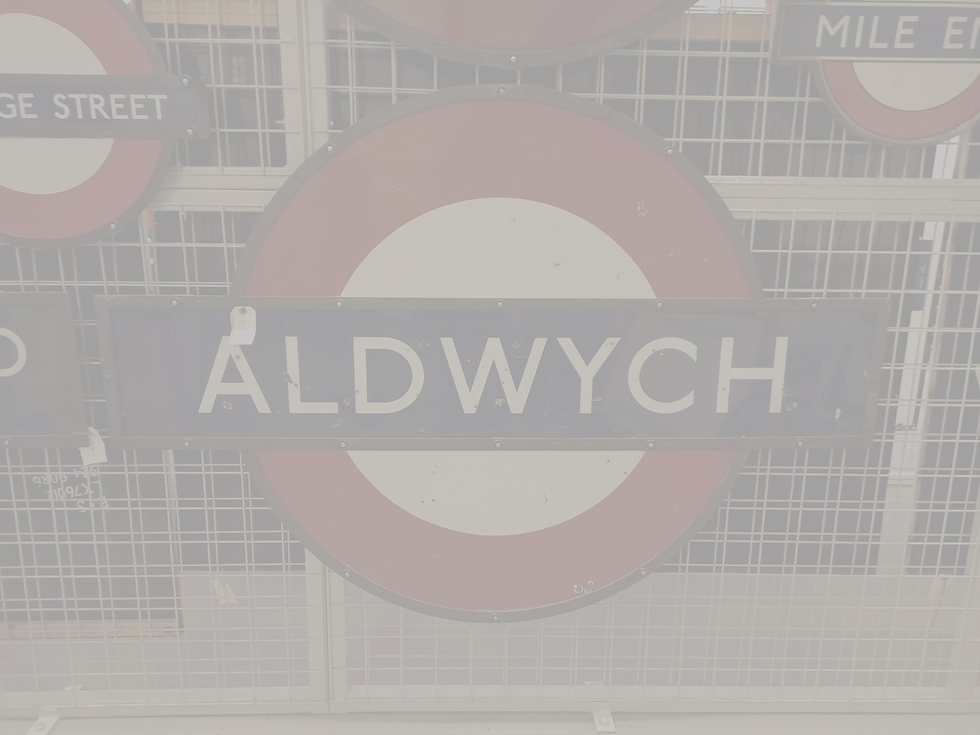
Date opened: 1907 with the name 'Strand' The name was changed at a later date as another station was also opened as Strand, which then became Charing Cross
Date closed: 1940
Reopened:1946
Closed again: 30th September 1994
Number of years open: 33 + 48
Line that it was on: Piccadilly
Nearest address today: 170 Strand, London, WC2R 2LS
Current nearest Underground station: Temple (about 6 mins walk)
Type of closure: Station and route closed
Current condition: Preserved and a listed building.
Reason for closure: Terminus of Piccadilly line branch line from Holborn; closed due to low
passenger numbers, and the cost of replacing the lifts was too expensive.
Other information: This station can be toured by pre-booking through this website:
https://www.ltmuseum.co.uk/whats-on/hidden-london/aldwych
Cartomap: here

Key Dates:
24th May 1873 - Opened by the Muswell Hill Railway (MHR) , 1st August 1873 - Closed,
1st May 1875 - Reopened, August 1882 - Closed, March 1885 - Reopened,
September 1885 - Closed, May 1889 - Reopened, approx. 1890 - Closed,
March 1891 - Reopened and renamed Alexandra Park, 1898 - Renamed Alexandra Palace,
29th October 1951 - Closed, 7th January 1952 - Reopened, 5th July 1954 - Permanently closed
Line that it was on: Northern
Nearest address today: Top of, The Avenue, London N10 2QE
Current nearest Underground/Overground station: Wood Green / Alexandra Palace
(mainline)
Type of closure: Tracks and platform removed, building remains.
Current condition: Building remains and is used as a community centre.
Reason for closure: Northern Heights plan cancelled, line cut back and removed.
Additional information can be seen at: https://youtu.be/4IuUOhp8Guc
Cartomap: Here

Date opened: 17 November 1901
Date entrance closed: 10th August 1992
Number of years open: 91
Line that it is on: Northern
Nearest address today: 397 City Rd, London EC1V 1NH
Current nearest Underground station: Angel
Type of closure: This entrance was closed, but is still in use today as a ventilation point.
Current condition: Disused, but still visible
Reason for closure: When the station was built, it was built with lifts. When the escalators
were installed the entrance was relocated and the former entrance turned into a ventilation shaft.
Cartomap: here

Date opened: 1st October 1863 (served by Underground from 1892)
Date stopped use by Underground: 10th September 1961
Number of years open: 69
Line that it was on: District / Metropolitan
Nearest address today: Aylesbury Train Station HP20 1RU
Current nearest Underground/Overground station: Aylesbury Train Station
Type of closure: Service withdrawal. This station used to be served by Underground
services, but the services were withdrawn.
Current condition: Still in use as a Mainline station. The National Rail information for this station can be found here.
Reason for closure: The service was cut back to Amersham when electric locomotive-hauled trains were replaced with A60 Stock trains. Now operated by Chiltern Railways

Date opened: 24th April 1865
Date Closed: 2nd November 1981
Number of years open: 116
Line that it was on: Central
Nearest address today: Blake Hall Road, Ongar, CM5 9FN.
Current nearest Underground/Overground station: Epping
Type of closure: Station and line closed, but not demolished.
Current condition: This is now a private residence, but the station can still be seen by train
on the Epping and Ongar railway
Reason for closure: Low usage, not financially viable to keep open
Cartomap: here

Date opened: March 1872
Date Closed: 30th November 1935
Number of years open: 63
Line that it was on: Metropolitan
Nearest address today: Tramway Business Park, Ludgershall Rd, Brill, Aylesbury HP18 9TY
Current nearest Mainline station: Haddenham & Thame Parkway (HDM), Haddenham,
Aylesbury HP17 8NX
Type of closure: Route closed
Current condition: Demolished
Reason for closure: Very low passenger numbers
Additional information can be found here
Cartomap: Here

Date opened: 30th July 1900
Date Closed: 24th September 1933
Number of years open: 33
Line that it was on: Central
Nearest address today: 2 New Oxford St, WC1A 1AD
Current nearest Underground station: Holborn
Type of closure: Station closed, but not line.
Current condition: Demolished
Reason for closure: Closed when the Central line platforms were opened at Holborn
Cartomap: Here

Date opened: Never opened.
Line that it was going to be on: Northern
Nearest address today: Collinson Court, Green Ln, Edgware HA8 8BN
Current nearest Underground/Overground station: Edgware.
Type of closure: Never opened.
Current condition: Remains of a viaduct that were constructed, but never had railway
lines on.
Reason for closure: This was planned as part of the Northern Heights project that was
started and never completed.
Additional information can be seen at: https://youtu.be/4IuUOhp8Guc
Google map: Here

Date opened: 15th December 1906
Date Closed: 29th July 1934
Number of years open: 28
Line that it was on: Piccadilly
Nearest address today: 9 Cottage Place, SW3 2BE
Current nearest Underground station: Gloucester Road ( about a 15 min walk)
Knightsbridge (about a 10 min walk)
Type of closure: Station closed, but not line.
Current condition: There is only 1 side elevation remaining, the rest of the building has
now been demolished.
Reason for closure: Low passenger numbers and creation of a new entrance to Knightsbridge station
Cartomap: Here

Date opened: Never opened
Line that it was going to be on: Northern
Nearest address today: Where the A41 meets the A411, WD23 1PD
Current nearest Underground/Overground station: Edgware /
Elstree & Borehamwood (mainline)
Type of closure: Never opened
Current condition: Abandoned mid construction
Reason for closure: This was planned as part of the Northern Heights project that was started and never completed.
Additional information: https://londonist.com/london/transport/unbuilt-northern-line
Additional information can be seen at: https://youtu.be/4IuUOhp8Guc
Google map: Here

Date opened: 30th July 1900
Date entrance closed: in the 1930s
Number of years open: about 30
Line that it is on: Central
Nearest address today: 31 - 33 High Holborn, London WC1V 6AZ
Current nearest Underground station: Chancery Lane
Type of closure: Building disused, not demolished.
Current condition: Building has been repurposed as an office block and the front remains similar to
what it was when it opened.
Reason for closure: The station was originally built with lifts and then redeveloped with escalators,
so the main entrance was relocated.
Cartomap: Here

Date opened: 1st May 1979 (Jubilee line platforms)
Date Closed: 19th November 1999 (Jubilee line platforms)
Number of years open: 20
Line that it was on: Jubilee
Nearest address today: Charing Cross station
Current nearest Underground station: Charing Cross station
Type of closure: Abandoned - platform closure, not station.
Current condition: Platforms on the Jubilee line are still in existence and connected to the
line and can be used by engineering trains.
Reason for closure: Jubilee line was extended, but it was not possible for the track alignment
to stay as it was, so was diverted away from this station
Cartomap: Here
Additional information: This section of the station can still be seen by booking a tour through the transport museum.

Date opened: 17th November 1901
Date Closed: 8th August 1922
Number of years open: 21
Line that it was on: Northern
Nearest address today: 271-273 City Rd, EC1V 1LA
Current nearest Underground station: Angel ( about a 9 min walk) / Old Street (about a
12 min walk)
Type of closure: Full station closure, but not line.
Current condition: See additional information.
Reason for closure: Closed due to low passenger numbers
Cartomap: Here
Additional information: Since closure, this has been converted into a ventilation point and then again since then, in 2020
it was redeveloped and has been turned into the "Bunhill Energy Centre" where the excess heat from the underground is turned into energy for around 800 homes. More details can be seen here.

Key Dates:
1873 Line opened by the Muswell Hill Railway (MHR), 1902 - Station opened (MHR),
Underground services ran from 1907
1930 - Closed (LNER), 1932 - Reopened (LNER), 1951 - Closed (British Rail),
1952 - Reopened (BR), 5th July 1954 - Closed (passengers) (BR), 1957 - Closed (goods) (BR)
Line that it was on: Northern
Nearest address today: 100 Woodside Ave, London N10 3JA
Current nearest Underground station: Highgate
Type of closure: Line and station closed
Current condition: Demolished and the area has been redeveloped.
Reason for closure: Northern Heights plan cancelled, line cut back and removed.
Additional information can be seen at: https://youtu.be/4IuUOhp8Guc
Cartomap: Here

Key dates: 22nd August 1867 Opened by Edgware, Highgate and London Railway
29th October 1951 - closed, 7th January 1952 - reopened, 5th July 1954 - Permanently closed
Line that it was on: Northern
Nearest address today: 83-85 Crouch End Hill, N8 8DD
Current nearest Underground/Overground station: Crouch Hill (Overground) about
an 11 mins walk / Highgate (about a 22 mins walk)
Type of closure: Line and station closed
Current condition: Demolished, but remains of station and platforms are still visible on
the Parkland Walk
Reason for closure:
This was planned as part of the Northern Heights project that was started and never completed.
Additional information can be seen at: https://youtu.be/4IuUOhp8Guc
Cartomap: Here

Date opened: 1907
Date Closed: 21st May 1932
Number of years open: 31
Line that it was on: Piccadilly
Nearest address today: 24 Down Street W1J 7JU
Current nearest Underground station: Green Park (about a 6 mins walk) / Hyde Park
(about a 5 mins walk)
Type of closure: Station closed, but line still open
Current condition: Listed building
Reason for closure: Closed due to low passenger numbers when entrances to Green Park
and Hyde Park Corner were moved closer to its location, owing to the installation of
escalators to replace original lifts.
Cartomap: Here
Additional information: This station was used by Winston Churchill during the war as a bunker and can still be seen by booking a tour through the Transport Museum

Date opened: 14th February 1904
Date Underground services stopped: 4th October 1975
Number of years open: Station is still open
Line that it was on: Northern
Nearest address today: Drayton Park Station
Current nearest station: Drayton Park
Type of closure: Service withdrawn
Current condition: Still in use as a mainline station. The National Rail information for this
station can be found here.
Reason for closure: The service was withdrawn and transferred to National Rail (British Rail)
Cartomap: Here

Key dates:
This was built as the northern terminus of the single track Edgware, Highgate and London Railway (E&HLR) and was opened on 22 August 1867 by the Great Northern Railway (GNR)
11th September 1939 - Closed to passengers, 1st June 1964 - Closed to goods
Line that it was on: Northern
Nearest address today: The Broadwalk shopping centre, HA8 7BD
Current nearest Underground station: Edgware
Type of closure: Service withdrawn and station demolished
Current condition: Demolished and redeveloped as shopping centre
Reason for closure: Service cut back to Mill Hill East as part of the Northern Heights
Cartomap: Here

Date opened: Never opened
Line that it was proposed to be on: Northern
Nearest address today: Watford By-Pass, Elstree, Borehamwood, WD6 3BL
Current nearest Underground station: Edgware
Type of closure: Unopened
Current condition: Site has been redeveloped since construction work started.
Reason for closure:
This was planned as part of the Northern Heights project that was started and never
completed.
Additional information can be seen at: https://youtu.be/4IuUOhp8Guc
More additional information can be found at: https://www.theundergroundmap.com/article.html?id=3198
Approx location on Google map: Here

Date opened: 14th February 1904
Date Closed: 4th October 1975
Number of years open: Station is still open
Line that it was on: Northern
Nearest address today: Essex Road Station
Current nearest station: Essex Road
Type of closure: Service withdrawn
Current condition: Still in use as a mainline station. The National Rail information for this
station can be found here.
Reason for closure: The service was withdrawn and transferred to National Rail (British Rail)
Cartomap: Here

Date opened: 22nd June 1907 by the Charing Cross, Euston and Hampstead Railway
Date Closed: 30th September 1914
Number of years open: 7
Line that it was on: Northern. Building closed, line still open.
Nearest address today: Euston station
Current nearest Underground station: Euston
Type of closure: Building closed, then used as a ventilation point. Station stayed open.
Current condition: As of June 2022, this was awaiting demolition ahead of HS2 construction.
Reason for closure: The station was redeveloped and a new entrance was constructed
Cartomap: Here

Date opened: 22nd August 1867
Date Closed: September 1970
Number of years open: 103
Line that it was on: This was the branch line that formed part of the Northern line
from Finsbury Park to Edgware, which closed with the rest of the Northern Heights stations
Nearest address today: Finsbury Park mainline station
Current nearest Underground/Overground station: Finsbury Park
Type of closure: line closure. Tracks removed.
Current condition: Station still in use, but the branch line has now become the Parkland Walk
Reason for closure: Line cut back as part of the Northern Heights cut backs.
Cartomap: Here

Date opened: 23rd September 1868
Date Closed: 4th July 1936
Number of years open: 68
Line that it was on: Metropolitan
Nearest address today: North Marston, MK18 3PN
Current nearest station: Mainline: Aylesbury Vale Parkway
Type of closure: Line and station closed
Current condition: Demolished
Reason for closure: Closed when Verney Junction service was cut back to Aylesbury due to
low passenger numbers
Cartomap: Here

Date opened: 1892
Date Closed: Station is still open as a Mainline station.
The National Rail information for this station can be found here.
Number of years open: Still in use
Line that it was on: Metropolitan
Nearest address today: Great Missenden
Current nearest station: Great Missenden
Type of closure: Service withdrawn 10th September 1961 and transferred to
National Rail (British Rail)
Current condition: Still in use as a Mainline station.
Reason for closure: The service was cut back to Amersham when electric locomotive-hauled trains were replaced with A60 Stock trains. Now operated by Chiltern Railways
Cartomap: Here

Date opened: 1st January 1869
Date Closed: 3rd June 1916
Number of years open: 47
Line that it was on: Metropolitan
Nearest address today: 27 Hammersmith Grove, W6 0JL
Current nearest Underground station: Hammersmith (Hammersmith & City /Circle)
Type of closure: Service withdrawn
Current condition: Demolished
Reason for closure: Service withdrawn due to low passenger numbers; station was closed in 1916 by London and South Western Railway
Cartomap: Here
_railway_station_1916%20internet.jpg)
Date opened: 28 June 1904 by the Great Northern & City Railway (GN&CR) on its underground line between Finsbury Park and Moorgate
Date Closed: This line and stations were operated by the Metropolitan Railway and its successors from 1913 until 1975 when the line, by then called the Northern City Line, was transferred to British Rail. The route is now operated by Great Northern. A new station entrance was opened in 1968 to tie in with the Victoria line opening, but this entrance did not close until escalators were installed.
Line that it was on: Great Northern
Nearest address today: Highbury & Islington station
Current nearest Underground/Overground station: Highbury & Islington station
Type of closure: Surface building closed, not demolished
Current condition: Used as a ventilation point and for signalling equipment for the Victoria line.
Reason for closure: Station entrance relocated with station redevelopment
Cartomap: Here

Date opened: originally constructed by the Edgware, Highgate and London Railway in the 1860s on its line from Finsbury Park station to Edgware station. Before the line was opened, it was purchased in July 1867 by the larger Great Northern Railway and opened 22nd August 1867.
Date Closed: 3rd July 1954
Number of years open: 87
Line that it was on: Northern
Nearest address today: Highgate Tube station (deep level platforms - opened
19th January 1941)
Current nearest Underground/Overground station: Highgate Tube station
Type of closure: Line closed and tracks removed
Current condition: Left abandoned is is decaying.
Reason for closure:
Additional information: In the link where the photo is from, it says that the Transport Museum run tours of this station. This article is out of date and the station is no longer safe for tours to take place. Where the tunnels are from here, there is a bat sanctuary and has restricted access.
Cartomap: Here

Date opened: 1907 - Aldwych branch line
Date Closed: 1994
Number of years open: 86
Line that it was on: Piccadilly - Branch line
Nearest address today: Holborn Underground station
Current nearest Underground station: Holborn Underground station
Type of closure: Line closure only.
Current condition: Abandoned platform. The rest of the station is still in use.
Reason for closure: platforms 5 & 6 at Holborn only served the branch line to Aldwych
as a shuttle service. When Aldwych closed, the platforms became redundant. 1 platform
was removed, but the other is now only used for storage.
Cartomap: Here

Date opened: 1883
Date Closed: 1st May 1909
Number of years open: 26
Line that it was on: District
Nearest address today: Hounslow Bus Garage, Kingsley Road, Hounslow, TW3 1PA
Current nearest Underground/Overground station:
Type of closure: Station and route closed, station relocated
Current condition: Demolished. The site has been redeveloped.
Reason for closure: Line was extended, but could not be done with the stations original
location, so was demolished when the new station opened.
Cartomap: Here

Date opened: 1890
Date Closed: 24th February 1900
Number of years open: 10
Line that it was on: City and South London Railway (C&SLR), (Todays Northern Line)
Nearest address today: 41-46 King William St, EC4R 9AN
Current nearest Underground/Overground station: Bank
Type of closure: Service withdrawn. Building demolished
Current condition: Demolished
Reason for closure: When the station was built, the line was too steep for electric trains to
get up and the curve of the track was too tight. The station closed when Bank opened.
Additional information: Until 2022, the platforms were still in place and could be seen by
booking a tour through the Transport museum. When the redevelopment of Bank started,
which included a new entrance and lift installation, these had to stop as this was taken through
parts of the old station.
Virtual tours can still be booked through the museum.
More can be seen on YouTube: https://www.youtube.com/watch?v=hH7MNbsUEzc
There is still a commemorative plaque on the
side of the existing building to mark the site of the station.
Cartomap: Here


Date opened: as Leigh by the London, Tilbury and Southend Railway on 1 July 1855, being renamed Leigh-on-Sea on 1 October 1904, but was rebuilt by the London, Midland and Scottish Railway on a new site
Date Closed: Station is still open. This was a service withdrawal
Line that it was on: District
Nearest address today: Leigh -on-Sea station
Current nearest Mainline station: Leigh -on-Sea station
Type of closure: Service withdrawal
Current condition: Still in use as a mainline station
Additional information: When the London Underground's District line operated a
seasonal non-stop excursion service between 1910 and 1939 through to the Southend area, Leigh-on-Sea was the first stop after Upminster.
Google map: Here

Key dates: 13th April 1868 - Opened as "St. John's Wood Road"
1st April 1925 - Rebuilt and renamed "St. John's Wood",
11th June 1939 - Renamed "Lord's"
20th November 1939 - Closed and later demolished
Replaced by todays St John's Wood
Number of years open: 71
Line that it was on: Metropolitan
Nearest address today: 18 Lodge Road, NW8 7JT
Current nearest Underground station: St. John's Wood (about an 11 mins walk)
Baker Street (about a 15 mins walk)
Type of closure: Line realignment: To ease congestion, a deep level line was created from Finchley Road to Baker Street. This was done by the Baker Street and Waterloo (Bakerloo) railway company, which then later transferred to the Jubilee line.
Current condition: Demolished and redeveloped as a hotel
Reason for closure: Station no longer required owing to realignment of the tracks
Additional information: The site is now occupied by a hotel. An emergency access point existed as of 2004 and a stairwell went to a piece of the platform remaining at the trackside as a result of it. The remnants of the platforms can be seen through the window of passing trains on the Metropolitan line.
Cartomap: Here

Date opened: on 6 October 1884 to replace the short-lived Tower of London station, which was closed when the Metropolitan Railway and District Railway were connected to form the Circle line and a larger station was required. In 1947 it was renamed "Tower Hill"
Date Closed: 4th February 1967 - replaced with the current Tower Hill station
Number of years open: 83
Line that it was on: Circle / District
Nearest address today: 14 Byward Street, EC3R 5BA
Current nearest Underground station: Tower Hill
Type of closure: Station relocation
Current condition: Abandoned. The old station entrance is narow and can be seen at street level and can still be used as an emergency exit from todays Tower Hill station
Reason for closure: Station was too cramped for the usage, needed to relocate as the existing site could not be redeveloped.
Cartomap: Here

Date opened: 13th April 1868
Date Closed: 20th November 1939
Number of years open: 71
Line that it was on: Metropolitan
Nearest address today: 64 Queen's Grove, NW8 6ER
Current nearest Underground/Overground station: St. John's Wood
Type of closure: Station closed and then abandoned.
Current condition: External building still remains. This was used as a restaurant for
a while, but is now used as an electricity substation for the Metropolitan line.
Reason for closure: Low usage when the deep level line opened between Swiss Cottage and Baker Street
Additional information: There are remains of the platforms still in situ and can be used as an emergency exit from the line.
Cartomap: Here

Key Dates:
1867 - Opened by the Great Northern Railway (GNR)
1939 - Closed (LNER)
1941 - Opened (Northern line)
1962 - Goods yard closed
Line that it was on: Northern line - extension to Edgware (LNER)
Nearest address today: Mill Hill East Underground station
Current nearest Underground station: Mill Hill East
Type of closure: Line was cut back from Edgware to Mill Hill East. This route can still
mostly be walked today - https://trainstobeyond.com/2021-uk-tube-to-take-2/
Current condition: Station still in use, but is now a terminus, rather than a through station.
Reason for closure: After the war, shortage of funds, then the Town & Country Planning Act (which led to the Bushey Heath area being made part of the Metropolitan Green Belt) led to the cancellation of the Northern Heights work in the early 1950s
Cartomap: Here

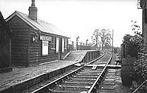
Date opened: 11th June 1906
Date Closed: 1939
Number of years open: 33
Line that it was on: Northern
Nearest address today: 2 Marchant Close, London, NW7 2GB
Current nearest Mainline station: Mill Hill Broadway
Type of closure: Line and station closed
Current condition: Demolished and the site is now located within Lyndhurst Park
Reason for closure: Service withdrawn under the Northern Heights Plan.
Cartomap: Here

Key dates: The Muswell Hill Railway (MHR) opened the station on 24 May 1873 as Alexandra Park (Muswell Hill).It was the intermediate station on the MHR's branch line from the Great Northern Railway's (GNR's) station at Highgate to Alexandra Palace. Later in 1873 it closed (MHR), 1875 - Reopened (MHR), 1951 - Closed (British Rail)
1952 - Reopened (BR), 1954Closed (passengers) (BR), 1956Closed (goods) (BR)
Line that it was on: Northern line
Nearest address today: 100 Woodside Ave, London N10 3JA
Current nearest Underground station: Highgate
Type of closure: Service withdrawn, tracks removed
Current condition: Demolished, if you walk the former track bed, there are signs of
where the station used to be, but the area has been redeveloped.
Reason for closure: Part of the Northern Heights plan.
Cartomap: Here

Date opened: Never completed
Line that it was going to be on: Northern
Nearest address today: Milbrook Court, 1A Hampstead Way, London, NW11 7JF
Current nearest Underground station: Golders Green (about a 12 min walk)
Type of closure: Station was partially constructed, but never opened
Current condition: There is an external building, which looks like a power substation
and a staircase going down to a partially constructed platform. This is used as a ventilation
shaft.
Additional information: The station was to have been built at North End on the boundaries of Hampstead Heath and Golders Hill Park and is located on the Edgware branch between Hampstead and Golders Green.
Due to its location near the top of a hill, the station would have been, at 221 feet (67 m), the deepest below ground on the entire Underground network. The station is also known as "Bull & Bush" - named after a local pub.
During the Cold War a shaft was dug down to the lower passageways and the abandoned station became part of the London Underground's civil defence preparations. As the tunnels were the deepest in the network it was an ideal site. The role of the control centre was to manage the emergency floodgates placed throughout the tube network at the start of World War II. During this period, the building at the top was disguised as an electricity substation through the appropriate signage. The exits from the platform tunnels are now marked as emergency evacuation routes from the Underground system, and its function is now publicly acknowledged.
Cartomap: Here

Key dates:
24th April 1865 Station opened by the Great Eastern Railway,
25th September 1949 - Transferred to the Central line
18th November 1957 - the line was electrified
6th January 1964- Goods yard closed, 30th September 1994 -closed again
In November 2004 - it was reopened in preservation by the Epping & Ongar Railway
in 2007 it closed again:
Line that it was on: Central
Nearest address today: North Weald Station - Epping & Ongar Railway, CM16 6BW
Current nearest Underground station: Epping
Type of closure: Services withdrawn. Tracks remained in place
Current condition: Private residence. Although the trains run through the station, they will only stop with agreed permission from the property owner.
Reason for closure: Service was withdrawn owing to low usage.
Cartomap: Here

Date opened: 16th April 1908
Date Closed: 19th May 1932
Number of years open: 24
Line that it was on: Northern
Nearest address today: Northfields Underground station
Current nearest Underground/Overground station: Northfields
Type of closure: Station relocation
Current condition: Demolished
Reason for closure: Station was relocated to allocate space for the depot to be built.
When the station was relocated, it was also renamed, losing the "Little Ealing"
Cartomap: Here

Key dates:
24th April 1865 - Station opened by the Great Eastern Railway
25th September 1949 - Transferred to London Transport Central line
18th November 1957 - line was electrified, 18th April 1966 - the goods yard was closed,
30th September 1994 - station closed
November 2004 -Reopened in preservation by Epping Ongar Railway Volunteer Rail Society
December 2007 - Station closed
25 May 2012 - Reopened by the Epping Ongar Railway
Line that it was on: Central
Nearest address today: Ongar (preserved) Railway station
Current nearest Underground station: Epping
Type of closure: Service withdrawn and line closed
Current condition: Used as a heritage station for preserved steam / diesel. NB - electrification has been removed.
Reason for closure: Low usage
Cartomap: Here

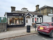
Date opened: 1883 by the District line
Date Closed: In 1934 when a new station, Osterley, was opened to the west.
Number of years open:
Line that it was on: District / Piccadilly
Nearest address today: Osterley Bookshop, 168A Thornbury Rd, Osterley, TW7 4QE
Current nearest Underground station: Osterley
Type of closure: New station built to replace this.
Current condition: The station building is now a second hand bookshop. The platforms
are still in situ, but the stairs to the former booking hall have been removed, so the
platforms can only be accessed by rail these days.
Reason for closure: New station built a short distance away
Cartomap: Here
Date opened: 25th June 1903
Date Closed: 5th July 1931
Number of years open: 28
Line that it was on: District (this is now Piccadilly)
Nearest address today: 3 St Annes Gardens, London NW10 7HL (Station would be
where the end of this garden lies.)
Current nearest Underground station: Park Royal Station
Type of closure: Station relocation
Current condition: Demolished. The location of where the station was has now been
redeveloped.
Reason for closure: Station relocated. The original station wasn't a very sturdy looking building, so a more modern building replaced it in a more suitable location.
Cartomap: Here

Key dates: (See Wikipedia for more in depth information)
23rd September 1868 opened by the Aylesbury and Buckingham Railway
1897 - Re-sited to the "London" side of new overbridge.
Between 1897 and 1936, the company was absorbed into the Metropolitan Railway.
6th July 1936 - Metropolitan services withdrawn
4th March 1963 - the Great Central Railway (GCR) passenger services withdrawn
4th July 1966 - GCR goods services withdrawn
1969 Quainton Railway Society operations commenced
1971 - Special passenger services started
1970s"Buckinghamshire Railway Centre"
Line that it was on: Metropolitan
Nearest address today: Quainton Road Station, Buckinghamshire Railway Centre, HP22 4BY
Current nearest Mainline station: Aylesbury Vale Parkway (Mainline) - about 19 mins drive - 7.2 miles
Type of closure: service withdrawn. Tracks remain in situ.
Current condition: Used as a railway heritage centre with different events during the year.
Reason for closure: Service cut back to Aylesbury.
Cartomap: Here

Date opened: 3rd March 1884 as St. Mary's (Whitechapel)
Date Closed: 30th April 1938
Number of years open: 54
Line that it was on: Metropolitan and Metropolitan District Joint Railway, and initially
used by the South Eastern Railway
Nearest address today: 100 Whitechapel Rd, E1 1JG
Current nearest Underground station: Aldgate East / Whitechapel
Type of closure: Station closure, line remained open.
Current condition: Demolished. Google street view
Reason for closure: In 1938, Aldgate East was relocated further eastwards and given a new entrance only a few hundred yards from St. Mary's (Whitechapel Road) rendering the latter surplus to requirements. It was permanently closed after the last train on 30 April 1938 in advance of Aldgate East being resited.
Cartomap: Here

Looking at the Wikipedia page for List of former and unopened London Underground stations. There is only 1 station listed under "Shepherd's Bush" and this takes you to Shepherd's Bush Market tube station.
However on the Cartomap, there are 3 stations labelled as "Shepherd's Bush"
1 - Opened 1864 and closed 1st November 1869 and is labelled as "Hammersmith & City Kensington Branch" on the map. There is not a lot of information available about this station, but from this website, it looks like it was just a halt and was replaced with Uxbridge Road (also known as Shepherd's Bush), which was later demolished and is now the existing Shepherd's Bush Overground station.
2- This one was located on what is now the Hammersmith & City line (shown here) and was between Goldhawk Road and Shepherd's Bush Market (which has also been know as "Shepherd's Bush" and was opened from 13th June 1864 to 31st March 1914, this was closed to allow for the stations either side to be built.
3 - This one opened 1st May 1874 and closed 5th June 1916 and was located between Hammersmith (Grove Road) station and what is now Kensington (Olympia). This line was removed and the area was redeveloped. The spur for this line can still be seen on the left side of the tracks as you travel from Ravenscourt Park to Hammersmith on the District/Piccadilly lines and the other end is no longer visible.
Additional information: This diagram shows the Wood Lane / White City / Shepherd's Bush stations
If you have any further knowledge for this website to be updated, please use the contact us page.
Date opened: 1884 by the London, Tilbury and Southend Railway
Date Closed: Still in use as a mainline station
Line that it was on: District
Nearest address today: Shoeburyness Rail Station , High Street, Shoeburyness,
Essex, SS3 9AW
Current nearest Mainline station: Shoeburyness
Type of closure: Services withdrawn from 30th September 1939
Current condition: Still in use as a Mainline station
Reason for closure: London Underground's District line operated a seasonal
non-stop excursion train service between 1910 and 1939 through to the Southend
area, Shoeburyness was the terminus
Google maps: Here

Date opened: 18th April 1876 by the East London Railway
Date Closed: 9th June 2006
Number of years open: 130
Line that it was on: East London line
Nearest address today: Daniel Gilbert House, 1 Code St, Brick Lane, E1 5ER
Current nearest Underground/Overground station:
Shoreditch High Street (Overground) ( about a 5 mins walk)
Liverpool Street (about a 15 mins walk)
Type of closure: Station re-sited and route re-aligned
Current condition: External building still remains. This has just been left.
Reason for closure: Closed to allow extension of East London Line on new alignment across site. Replaced by London Overground station Shoreditch High Street.
Cartomap: Here

Deep level station external building only.
Date opened: 15 December 1906 by the Great Northern, Piccadilly and Brompton
Railway as an addition to the existing District/Circle line station
Date Closed: Early 1970's
Line that it was on: This building served as lift access to the Piccadilly line and the
District line
Nearest address today: 2 Pelham St, South Kensington, London SW7 2NG
Current nearest Underground station: South Kensington
Type of closure: External building disused
Current condition: Still visible from the street and is now used as a ventilation point for the Piccadilly line. There are remnants of the old station platform canopies and there is also evidence of where tracks have been lifted and the station has been altered.
Reason for closure: Station was modified. Lifts removed and escalators installed, creating a new entrance.
Cartomap: Here

Date opened: 22nd June 1907
Date Closed: 5th June 1924
Number of years open: 17
Line that it was on: Northern
Nearest address today: 141-145 Kentish Town Rd, NW1 8PB
Current nearest Underground/Overground station: Camden Town (about8 mins walk)
Kentish Town (about 9 mins walk), Kentish Town West (Overground - about 8 mins walk)
Type of closure: Station closure. Line remained open
Current condition: External building remains, platforms have been removed, the
building has been converted into a retail space at the top.
Reason for closure: The station was temporarily closed following unofficial strike action at Lots Road Power Station during the afternoon of 5 June 1924. It was decided not to re-open the station after the power was restored, due to the very low number of passengers using it; in fact, since as early as 1908 some trains did not stop there
Additional information: There is now an escape room underneath: https://www.missionbreakout.london/
Cartomap: Here

Date opened: in 1856 by the London, Tilbury and Southend Railway
Date service withdrawn: 30th September 1939
Number of years open: Station still in use
Line that it was on: District
Nearest address today: Southend Central station
Current nearest Mainline station: Southend Central station
Type of closure: Service withdrawn.
Current condition: The station is still in use as a mainline station
Reason for closure: When the London Underground's District line operated a seasonal
non-stop excursion train service between 1910 and 1939 through to the Southend area,
Southend Central was the second station to be called at after departing Upminster.
Google map: Here

Date opened: 1 September 1892, by the Metropolitan Railway,
when its main line was extended from Chalfont Road to Aylesbury Town.
Date service withdrawn: 10th September 1961
Line that it was on: Metropolitan
Nearest address today: Stoke Mandeville station
Current nearest Mainline station: Stoke Mandeville station
Type of closure: Service cut back to Amersham
Current condition:
Reason for closure: Line electrification only went as far as Amersham and at that
time it was not a good financially viable option to extend any further.
Additional information: Responsibility for the station (and the railway north of Amersham to Aylesbury) was transferred from London Transport to British Railways on 11 September 1961;
Cartomap: Here

Key dates: This was built by the Great Northern Railway (GNR) and opened on the railway's
existing Edgware, Highgate and London Line on 11th April 1881.
On 29th October 1951 it closed and then reopened 7th January 1952 and then on
5th July 1954, it permanently closed.
Line that it was on: Northern
Nearest address today: 73C Stapleton Hall Rd, Finsbury Park, London N4 3QF
Current nearest station: Crouch Hill (Overground - about a 4 mins walk)
Harringay (Mainline - about a 10 mins walk)
Type of closure: Line closure. Tracks removed.
Current condition: The building has been demolished and the station masters house has been repurposed and access to the tracks removed.
Reason for closure: This is one of the stations that closed as part of the Northern Heights plan
Cartomap: Here

Date opened: 1868 as the northern terminus of the Metropolitan and St. John's Wood Railway (M&StJWR)
Date Closed: 17th August 1940
Number of years open:
Line that it was on: 72
Nearest address today: 131 Finchley Rd, NW3 6HY
Current nearest Underground/Overground station: Swiss Cottage
Type of closure: Line realignment, original station demolished. New entrances built
Current condition: Demolished in the 1960s to allow the widening of Finchley Road,
but the former platform area still exists in part.
Reason for closure: Deep level line introduced to ease congestion. New station entrance built.
Additional information: For the new deep-level route, a new Bakerloo line station named Swiss Cottage was opened adjacent to the existing Metropolitan line station. For a time, they operated as a single station (platforms 1 and 2 were for the Metropolitan line, and platforms 3 and 4 were for the Bakerloo line). This arrangement was short-lived, however, and the Metropolitan line Swiss Cottage station was closed after the last train on 17th August 1940 as a wartime economy.[2] On 1 May 1979, the Stanmore branch of the Bakerloo line was transferred to the new Jubilee line
Cartomap: Here

Date opened: 1882
Date Closed: 1884
Number of years open: 2
Line that it was on: It was opened on 25 September 1882 during the construction of the Metropolitan Railway (MR) to the north. Two years later, the MR and District Railway (now the District line) were connected to form the Inner Circle (now the Circle line) and a new station was built. This new station was opened on 6 October 1884 with the name Mark Lane
Nearest address today: Tower Hill Underground station
Current nearest Underground station: Tower Hill
Type of closure: Station relocation
Current condition: Demolished - When the original Tower Hill station was itself closed in 1967, the current Tower Hill station was opened on the site of the closed Tower of London station. The remains of the Tower of London station were demolished during the construction of the new Tower Hill station
Reason for closure: Station re-sited
Cartomap: Here (location of Tower Hill today)
No image found for the original station building
Date opened: The Harrow and Uxbridge Railway (later merged into the Metropolitan
Railway) first opened a station in Uxbridge on 4 July 1904 on Belmont Road, a short
distance to the north of the existing station.
Date Closed: 4th December 1938 when the current station was opened on a new
alignment
Number of years open: 34
Line that it was on: Metropolitan
Nearest address today: Sainsbury's, York Rd, Uxbridge, UB8 1QW
Current nearest Underground/Overground station: Uxbridge
Type of closure: Station realignment to allow for more tracks / services
Current condition: Demolished and redevolped as a Sainsbury's supermarket
Reason for closure:
Cartomap: Here

Date opened: was a railway station on the West London Railway from 1869 to 1940. It was initially served by London & North Western Railway and the Great Western Railway. In 1905 the line became a branch of the Metropolitan Railway, and later London Underground's Metropolitan line
Date Closed: 21st October 1940 during World War II, when the West London Line was put
out of service during the Blitz.
Line that it was on: Metropolitan
Nearest address today: Thames water Tower, W11 4TS
Current nearest Overground station: Shepherd's Bush Overground - the platforms today
are where the platforms used to be
Type of closure: Service withdrawn, station closed
Current condition: Demolished and the area has been redeveloped
Reason for closure: Wartime measures.
Cartomap: Here

Date opened: 23rd September 1868 by the Aylesbury and Buckingham
Railway (later owned by London Underground)
Date Closed: 1st January 1968
Number of years open: 100
Line that it was on: Metropolitan
Nearest address today: Jubilee Cottages, Verney Junction, MK18 2JZ
Current nearest Mainline station: Bicester Village (Mainline)
Type of closure: Service withdrawn, tracks removed
Current condition: Demolished
Reason for closure: Closed when service was cut back to Aylesbury due to low passenger numbers
Cartomap: Here

Date opened: The station was first opened as Waddesdon Manor by the Metropolitan Railway on 1 January 1897. "Manor" was dropped from the name on 1 October 1922. It was the first station north of Aylesbury on the section of the Metropolitan Railway between Aylesbury and Verney Junction.
Date Closed: July 1936
Line that it was on: Metropolitan
Nearest address today: Blackgrove Road, Waddesdon, HP22 4AG
Current nearest Mainline station: Aylesbury Vale Parkway
Type of closure: Service withdrawn, station closed
Current condition: Today one platform of the station (on the side remote from the
remaining track) remains; the other has been demolished. Until 2021 the line was used
for a daily freight train carrying waste from London to Calvert, as well as special services
between Aylesbury and Quainton Road for events at the Buckinghamshire Railway Centre.
Reason for closure: Closed when service was cut back to Aylesbury due to low passenger numbers
More information can be found at: https://waddesdon.org.uk/blog/disused-tube-station-waddesdon-manor/

Date opened: opened in 1871 as part of a short horse-drawn tramway to assist with the transport of goods from and around the Duke of Buckingham's extensive estates in Buckinghamshire and to connect the Duke's estates to the Aylesbury and Buckingham Railway at Quainton Road. In 1872 the line was expanded and converted for passenger use, becoming known as the Brill Tramway. In 1899 the operation of the line was taken over by the London-based Metropolitan Railway.
Date Closed: July 1936
Line that it was on: Metropolitan
Nearest address today: Waddesdon Manor, HP18 0JH
Current nearest Mainline station: Aylesbury Vale Parkway
Type of closure: Service withdrawn, tracks removed
Current condition: Demolished
Reason for closure: Closed when service was cut back to Aylesbury due to low
passenger numbers
Cartomap: Here

Date opened: 1 September 1892 by the Metropolitan Railway (Met), when the railway was extended from Chalfont Road to Aylesbury Town. The Great Central Railway served the station from 1899
Date service withdrawn: 10th September 1961
Line that it was on: Metropolitan
Nearest address today: Wendover mainline station
Current nearest Mainline station: Wendover
Type of closure: Service withdrawn
Current condition: Still in use as a Mainline station
Reason for closure: The service was cut back to Amersham when electric locomotive-
hauled trains were replaced with A60 Stock trains. Now operated by Chiltern Railways
Google map: Here

Key dates:
1871 line opened for freight only, 1872 - opened for passengers, 1894 - rebuilt
1899 - leased by the Metropolitan Railway, 1935 - tracks removed by London Transport
Date Closed: On 1 July 1933 the Metropolitan Railway, along with London's other underground railways aside from the small Waterloo & City Railway, was taken into public ownership as part of the newly formed London Passenger Transport Board (LPTB). As a consequence, despite it being 43 miles (69 km) from the City of London, Westcott station became part of the London Underground network. The Brill Tramway was by this time losing significant sums of money. Goods traffic had dwindled, and unlike other areas served by the former Metropolitan Railway, passenger numbers were low; in 1932 Westcott station saw only 1,560 passengers and collected only £27 (about £2,000 in 2023) in passenger receipts
Line that it was on: Metropolitan
Nearest address today: Station House, Ashendon Road, Westcott, HP18 0NX
Current nearest Mainline station: Aylesbury Vale Parkway, (about a 20 min drive - 7.1 miles)
Type of closure: Line closed, track removed.
Current condition: Building remains as a private residence
Reason for closure: Line cut back to owing to low usage
Additional information: It was built by the Duke of Buckingham in 1871 as part of a short horse-drawn tramway to allow for the transport of goods from and around his extensive estates in Buckinghamshire and to connect the Duke's estates to the Aylesbury and Buckingham Railway at Quainton Road. A lobbying campaign by residents of the town of Brill led to the tramway being converted for passenger use and extended to Brill railway station in 1872, becoming known as the Brill Tramway.
Cartomap: Here
Key Dates: Opened 1st May 1908 (as Wood Lane), closed 3rd October 1914
Reopened 5th May 1920, and then renamed 23rd November 1947
Then it finally closed 24th October 1959
Line that it was on: Metropolitan
Nearest address today: 10 Shepherds Bush Place, W12 8LX
Current nearest Underground/Overground station: Shepherd's Bush Market is
almost where this station was
Type of closure: Station relocation
Current condition: Demolished
Additional information 1: This was a station on the London Underground that was located in Shepherd's Bush, west London. It was opened in 1908 on the Hammersmith branch of the Metropolitan Railway (now the Hammersmith & City line), on the viaduct adjacent to the bridge over Wood Lane and close to a station of the same name but on the Central London Railway (now the Central line).
It was closed temporarily in 1914, reopened in 1920 and eventually closed permanently in 1959 at which time it was served by the Metropolitan line.
The two Wood Lane stations were opened in 1908 to serve the Franco-British Exhibition and the 1908 Olympic Games in the area that was to become known as White City. The Metropolitan Railway's Wood Lane opened with the name Wood Lane (Exhibition) on 1 May 1908 and the Central London Railway's Wood Lane station opened on 14 May 1908. Both were intended to be temporary and to be closed after the exhibition and the Games. Wood Lane (Exhibition) station was closed on 31 October 1914, shortly after the outbreak of the First World War. The other Wood Lane became the permanent western terminus of the Central London Railway.
Additional information 2: This diagram shows the Wood Lane / White City / Shepherd's Bush stations
This station was unique with its moving platform, which you can read about here.
Cartomap: Here

Date opened: 8th October 1849 by the Great Western Railway. In 1863, the Metropolitan Railway
opened the world's first underground railway, between London Paddington and Farringdon Street
and the Great Western Railway ran regular through services to Windsor from Farringdon. Initially
these were broad gauge trains, as the original Metropolitan was laid for mixed standard and
broad gauges and, for some months, the engines and coaches were hired from the GWR. By
1865, there were ten trains daily on the route.
Service withdrawn: 30th September 1885
Line that it was on: Metropolitan (and District from 1883)
Nearest address today: Windsor & Eton Central station
Current nearest Mainline station: Windsor & Eton Central
Type of closure: Service withdrawn.
Current condition: Still in use as a Mainline station
Google map: Here

Date opened: By the Aylesbury and Buckingham Railway (A&BR)
on 23rd September 1868
Date Closed: 6th July 1936
Number of years open: 68
Line that it was on: Metropolitan
Nearest address today: Station House, E Claydon Rd, Winslow, Buckingham, MK18 3NF
Current nearest Mainline station: Bletchley
Type of closure:
Current condition: Redeveloped as a private residency, and the remains of the
platform can still be seen in the garden at the rear.
Reason for closure: Closed when Verney Junction service was cut back to Aylesbury due to low passenger numbers
Cartomap: Here

Key Dates: Opened 14th May1908 (loop platform),
3rd August 1920 (through platforms)
Date Closed: 22nd November 1947
Number of years open: 39
Line that it was on: Central
Nearest address today: Westfield Shopping Centre, Ariel Way, W12 7GF
Current nearest Underground station: Shepherd's Bush
Type of closure: Station relocated
Current condition: Demolished and redeveloped as a shopping centre
Reason for closure: With additional services and lines being added, this station needed to be redeveloped or relocated.
Wood Lane station was built to serve the 1908 Franco-British Exhibition and the 1908 Olympic Games. Its location was very confined and its configuration awkward, requiring alterations on a number of occasions to meet operational requirements.
It closed in 1947 following the opening of the nearby White City station. In 2008, a new Wood Lane station was opened nearby on the Circle and Hammersmith & City lines.
Until the station's demolition between 2003 and 2005, the old eastbound platform could still be seen from passing trains heading from White City to Shepherd's Bush and the former eastbound platform was incorporated into the new depot's roads using the single track, which can clearly be seen when leaving White City station when travelling to Shepherd's Bush.
Additional information: This diagram shows the Wood Lane / White City / Shepherd's Bush stations
Cartomap: Here
_tube_station_2001%20internet.png)
Date opened: in 1871 as a terminus of a short horse-drawn tramway built to assist the transport of goods from and around the Duke of Buckingham's extensive estates in Buckinghamshire, as well as connect the Duke's estates to the Aylesbury and Buckingham Railway at Quainton Road.
Date Closed: 30th November 1935
Number of years open: 64
Line that it was on: Metropolitan
Nearest address today: Aylesbury, HP18 0SD
Current nearest Mainline station: Bicester North
Type of closure: Service withdrawn, line closed. Track removed.
Current condition: Demolished - land left to nature to reclaim.
Reason for closure: Closed when Brill branch was closed due to very low passenger numbers
Cartomap: Here

Date opened: This was built by the Duke of Buckingham in 1871. Part of a private horse-drawn tramway designed to carry freight from and around his lands in Buckinghamshire, Wotton station was intended to serve the Duke's home at Wotton House and the nearby village of Wotton Underwood. In 1872 the line was extended to the nearby village of Brill, converted to passenger use, equipped with steam locomotives, and renamed the Brill Tramway.
Date Closed: 30th November 1935
Number of years open: 64
Line that it was on: Metropolitan
Nearest address today: Aylesbury HP18 0SD
Current nearest Mainline station: Bicester North
Type of closure: Service withdrawn, line closed. Track removed.
Current condition: Demolished - site redeveloped as part of Waddesdon Manor
Reason for closure: Closed when Brill branch was closed due to very low passenger
numbers
Cartomap: Here
%20internet.jpg)
Date opened: 15th December 1906
Date Closed: 19th September 1932
Number of years open: 26
Line that it was on: Piccadilly
Nearest address today: 176-178 York Way, N1 0AZ
Current nearest Underground/Overground station: King's Cross (about a 10 mins
walk), Caledonian Road (about an 18 mins walk), Kings Cross St Pancras ( about 12 mins)
Type of closure: Service withdrawn, building closed, not demolished
Current condition: External building still remains, platforms are still in situ,so acts as a ventilation point. The building is not structurally safe to use, but may reopen in the future as the area is being redeveloped (as of 2022) with high rise apartment blocks.
Reason for closure: Being sited in a poor industrial area, the station saw little use, and from October 1909, some trains did not stop at the platforms, in order to improve service times to the other stations. The Sunday services were withdrawn entirely from 5 May 1918. The station remained open for weekday and Saturday traffic only, and closed on 4 May 1926, when the general strike began. Although the strike only lasted for nine days, the station remained closed. However the subject of its closure was eventually raised in the House of Commons, and it reopened in October 1926, but the reprieve was short-lived, lasting until 19 September 1932 when it was permanently closed. The closure occurred on the same day as the northern extension of the Piccadilly Line from Finsbury Park to Arnos Grove opened
Cartomap: Here

Head Office
Date opened: Built between 1927 and 1929
Date Closed:London Transport occupied the building from 1933 to 1984, followed by its successors London Regional Transport from 1984 to 2000, and Transport for London (TfL) from 2000 to 2020. TfL vacated the building in 2020
Number of years open: 67
Line that it was above: Circle / District
Nearest address today: 55 Broadway, SW1
Current nearest Underground/Overground station: Located above St. James's Park
Type of closure: Disused and is now a listed building
Current condition: External building still remains. In May 2020, it was announced that Blue Orchid Hotels, a subsidiary of Integrity International, would convert the structure into a luxury hotel
Reason for closure: Relocated Head Office as TfL