
Background photo taken at Warren Street

Waddon Marsh tram stop is a stop on the Tramlink service serving the area between Waddon and Croydon in the London Borough of Croydon. It is close to the commercial areas of the Purley Way. The stop is overshadowed by the giant gasometer of Croydon Gas Works. There was previously a railway station about 100 metres north of this site called Waddon Marsh, though all that remains of the previous station is an access path still lined with streetlamps painted BR red.
The platforms here are open air.

2 for the Overground
2 for the Underground
Yes for Underground, but not for Overground
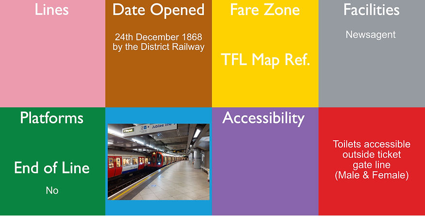
Walthamstow Central (originally called ‘Hoe Street’) is a London Underground and National Rail interchange station in the town of Walthamstow in the London Borough of Waltham Forest, north-east London. It is the northern terminus of the Victoria line following Blackhorse Road and is the second of five stations on the Chingford branch of the Lea Valley lines operated by London Overground since 2015, 6 miles 16 chains (10.0 km) from London Liverpool Street between St. James Street and Wood Street. The two lines have separate platforms at different levels. The mainline station was opened in 1870 by the Great Eastern Railway and the Victoria line was opened 1st September 1968.
The station is in Travelcard Zone 3. It linked to Walthamstow Queen's Road station on the Gospel Oak to Barking line by a broad footpath, Ray Dudley Way. Walthamstow Central is the closest tube station to Walthamstow Market, the longest outdoor market in Europe.
The National Rail information for this station can be found here.
There is a museum called Walthamstow Pumphouse, where they have some old rolling stock converted into a restaurant, however the closest station is actually St. James Street.
The overground platforms are open air and at street level and the underground platforms are about 16.5 metres underground

Walthamstow Queen's Road railway station is a London Overground station between Blackhorse Road and Leyton Midland Road stations on the Gospel Oak to Barking Line, 8 miles 7 chains (13.0 km) down the line from Gospel Oak. It is in Zone 3. It opened as "Walthamstow" on 9 July 1894 and was renamed on 6 May 1968 under British Rail.
The station is about 330 yards (300 m) from Walthamstow Central station and there is a direct footpath link between the two stations via a new exit onto Exeter Road. The footpath link, which opened in August 2014, is called Ray Dudley Way in commemoration of a local man who campaigned for the link for many years.
The National Rail information for this station can be found here.
The platforms here are open air and are in a cutting.
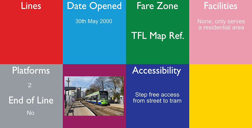
Wandle Park tram stop is a stop adjacent to Wandle Park in the London Borough of Croydon in the southern suburbs of London. It serves the residential area between central Croydon and Waddon.
The tram stop is located on a double track section of line, with platforms on either side of the track. Immediately to the east of the stop, the line reduces to single track and rises on a steep gradient in order to pass over the railway line on a bridge.
Until December 2019, it was a request stop in both directions. It is now a compulsory stop for trams towards Croydon, but a request stop for trams towards Wimbledon. The platforms here are open air.

Wandsworth Road railway station is a National Rail station between Battersea and Clapham in south London. It is served by London Overground services between Clapham Junction and Dalston Junction, with a limited service to Battersea Park, and a daily Southeastern service to Ashford International once a day. It is 1 mile 75 chains (3.1 km) from London Victoria.
The station opened on 1 March 1863, on the London, Chatham and Dover Railway original double-track low-level route from Victoria via Stewarts Lane, which was opened between Victoria and Herne Hill, on 25 August 1862.
The National Rail information for this station can be found here
The platforms here are open air.

Wanstead is a London Underground station in Wanstead in the London Borough of Redbridge, east London. on the Hainault loop of the Central line. Towards Central London the next station is Leytonstone. Towards Woodford it is Redbridge.
It is in Travelcard Zone 4.
Construction of the station had started in the 1930s, but was delayed by the onset of World War II. The incomplete tunnels between Wanstead and Gants Hill to the east were used for munitions production by Plessey between 1942 and 1945.The station was finally opened on 14 December 1947. The building, like the other two below ground stations on the branch, was designed by architect Charles Holden. It kept its original wooden escalator until 2003, one of the last Tube stations to do so.
The platforms are about 18.8 metres underground.
More photos can be seen at: https://tubemapper.com/holland-park-station/

Wanstead Park is a railway station in Forest Gate, London. It is on the Gospel Oak to Barking Line in Zone 3, 11 miles 11 chains (17.9 km) down the line from Gospel Oak and situated between Leytonstone High Road and Woodgrange Park. It is operated by London Overground.
Despite its name, Wanstead Park Station is not situated in Wanstead but in Forest Gate - and it is not near Wanstead Park but Wanstead Flats. The station was opened 9 July 1894.
The National Rail information for this station can be found here

Wapping (originally Wapping & Shadwell) is a station on the East London line located on the northern bank of the River Thames in Wapping within the London Borough of Tower Hamlets. The station is served by National Rail London Overground services under the control of the London Rail division of Transport for London, however there is no standard red National Rail "double arrow" logo signage located at the station, instead only the Overground roundel. The station is between Shadwell and Rotherhithe, and is in Travelcard Zone 2.
After temporary closures for remodelling, the station reopened for preview services on 27th April 2010 for services to New Cross and New Cross Gate, and from 23rd May 2010 trains to and from New Cross Gate were extended to West Croydon and Crystal Palace.
The station occupies the north end of the former Thames foot tunnel built by Marc Isambard Brunel between 1825 and 1843, and subsequently adapted for railway traffic.
Underground trains of the Metropolitan and the District Railways first served the station on 1 October 1884, but the station was last served by District trains on 31 July 1905.
In 1980 a London Underground plan to extend the Jubilee line to Woolwich Arsenal and Beckton was approved by parliament.
The National Rail information for this station can be found here.
The platforms are underground at about 18 metres, which is the deepest overground station. Although the station does have lifts, there are still steps to get to the trains.

2 for Northern line
2 for Victoria line
Warren Street is a London Underground station, located at the intersection of Tottenham Court Road and Euston Road, named after nearby Warren Street. It is part of the Northern and Victoria lines.
The station was part of the original Charing Cross, Euston & Hampstead Railway, running from Charing Cross to Camden Town. Work started on the station in 1902, designed by Leslie W. Green. It was opened along with the rest of the line on 22nd June 1907 by the President of the Board of Trade, David Lloyd George, under the name "Euston Road". It was rebuilt in 1933, when escalators were installed. The Victoria line was opened 1st December 1968, so the cross section underground has been remodelled to accommodate this.
The platforms are underground at about 22.2 metres - Victoria Line and 25.6 metres - Northern Line
This is 1 of only a few stations where there is "right-hand running" (Victoria line only) where trains arrive from your right, rather than left - the others are White City and London Bridge. This can be seen on the Cartomap here.
On 27 April 2012 Warren Street station became the first London Underground WiFi enabled tube station

Warwick Avenue is a London Underground station in Little Venice in the City of Westminster in northwest London. The station is on the Bakerloo line, between Paddington and Maida Vale stations, and is in Travelcard Zone 2.
Warwick Avenue opened on 31st January 1915 on the Bakerloo tube's extension from Paddington to Queen's Park.
The ticket hall and its ticket machines were destroyed by fire overnight on 17th September 1985, causing the station to be closed for the day.
There is no surface building and the station is accessed by two sets of steps to a sub-surface ticket hall. It was one of the first London Underground stations built specifically to use escalators rather than lifts. A plain, utilitarian brick ventilation shaft has been built on the traffic island in the middle of the road to improve ventilation of the tunnels. The platforms are about 16.2 metres underground.
More photos can be seen at: https://tubemapper.com/warwick-avenue-station/

See notes below
Step free access from street to train.
Jubilee only
2 for Bakerloo
2 for Northern
2 for Jubilee
*2 for Waterloo & City *

There are various food and retail outlets on the mainline concourse
Toilets accessible outside ticket gate line
(Male & Female
& Disabled)
Only for Mainline and
Waterloo & City
Waterloo is a London Underground station located beneath Waterloo National Rail station. As of 2020, it is the 5th busiest station on the London Underground, with 16.62 million users. It is served by four lines: the Bakerloo, Jubilee, Northern and Waterloo & City lines.
The station is situated in fare zone 1 and is located near the South Bank of the River Thames, in the London Borough of Lambeth. It is within walking distance of the London Eye.
The first Underground Line at Waterloo was opened on 8th August 1898 by the Waterloo & City Railway (W&CR), a subsidiary of the owners of the main line station, the London and South Western Railway (L&SWR). The W&CR, nicknamed "The Drain", achieved in a limited way the L&SWR's original plan of taking its tracks the short distance north-east into the City of London. (Bank)
On 10th March 1906, the Baker Street & Waterloo Railway (now the Bakerloo line) was opened. On 13th September 1926, the extension of the Hampstead & Highgate line (as the Charing Cross branch of the Northern line was then known) was opened from Embankment to the existing City and South London Railway station at Kennington with a new station at Waterloo.
The National Rail information for this station can be found here. The station was comprehensively refurbished in the early 1990s as part of the construction of Waterloo International station for international Eurostar service and the Jubilee line was opened 24th September 1999.
* The platforms on the Waterloo & City line are numbered 25 & 26 as these are a continuation of the Mainline station platform numbers and the Waterloo & City line depot is located just beyond the platform here.
There is an elephant sculpture in the booking hall. More details can be found here.
The platforms are underground at these approx depths: Waterloo & City 12.2 metres, Bakerloo (Southbound) 16.4 metres,
Bakerloo (Northbound) 19.5 metres, Northern 21.3 metres, Jubilee 33 metres.
The Bakerloo platform tiles are designed to look like a piano keyboard.
More photos can be seen at: https://tubemapper.com/waterloo-station/

Watford tube station is the terminus of a Metropolitan line branch line in the north-western part of London Underground in Zone 7. The station opened in 1925. It is approximately 1 mile (1.6 km) from the town centre, which is more immediately served by Watford High Street and Watford Junction stations. The station building was designed by the Metropolitan Railway's architect Charles Walter Clark.
There was a project, known as the Croxley Rail Link, involved connecting the Metropolitan line to the disused Watford and Rickmansworth Railway line and reinstating the Croxley Green branch to Watford High Street
On 25th January 2017, the Watford Observer newspaper published an update on the Croxley Rail Link confirming work had stopped as there was an ongoing funding issue. This station is now a listed building.
The platforms are open air here and there is are stabling sidings here. If you are going to the town centre, Watford High Street station is closer than this one.
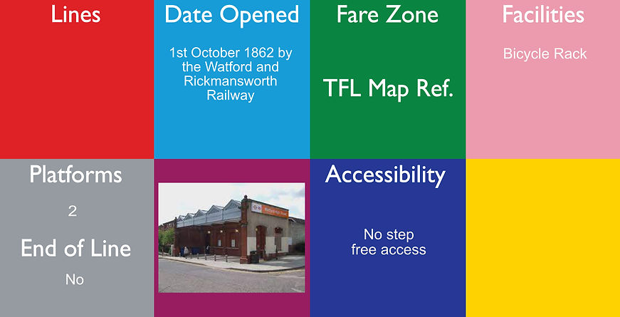
Watford High Street is a railway station in Watford, Hertfordshire, United Kingdom. It is served by the Watford DC line on the London Overground network. It is the only station on the line's sole deviation from the West Coast Main Line.
The station was opened by the Watford and Rickmansworth Railway (W&RR) on 1st October 1862, with services running from Watford Junction to Rickmansworth (Church Street). In 1912 a branch was opened to Croxley Green. The line came under the ownership of London and North Western Railway (LNWR), which was absorbed into the London, Midland and Scottish Railway (LMS) in 1923, following the grouping of Britain's railway companies.
From 16th April 1917 to 24th September 1982 the Bakerloo line ran here.
The National Rail information for this station can be found here. The platforms here are in a cutting and are partially covered with a canopy.
If you are travelling to Central London, it is normally quicker to travel to Bushey and get a main line service

4 for the Overground
6 for the Mainline
Yes for the Overground
No for the Mainline
Watford Junction is a railway station that serves Watford, Hertfordshire. The station is on the West Coast Main Line (WCML), 17 miles 34 chains from London Euston and the Abbey Line, a branch line to St Albans. Journeys to London take between 16 and 52 minutes depending on the service used: shorter times on fast non-stop trains and slower on the stopping Watford DC line services. Trains also run to Clapham Junction and East Croydon via the West London Line.
The national Rail information for this station can be found here. The platforms here are open air.
The platforms here are open air. The original building opened 20th July 1837 and was relocated in 1858, it was then Redeveloped
in 1909 and again in the 1980's, which has left platform number 5 disused.
Normally, if you are travelling to Central London, it is quicker to travel on a main line service.
From 16th April 1917 to 24th September 1982 the Bakerloo line ran here.

Wellesley Road tram stop is a halt on the Tramlink service in the London Borough of Croydon. It consists of a single platform on Wellesley Road at the diverge just before the Croydon Underpass and is served southbound only. All Tramlink routes call at the stop. at this single direction, single platform, which is open air.

See notes below
Wembley Central is an interchange station on the West Coast Main Line (WCML), London Overground and London Underground on the Watford DC line in Wembley, in north-west London, served by suburban services operated by London Underground and Arriva Rail London and regional services operated by London Northwestern Railway and Southern services. It is on the east-west High Road. The station serves Wembley Stadium and the nearby Wembley Arena. Key dates for this station:
-
20 July 1837: London and Birmingham Railway line opened, but no station, 1842 station opened as "Sudbury", 1st May 1882 it was renamed "Sudbury & Wembley", 1st November 1910 it was renamed "Wembley for Sudbury", 16 April 1917 Bakerloo line services commenced, 1948 the street level buildings were reconstructed within a shopping arcade, 5t July 1948 it was renamed "Wembley Central", 24th September 1982 the Bakerloo line service withdrawn, 4th June 1984 the Bakerloo line service was re-instated, in June 2008 the station building was demolished for re-development and between 2009-2015 there was a major re-development of the station and the area.
The National Rail information for this station can be found here. There was an accident here in 1984.
This station has got 7 platforms. Platforms 1 & 2 are shared with the Bakerloo line and the Overground, so are mid height, platforms 3 & 4 & 7 are now abandoned, platforms 5 & 6 are for mainline services. The platforms all run parallel with each other.

Wembley Park is a London Underground station in Wembley Park, north west London. The station is served by the Underground's Metropolitan and Jubilee Lines and is in Travelcard Zone 4. It is located on Bridge Road (A4089) and is the nearest Underground station to the Wembley Stadium and Wembley Arena complex. This is where the Jubilee line from Stanmore diverges from the Metropolitan line which was formerly a branch of the Metropolitan Railway and was taken over by the Bakerloo line and today part of the Jubilee line.
The lines ran through here from 1880, but the station didn't open until on 14th October 1893 and initially operated to serve only Saturday football matches in the park. It opened fully on 12th May 1894. There are 4 platforms for the Metropolitan line and 2 for the Jubilee (which run through the middle)
Neasden depot is just to the south of this station and can be accessed by both Metropolitan trains and Jubilee trains. Owing to the close proximity of the depot, some services do terminate here.
The platforms here are open air.

West Acton is a London Underground station between Ealing Broadway and North Acton on the Ealing Broadway branch of the Central line, and is its only intermediate station. The station is a Grade II listed building. It is located in West Acton in Travelcard Zone 3. The station is close to North Ealing tube station on the Piccadilly line, 550 metres away at the western end of Queens Drive.
On 18 August 1911, the Central London Railway abandoned its policy of no through running with any other railway, and secured powers to build a short extension from Wood Lane to connect with the intended Ealing & Shepherds Bush line of the Great Western Railway, over which it proposed to exercise running powers.
The Great Western Railway (GWR) built the Ealing Broadway branch (the western part of the former Ealing & Shepherd's Bush Railway) and opened it for freight trains in April 1917, and the Central London Railway trains used the line from 3 August 1920. West Acton and North Acton were built and owned by the GWR, and both opened on 5 November 1923. The current building dates back to 1940 an is a listed building
The platforms here are open air. North Ealing is a short walk away (about 10 minutes), but is not an official 'Out of station' interchange.


West Brompton is a London Underground, London Overground and National Rail station on Old Brompton Road (A3218) in West Brompton, located in west London, and is on the District line and West London Line (WLL). It is immediately south of the demolished Earls Court Exhibition Centre and west of Brompton Cemetery in the Royal Borough of Kensington and Chelsea.
The station is on the Wimbledon branch of the District line between Earl's Court and Fulham Broadway stations. On the WLL, National Rail services are provided by Southern and London Overground, in between Kensington (Olympia) and Imperial Wharf stations.
The station's location on the WLL forms a borough boundary and its tracks are shared between Kensington & Chelsea and the London Borough of Hammersmith and Fulham. Since 2000 it has been a Grade II (starting category) Listed Building.
The West London Extension Joint Railway (WLEJR) was opened in the early 1860s. It joined the southern end of the West London Joint Railway at Kensington (Olympia) station with Clapham Junction station and ran through West Brompton although a station was not opened until 1866. The original station was designed by the chief engineer of the Metropolitan and District Railway, Sir John Fowler and thus has local railway associations that go back to 1838 and District line services commenced from 12th April 1869.
The current Lillie (road) bridge dates from 1860 and is the work of Fowler.
The soon to disappear Lillie Bridge Railway and Engineering Depot, opened in 1872, is close by. This station is a listed building.
The National Rail information for this station can be found here. Mainline services ran until 1940. The second station building was demolished and a new one built 1999. The platforms here are open air.

West Croydon is a combined railway, bus station and tram stop in Croydon, south London. It is served by National Rail, London Overground, Tramlink and London Buses services and is in Travelcard Zone 5. It was known as Croydon from 1839 - 1851.
The East London line, part of London Overground, was extended to the station in 2010. On the National Rail network it is 10 miles 35 chains (10.44 miles, 16.80 km) measured from London Bridge. From 1809 to 1836 the site was the terminal basin of the Croydon Canal. The canal was drained and became part of the route of the London & Croydon Railway, opening on 5 June 1839.
The station was built with 4 platforms, but platform 2 has been filled in, and they are still numbered 1,3 & 4 and are open air. The Overground services terminate here and there is a reversing siding just outside the station. The mainline services do not terminate here. The National Rail information for this station can be here.
There is a car park at the rear of the station, which is owned and managed by the local council, so may also be used by shoppers in the area.

A short distance from the main entrance to the train station of the same name (see above) is Station Road, where West Croydon bus station and tram stop are located. The tram stop is next to, but was for a long time physically separate from, the rail platforms, until the construction of the new entrance. All Tramlink routes use West Croydon, which is a single platform stop on the unidirectional loop around central Croydon. The platform is an open air single platform and trams only travel in one direction from here.

This is on the original line of the Great Western Railway, and was opened on 4th June 1838 at the same time as the line. However the original station was located slightly to the west of the current station, and was relocated to its current position from 9th August 1884. From 1895 the station was named West Drayton and Yiewsley; it reverted to the original name West Drayton on 6th May 1974
From 1st March 1883, the station was served by District Railway services running between Mansion House and Windsor.
The service was discontinued as uneconomic after 30th September 1885 and is now served by Great Western Railway and Elizabeth line (formally TfL Rail). It is 13 miles 71 chains (22.3 km) down the line from London Paddington and is situated between Hayes & Harlington to the east and Iver to the west.
In preparation for the introduction of Elizabeth line services, the operation of the station was transferred to MTR Crossrail on behalf of Transport for London at the end of 2017.
The National Rail information for this station can be found here.
There are 5 platforms here, only 2 platforms can be used by the Elizabeth line, but all platforms can be used by the Mainline services and they are all open air.

West Ealing railway station is on the Great Western Main Line in Ealing, situated in west London. It is 6 miles 46 chains (10.6 km) down the line from London Paddington and is situated between Ealing Broadway to the east and Hanwell to the west. Its three-letter station code is WEA.
The station was opened on 1st March 1871 as Castle Hill on the Great Western Railway, which was constructed from London Paddington through Ealing to Maidenhead in 1836–1838. The station was renamed Castle Hill Ealing Dean in 1875.
From 1st March 1883, the station was served by District Railway services running between Mansion House and Windsor. This service was discontinued as uneconomic after 30th September 1885.
On 1 July 1899, the station was renamed West Ealing.
This station has got 3 platforms (all open air), although it was opened with 5. Platforms 1 & 2 have been removed, but the other platforms were never renumbered. Platform 5 serves the end of the branch line from Greenford and not all Elizabeth line services stop here - check timetables / apps
The National Rail information for this station can be found here.
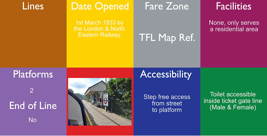
West Finchley is a London Underground station in the Finchley area of the London Borough of Barnet. The station is on the High Barnet branch of the Northern line between Finchley Central and Woodside Park stations and is in Travelcard Zone 4.
The station was opened by the London & North Eastern Railway (LNER) on 1st March 1933 on its line to High Barnet. It opened to serve new housing developing in the area and was built with only modest station structures from the outset.
Many fittings were taken from stations in the north of England. The platforms here are open air.

West Ham is a London Underground, Docklands Light Railway (DLR) and National Rail intermodal interchange station in West Ham, London, United Kingdom. The station is served by London Underground District, Hammersmith & City and Jubilee lines, the Stratford International branch of the DLR and c2c National Rail services.
Key dates:
1st February 1901 - Opened (LT&SR / NLR), 1902 - District line started, 1913 the London–Southend service was withdrawn,
1st January 1916 - NLR withdrawn, 1936 Hammersmith & City services started, 14th May 1979 North London service started,
14th May 1999 c2c and Jubilee line started, 9th December 2006 the North London service was withdrawn, 31st August 2011 DLR services started. This station is not the closest for West Ham stadium - use
The station is in London fare zone 2 and zone 3. This station has had extensive redevelopment over the years and now has 8 platforms (all open air), which consists of 4 islands - 1 for DLR, 1 for Jubilee, 1 for Mainline, 1 for District and there is step free access to all platforms.

There are 3 physical stations all called West Hampstead - this is for the Jubilee line station and is about a 200 yard walk from Thameslink station. There has been a proposal to have an interchange link built.
West Hampstead is a London Underground Jubilee line station in West Hampstead. It is located on West End Lane between Broadhurst Gardens and Blackburn Road and is situated in Travelcard Zone 2. It lies between Kilburn and Finchley Road tube stations. It is 100 m (110 yd) from West Hampstead station on the London Overground North London Line and 200 m (220 yd) from West Hampstead Thameslink station. Metropolitan line trains also pass through the station, but do not usually stop.
The station was opened on 30th June 1879 by the Metropolitan Railway (now the Metropolitan line) when it extended its tracks from Swiss Cottage. The station acted as the temporary terminus of the branch until it was further extended to Willesden Green on 24th November that year. On 20th November 1939, most stopping services were transferred to the Bakerloo line when it took over operations on the Stanmore branch.
If you are travelling north, it may be quicker to go south to Finchley Road and then use the Metropolitan line.
The platforms here are open air.

Image from https://www.ianvisits.co.uk/articles/west-hampstead-overground-station-upgrade-completed-34613/
There are 3 physical stations all called West Hampstead - this is for the Overground station and is about a 100 yard walk from Thameslink station.
West Hampstead railway station is a London Overground station on the North London Line between Brondesbury and Finchley Road & Frognal in the London Borough of Camden and is in Travelcard Zone 2.
The station and all trains are operated by London Overground.
The station opened on 1st March 1888 and was called West End Lane until 1975, when it became West Hampstead (making it one of three stations of essentially the same name along West End Lane). The train service was provided by the North London Railway until 1909, when management of the NLR was taken over by the London and North Western Railway. Complete amalgamation with the LNWR followed in 1922, and the LNWR then amalgamated with other railways to form the LMS from January 1923.
If you travel East from here and you go over the Thameslink line, go West from here and you go under the underground line, even though the lines at the stations are almost at the same height! The platforms here are open air.
The National Rail information for this station can be found here.

There are 3 physical stations all called West Hampstead - this is for the Thameslink station.
West Hampstead Thameslink is a National Rail station on the Midland Main Line and is served by Thameslink trains as part of the Thameslink route between Kentish Town and Cricklewood. The station is in Travelcard Zone 2.
The station was built by the Midland Railway on its extension to St. Pancras, to serve the newly developed area around the hamlet
of West End. It opened on 1st March 1871, and was originally named West End for Kilburn and Hampstead.
For a short period from 1878 the station formed part of the Super Outer Circle, Midland trains running through from
St. Pancras to Earl's Court via Acton Central and Turnham Green.
It was renamed several times: to West End on 1st July 1903; to West End and Brondesbury on 1st April 1904; to West Hampstead on 1st September 1905; West Hampstead Midland on 25 September 1950; and finally West Hampstead Thameslink on 16 May 1988. It was popular for many years for people taking a day out on Hampstead Heath and those visiting the chalybeate springs in Hampstead itself. The National Rail information for this station can be found here.
The platforms here are open air.

West Harrow is a London Underground station in Harrow in north west London.
The station is on the Uxbridge branch of the Metropolitan line, between Rayners Lane and Harrow-on-the-Hill stations, and in Travelcard Zone 5. It is the only station on the Uxbridge branch to be served exclusively by the Metropolitan.
The Metropolitan (Harrow and Uxbridge Railway) line passed through here between Harrow-on-the-Hill and Ruislip, with services beginning on 4 July 1904. West Harrow station opened on 17 November 1913. The platforms here are open air.

West India Quay is a Docklands Light Railway (DLR) station in Canary Wharf’s West India Quay. It is located at the point where the line from Lewisham splits into branches to Tower Gateway/Bank and Stratford. The next stations on each line are Canary Wharf DLR station (to Lewisham), Westferry (to Tower Gateway/Bank) and Poplar DLR station (to Stratford). The station is in Travelcard Zone 2.
The station opened in 1987 but was closed from 1991 to 1993 as the surrounding area was rebuilt. The station is near to the Museum in Docklands and the adjoining hotel and leisure facilities on the north quay of West India Docks, and indeed the platforms of the station extend over part of the dock. The station was originally built with 4 platforms, but has been redevleoped and has now only got 3 and they are numbered 2,3,4. The platforms are covered with a canopy and are elevated above street level.
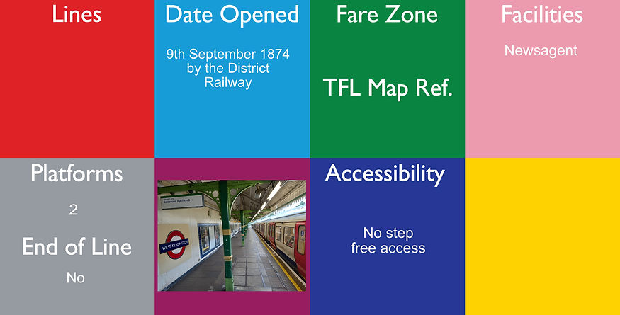
West Kensington is a London Underground District line station in West Kensington. It is located on North End Road (B317) close to its junction with West Cromwell Road/Talgarth Road (A4).
The station is between Earl's Court and Barons Court and is in Travelcard Zone 2.
The station is situated in a cutting with the ticket office at street level. The station was opened by the District Railway (DR, now the District line) on 9th September 1874 as 'North End (Fulham)' It was renamed West Kensington in 1877.
On 5 May 1878, The Midland Railway began running a circuitous service known as the "Super Outer Circle" from St Pancras to Earl's Court via Cricklewood and South Acton. It operated over a now disused connection between the NLR and the London and South Western Railway's branch to Richmond (now part of the District line). The service was not a success and was ended on 30th September 1880.
The entrance building was rebuilt in 1927. The design, by Charles Holden, uses similar materials and finishes to those Holden used for the Northern line's Morden extension opened in 1926.
The platforms here are open air and at the far end of the eastbound platform there is gate for staff use, which leads to 'Ashfield House'

2 for Underground
2 for Mainline
West Ruislip is a station on Ickenham High Road on the borders of Ickenham and western Ruislip in the London Borough of Hillingdon in Greater London, formerly in Middlesex. It is served by London Underground (LU) and National Rail trains on independent platforms. It is the western terminus of the Central line's West Ruislip branch; Ruislip Gardens is the next Underground station towards central London. The Central line and Chiltern Railways platforms and ticket office hall are managed by LU. The closest station on the Metropolitan and Piccadilly lines is Ickenham, 1.1 miles (1.8 km) from West Ruislip Station.
The station was opened on 2 April 1906 as Ruislip & Ickenham by the Great Western and Great Central Joint Railway (GW&GCJR).
The Central line services commenced 21st November 1948.
The National Rail information for this station can be found here.
The platforms here are open air. This is the terminus for the Underground. Ruislip depot is close by to here and the tracks here are connected to the Mainline just north of the platforms, where new trains can be delivered.
If you are heading into central London, it is normally quicker to get a National Rail service to Marylebone from here
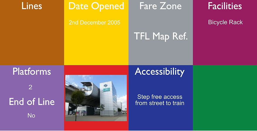
West Silvertown is a Docklands Light Railway (DLR) station in Silvertown which opened in December 2005. It is located on the Woolwich Arsenal branch. Trains run Westbound to Bank in the City of London and Eastbound to Woolwich Arsenal, passing through London City Airport station.
The station is in the London Borough of Newham and is located in Travelcard Zone 3.
Prior to December 2005, Docklands Light Railway trains would arrive at Canning Town and would only be able to continue in a South-Easterly direction towards Royal Victoria. In December 2005, however, the new King George V branch was opened.
The platforms are open air and are eleveated above the road.

West Sutton railway station is in the London Borough of Sutton in South London, England. The station is served by Thameslink trains on the Sutton Loop Line. It is in Travelcard Zone 5.
Parliamentary approval for a line from Wimbledon to Sutton had been obtained by the Wimbledon and Sutton Railway (W&SR) in 1910 but work had been delayed by World War I. From the W&SR's inception, the District Railway (DR) was a shareholder of the company and had rights to run trains over the line when built.
The National Rail information for this station can be found here.
The platform here is an island platform, serving 2 lines and is partially covered.
There are only 2 trains per hour in both directions, so check times before travel.

Westbourne Park is a London Underground station in the Notting Hill area of the Royal Borough of Kensington and Chelsea. It is on the Circle and Hammersmith and City lines, between Ladbroke Grove and Royal Oak stations, and is in Travelcard Zone 2.
Although the Metropolitan Railway (MR) had been extended to Notting Hill and Hammersmith on 1st June 1864, the first station by this name did not open until 1st February 1866. In 1867, with the companies on better terms, the MR bought a share of the Hammersmith & City Railway (H&CR) from the Great Western Railway (GWR), after which it eliminated the broad gauge track and operated almost all the trains (the H&CR's identity being effectively lost).
The original station closed on 31st October 1871, and was replaced the following day by a new station, constructed to the west of the original. To remove this traffic from its own busy main line, the GWR built a new pair of tracks from Paddington to Westbourne Park, and on 12th May 1878 it opened a "dive-under".
The platforms here are open air and there is a large gate at the side of one of the platforms that is only used for the Notting Hill Carnival.

Westcombe Park station is in Greenwich, London, and is situated on the Greenwich Line connecting suburbs (e.g.: Deptford, Greenwich, Charlton, Woolwich, to Dartford, Kent) along the south side of the River Thames with central London stations (London Bridge, Cannon Street and Charing Cross).
It is 5 miles 7 chains (8.2 km) down the line from London Bridge. The station was opened by the South Eastern Railway in 1879, the year after the through line from Greenwich to Maze Hill was finally completed.
The National Rail information for this station can be found here.
The platforms here are open air and to change platforms step free, you need to use a road, which is not a short walk

Westferry is a station on the Docklands Light Railway (DLR), at the junction of Limehouse Causeway and Westferry Road in Limehouse in London Docklands, England. The station is located in Travelcard Zone 2. To the west is Limehouse station, whilst to the east the DLR splits, with one branch going to Poplar station and the other to West India Quay station. The DLR station was built midway between the site of the old Limehouse and West India Docks stations on the disused London and Blackwall Railway.
The platforms here are partially covered and are elevated above street level.
Jubilee - step free access from street to train
Circle/District step free access from street to platform
2 for the Circle / District
2 for the Jubilee
Westminster is a London Underground station in the City of Westminster. It is served by the Circle, District and Jubilee lines. On the Circle and District lines, the station is between St James's Park and Embankment, and on the Jubilee line it is between Green Park and Waterloo. It is in Travelcard Zone 1. The station is located at the corner of Bridge Street and Victoria Embankment and is close to the Houses of Parliament, Westminster Abbey, Parliament Square, Whitehall, Westminster Bridge, and the London Eye.
The station is in two parts: sub-surface platforms opened in 1868 by the District Railway (DR) as part of the company's first section of the Inner Circle route and deep level platforms opened 20th November 1999 as part of the Jubilee line extension from Green Park to Stratford. A variety of underground and main line services have operated over the sub-surface tracks, but the original station was completely rebuilt in conjunction with the construction of the deep level platforms and Portcullis House, which sits above the station.
It was known as Westminster Bridge from 1868–1907.
The Jubilee line platforms are about 33 metres underground and the Circle / District lines are about 5.6 metres underground (NB - this is not shown on the diagram, but based on Embankment is is about 5.5 metres and St. James's Park is 5.8 metres)
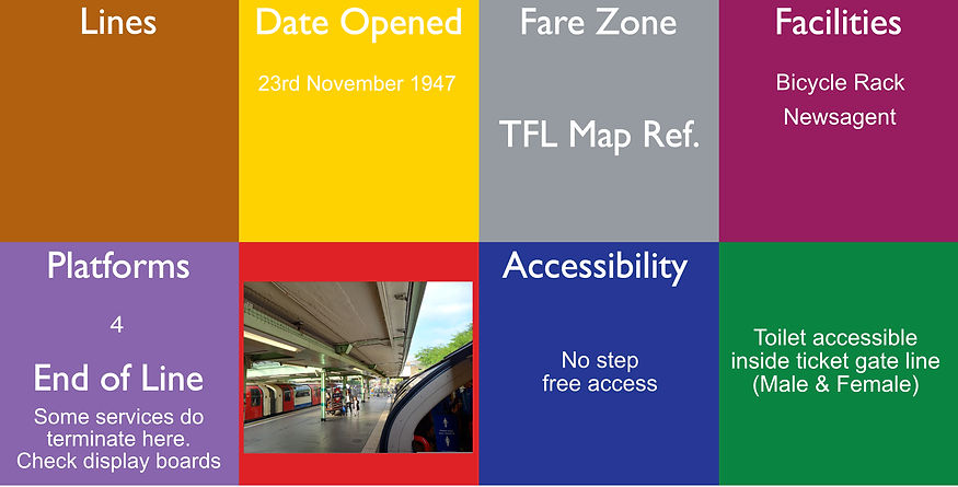
White City is a London Underground station on Wood Lane in White City, west London, England, on the Central line between Shepherds Bush and East Acton stations in Travelcard Zone 2. The station is in a deep brick-sided cutting - and is designed in a similar way to Harrow-on-the-Hill station.
The station was opened on 23rd November 1947, replacing the earlier Wood Lane station. Its construction started after 1938 and had been scheduled for completion by 1940, but the Second World War delayed its opening for another seven years. The architectural design of the station won an award at the Festival of Britain and a commemorative plaque recording this is attached to the building to the left of the main entrance. The platforms feel like they are underground because the station is built in a cuting and has a high glass roof.
This station is within a short walking distance from the Westfield shopping centre. This station has access to the White City depot to the south and it has the unique feature of both "right hand running" and a "Spanish Solution" platform.

White Hart Lane is a London Overground station on the Lea Valley lines located in Tottenham of the London Borough of Haringey in North London. It is 7 miles 11 chains (11.5 km) from London Liverpool Street and is situated between Bruce Grove and Silver Street. It is in Travelcard zone 3.
White Hart Lane was originally a stop on the Stoke Newington & Edmonton Railway line (part of Great Eastern Railway) which opened on 22nd July 1872. The original station building is a two-storey brick structure. As part of the Northumberland Development Project to redevelop the White Hart Lane stadium and regenerate the area the station was also selected to be upgraded. This involved the building of a new ticket hall to the south of the original station building. A second entrance was built in 1962 and a new building was completed in 2019, which included lifts for step free access.
The National Rail information for this station can be found here.
The is the the closest station for the White Hart Lane (Tottenham Hotspurs) football ground.
The platforms here are open air and are on a viaduct.

Whitechapel (there is a Bengali sign at the station: হোয়াইটচ্যাপেল) is a London Underground and London Overground station located on Whitechapel Road and Durward Street in the Whitechapel area of London, United Kingdom. The station is located behind a street market of the same name and opposite the Royal London Hospital. It lies between Aldgate East and Stepney Green stations on the District and Hammersmith & City lines, and between Shoreditch High Street and Shadwell stations on the East London Line. and between Liverpool Street and Stratford / Canary Wharf on the Elizabeth line. It is in Travelcard Zone 2.
The station was comprehensively rebuilt in the late 2010s and early 2020s as part of the Crossrail project.
The Elizabeth line services commenced 24th May 2022. The National Rail information for this station can be found here
Whitechapel station was originally opened in 1876 by the East London Railway (ELR) as Whitechapel (Mile End): 1884–1901.
On 6th October 1884, the District Railway (DR, now the District line) opened a new station adjacent to the deeper ELR station as the terminus of an extension from Mansion House (part of the extension also formed the final section of the Circle line. The new station was given the name "Whitechapel (Mile End)".
Over the years, this station has undergone extensive redevelopment and when the Underground platforms were built, it had 4 platforms, as seen here, but now only has 2 (now numbered 1 & 2) and the Overground lines (platforms still numbered 5 & 6 - at about 7.6 metres underground) run underneath the Underground at about 3.1 metres underground and the Elizabeth lines (Numbered A & B) run beneath both at about 30 metres.

Willesden Green is a London Underground station on Walm Lane in Willesden. It is served by the Jubilee line and is between Dollis Hill and Kilburn. Metropolitan line trains also pass through the station, but do not usually stop.
The station is in both Travelcard Zone 2 and Zone 3.
The station opened on 24th November 1879 on the Metropolitan Railway (later the Metropolitan line). From 1894 to 1938 it was known as "Willesden Green and Cricklewood". From 20th November 1939 it also served the Stanmore branch of the Bakerloo line, with Met services being withdrawn the following year. It transferred to the Jubilee line in 1979. A connecting tunnel at Embankment tube station mistakenly shows Willesden Green as part of the Bakerloo line as a result of a typo which instead should say Willesden Junction. This can be found on a printed map on the wall of Embankment station. This station is a listed building.
The platforms here are open air, even though the station has 4 platforms, only 2 are used by the Jubilee services, however the Metropolitan services can stop in an emergency. The external building still has the letters "M.R" on the outside.

Willesden Junction is a National Rail station in Harlesden, north-west London, UK. It is served by both London Overground and London Underground services.
The station developed on three contiguous sites: the West Coast Main Line (WCML) station was opened by the London & North Western Railway on 1 September 1866 to replace the London and Birmingham Railway's Willesden station of 1841 which was 0.5 miles (0.80 km) to the northwest. Passenger services ended in 1962 when the platforms were removed during the electrification of the WCML to allow the curvature of the tracks to be eased. Later the bridges for the North London Line (NLL) were rebuilt. This station is on 2 levels, as this is the only way that lines can cross and still have platforms to the various lines and the main Traction Maintenance Depot (TMD) is just outside this station.
The National Rail information for this station can be found here. and the platforms are all open air. Bakerloo services only stop at platforms 1 & 3
More photos can be seen at: https://tubemapper.com/willesden-junction-station/

Yes - District line
& Trams
Wimbledon is a National Rail, London Underground, and Tramlink station located on Wimbledon Bridge, and is the only station in London that provides an interchange between the London Underground and Tramlink. The station serves as a junction for services from the Underground's District line and National Rail operators (South Western Railway and Thameslink), as well as Tramlink services. Some weekday peak services on the Thameslink route are provided by Southern. The station is in Travelcard Zone 3.
It is 7 miles 19 chains (11.6 km) from London Waterloo on the South West Main Line.
The station has 11 platforms. Platforms 1–4 are for London Underground, platforms 5 & 8 are for inner suburban South Western Railway services, platform 9 is for Thameslink and platforms 10a/b are for Tramlink. Platforms 6 & 7 are adjacent to the fast tracks intended for express and outer suburban South Western Railway services,
The first railway station in Wimbledon was opened on 21st May 1838, when the London and South Western Railway (L&SWR) opened its line from its terminus at Nine Elms in Battersea to Woking. The original station was to the south of the current station on the opposite side of the Wimbledon Bridge. On 22nd October 1855, the Wimbledon and Croydon Railway (W&CR) opened the West Croydon to Wimbledon Line to West Croydon via Mitcham The trams were introduced here 10th May 2000 and the platforms are almost in line with the previous railway line.
This is NOT the closest station for the tennis at Wimbledon - Southfields is, but this works well as an interchange betweemn Tram/ Mainline and Underground.
The National Rail information for this station can be found here.

Wimbledon Chase railway station is in the London Borough of Merton in South London. The station is served by Thameslink trains on the Sutton Loop Line. It is in Travelcard Zone 3 and is arranged as an island eight-car platform, with stairs descending to street level towards the southern end.
The National Rail information for this station can be found here.
The District Railway (DR) was a shareholder of the company (Wimbledon and Sutton Railway) and had rights to run trains over the line when built. In the 1920s and it was originally planned that the District line would run through here, but this never happened.
The platform is an island with running rails either side and is open air.

Wimbledon Park is a London Underground station in Wimbledon. The station is on the District line and is between Southfields and Wimbledon stations. The station is located on Arthur Road close to the junction with Melrose Avenue close to the eastern side of Wimbledon Park and is in Travelcard Zone 3. The station was opened by the District Railway (DR, now the District line) on 3rd June 1889 on an extension from Putney Bridge to Wimbledon. The extension was built by the London and South Western Railway (L&SWR) which, starting on 1st July 1889, ran its own trains over the line from a connection at East Putney to its Clapham Junction to Barnes line.
The section of the District line from Putney Bridge to Wimbledon was the last part of the line to be converted from steam operation to electric. Electric trains began running on 27th August 1905. Main line services through Wimbledon Park ended on 4th May 1941.
Wimbledon Park Depot is located here.
The platform is an island platform and is open air.

Wood Green is a London Underground station on the Piccadilly line. The station is between Turnpike Lane and Bounds Green stations and is in Travelcard Zone 3. It is located at thejunction of High Road, Wood Green and Lordship Lane. It serves Wood Green Shopping City and the nearby Haringey Council administrative complex as well as a densely populated residential area. It is also the closest tube station to Alexandra Palace. The station opened on 19 September 1932 when the first section of the Cockfosters extension from Finsbury Park was opened and it was built to fit into a corner site within an existing parade of shops.
On the northern side, the structure also incorporates a shop which forms part of the parade in High Road. The other end of the parade features a large London Underground substation.
To the north of the station is a reversing siding. This was used for reversing northbound trains so that they could return towards central London and Heathrow Airport or Uxbridge. Until the 1990s trains were regularly turned back here - trains now only reverse at Wood Green in times of service disruption, or to regain time after late running. This station is now a listed building.
The platforms here are about 12.8 metres underground.

For the closed station that was on the Metropolitan line, see Wood Lane tube station (Metropolitan line). For the closed station that was on the Central line, see Wood Lane tube station (Central line). See also: Stations around Shepherd's Bush
Wood Lane is a London Underground station in the White City area of west London, United Kingdom. It is on the Circle and Hammersmith & City lines, between Latimer Road and Shepherd's Bush Market stations, in Travelcard Zone 2.
Although it is on a line which has been in operation since 1864, the station is new, having opened on 12th October 2008 – the first station to be built on an existing Tube line for over 70 years. It is near the site of a station of the same name that closed on 24th October 1959.
In 2005, work commenced on the large-scale Westfield Shopping Centre. As part of the work, £200m of transport improvements were made including rebuilding Shepherd's Bush Central line station, a new Shepherd's Bush railway station and two bus interchanges. It was decided to build a new station on the Hammersmith & City line, just north-east of the old Metropolitan station on Wood Lane. In 2006 Transport for London decided, after deliberating over various possibilities, on the name Wood Lane, reviving an historical name. This was the first time that a new station on the Tube had been given the name of a former station that had been closed for several years.
The station opened on 12th October 2008. On 13th December 2009 Wood Lane was added to the Circle line when the line was extended to Hammersmith.
The platforms are open air and are on a viaduct above the road

Image from https://www.geograph.org.uk/photo/4149059
Wood Street is a railway station on the Chingford branch of the Lea Valley lines, located in Upper Walthamstow in the London Borough of Waltham Forest, east London. It is 7 miles 7 chains (11.4 km) down the line from London Liverpool Street and is situated between Walthamstow Central and Highams Park. It has been operated by London Overground since 2015.
It is also occasionally known as "Walthamstow Wood Street". The station is in Travelcard Zone 4.
The station was opened in 1873 by the Great Eastern Railway.
When construction of the London Underground Victoria line was given parliamentary approval in 1955, the plan was to build the line past Walthamstow Central station to Wood Street, where the line would surface to terminate next to the British Railways station, on land previously used as a coal depot. Before construction work started, a decision was made in 1961 to omit the section beyond Walthamstow Central.
The National rail information for this station can be found here. The platforms are open air and are elevated above a road on a viaduct.

Woodford is a London Underground station in the town of Woodford in the London Borough of Redbridge, East London. The station is on the Central line, between South Woodford and Buckhurst Hill stations and is in Travelcard Zone 4. The station also acts as a terminus for services via the Hainault loop. The station was originally opened on 22nd August 1856 as part of the Eastern Counties Railway branch from Leyton to Loughton. The Central line services commenced 14th December 1947.
The platforms here are open air and there are stabling sidings here.
More photos can be seen at: https://tubemapper.com/woodford-station/

Image from https://www.geograph.org.uk/photo/1783296
Woodgrange Park railway station is a London Overground station on Romford Road in Manor Park in the London Borough of Newham, east London. It is the penultimate station on the Gospel Oak to Barking line (GOBLIN), 12 miles 1 chain (19.3 km) down the line from Gospel Oak; it lies in Travelcard Zones 3 and 4. The station is managed by London Overground, which also provides all train services. It has only limited station buildings and facilities, and as of October 2019 was the 9th least-used railway station in Greater London.
The tracks were laid through the site in 1854 as part of the first section of the London, Tilbury and Southend Railway, from Forest Gate Junction on the Eastern Counties Railway to Barking.
During 1964 the street level station buildings were demolished and replaced by a new structure and the platform buildings were demolished and replaced by shelters c1976. At this time the station was little used.
The national Rail information for this station can be found here. The platforms here are open air.

Woodside tram stop is a light rail stop situated between Woodside Green and Ashburton Park in the London Borough of Croydon in the southern suburbs of London. The stop is located on the site of the former Woodside railway station of the Woodside and South Croydon Railway; the old station buildings survive, though not used by Tramlink.
The tram stop has open air platforms on each side of the track with access to both platforms by stairs on the west side of the station building and by ramps on the east side and a level crossing.
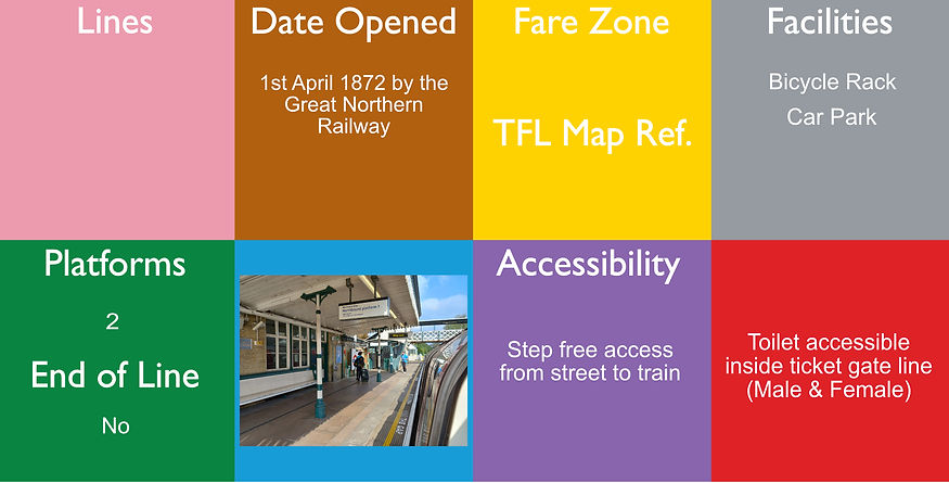
Woodside Park is a London Underground station in Woodside Park, north London.
The station is on the High Barnet branch of the Northern line, between West Finchley and Totteridge and Whetstone stations, and in Travelcard Zone 4. It was planned by the Edgware, Highgate and London Railway (EH&LR) and was originally opened as Torrington Park on 1st April 1872 by the Great Northern Railway (which had taken over the EH&LR). The station was on a branch of a line that ran from Finsbury Park to Edgware via Highgate. The station was renamed within a month of opening, and again in 1882.
(Torrington Park, Woodside: 1872–82, Woodside Park for North Finchley: 1882–1931, Woodside Park and North Finchley for Woodside Garden Suburb: 1931–40.
The platforms here are open air. It has step free access to both platforms, but not in between platforms, this has to be done by road and it is quite a distance between the 2.

Woolwich railway station was built as part of the Crossrail rail project to provide infrastructure for the Elizabeth line. Crossrail was jointly sponsored by the Department for Transport (DfT) and Transport for London (TfL).[5] The construction of a station at Woolwich was not proposed as part of the original Crossrail route. However, after talks between Greenwich London Borough Council and developer Berkeley Homes about the £162 million required for the station, the House of Commons Select Committee recognised its inclusion in March 2007. This station is a short walk away from the DLR Woolwich Arsenal station.
The platforms are underground here.

Yes - for the DLR only
Woolwich Arsenal station is a National Rail and Docklands Light Railway (DLR) paired interchange station in the heart of Woolwich in the Royal Borough of Greenwich. It has two parts; its raised, south-western part of the station is on the semi-slow, commuter service, corollary of the North Kent Line and also in its Dartford Loop services section between London and Dartford, run by Southeastern. Regular services beyond Dartford are to the Medway Towns, which start/finish in the opposite direction at Luton via the City of London, West Hampstead and St Albans. Its other part is the terminus of its own branch of the DLR, run by Transport for London.
The station opened in 1849, serving the North Kent Line from London to Gillingham. The station building was rebuilt in 1906 in a London brick form typical of southeast London. It was again rebuilt in 1992–93 to a modern design in steel and glass by the Architecture and Design Group of British Rail, under the leadership of Nick Derbyshire.
The DLR part of the station opened 10th January 2009.
The National Rail information for this station can be found here.
Although there are 2 external buildings next to each other, both lines can be accessed from either external building. The platforms are all partially covered by buildings above.