
Background photo taken at Tooting Bec

Taplow railway station serves the village of Taplow in Buckinghamshire, England. It is 22 miles 39 chains (36.2 km) down the line from London Paddington and is situated between Burnham to the east and Maidenhead to the west.
The station has been served by local services operated by TfL Rail since December 2019. The first station was opened on 4 June 1838 as Maidenhead (referred to as Maidenhead Riverside in some publications). The station was the terminus of the Great Western Railway for just over a year until the opening of Maidenhead Railway Bridge and the line to Twyford on 1 July 1839. The station was renamed Maidenhead and Taplow in August 1854. The National Rail information for this station can be found here.
The services here were transferred to the Elizabeth line on 24th May 2022. The platforms here are open air.

Temple is a London Underground station located at Victoria Embankment in the City of Westminster, close to its boundary with the City of London. It is on the Circle and District lines between Embankment and Blackfriars, and is in fare zone 1.
The station was opened on 30 May 1870 with the name The Temple, from the Temple area in the vicinity of Temple Church, and from the Inner Temple and the Middle Temple, two of the four Inns of Court of London. The Temple station was opened in the parish of St. Clement Danes on 30 May 1870 by the District Railway
In Victoria Embankment Gardens there is a ventilation shaft where the trains are visible. There is a preserved heritage map outside the station entrance
The platforms are about 3.5 metres underground.

Theobalds Grove is a London Overground station on the Southbury Loop section of the Lea Valley lines, located in Waltham Cross, Hertfordshire. The station is named after the nearby Theobalds Palace grounds. It is 13 miles 45 chains (21.8 km) down the line from London Liverpool Street and is situated between Turkey Street and Cheshunt, the northern terminus.
The station is in Travelcard Zone 7. The railway line from Bury Street Junction, north of the current Edmonton Green station, to Cheshunt was opened by the Great Eastern Railway on 1 October 1891. It was known as the Churchbury Loop, it then closed 1st October 1909 and reopened 1st March 1915. It then closed again 1st July 1919 and reopened 21st November 1960.
The National Rail information for this station can be found here. The platforms here are open air.

Therapia Lane tram stop is a stop on the Tramlink service in Croydon, close to the Purley Way commercial area. The stop is in the London Borough of Sutton close to the boundary with Croydon. It is one of two Tramlink stops within Sutton borough, the other being Beddington Lane.
Just to the west of the stop is Therapia Lane Depot Staff Halt, a two platform stop used only by staff getting to or from Therapia Lane depot, and not permitted for public use. The platforms here are open air.

Theydon Bois is a London Underground station in the village of Theydon Bois in Essex, England. It is served by the Central line and is between Debden and Epping. For the purposes of fare charging it is in Zone 6.
The station was opened as "Theydon" by the Great Eastern Railway (GER) on 24 April 1865 but in December that year it was renamed to its present name. It opened as an intermediate station on their Loughton–Ongar extension; the GER became part of the London and North Eastern Railway (LNER) in 1923. 'Milk trains' to Liverpool Street were a regular feature in the timetable until the underpass from Leyton to Stratford was built.
As part of the New Works Programme, 1935–1940, the LNER branch was transferred to London Underground, to form the part of the eastern extension of the Central line. The platforms here are open air.
More photos can be seen at: https://tubemapper.com/theydon-bois-station/

Tooting is a railway station serving Tooting in South London; it is within Travelcard Zone 3. Although Tooting is in the London Borough of Wandsworth, the station is located just across the borough boundary in the neighbouring London Borough of Merton. The station is on the Sutton Loop Line and is served by Thameslink trains and by a limited number of Southern services during the morning and evening peak.
The station opened in 1894 as Tooting Junction, replacing an earlier station of the same name, which was located a few hundred yards west and had opened in 1868. It was renamed Tooting in 1938, following the closure of the branch line from Tooting to Merton Park to passenger traffic in 1929. The National Rail information for this station can be found here. The platforms here are open air.
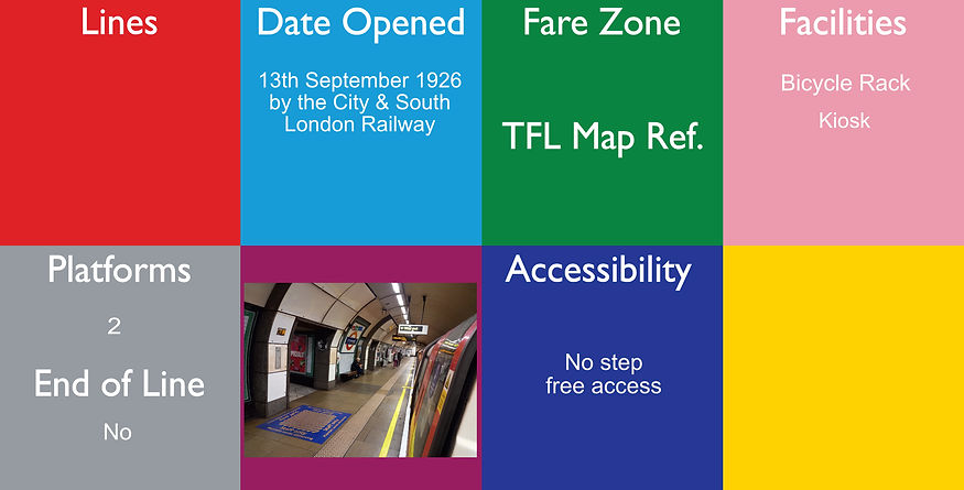
Tooting Bec, originally Trinity Road (Tooting Bec), is a London Underground station in Tooting, South London. The station is on the Northern line, between Balham and Tooting Broadway stations. It is located on the junction of Trinity Road (heading north-west), Upper Tooting Road (south-west), Balham High Road (north-east), Tooting Bec Road (south-east) and Stapleton Road (also south-east). The station is in Travelcard Zone 3.
The station was designed by Charles Holden and opened on 13 September 1926 as part of the Morden extension of the City & South London Railway, which is now part of the Northern line. Originally known as Trinity Road (Tooting Bec), i and t was given its present name on 1 October 1950 and is now a listed building.
The platforms are about 15.9 metres underground.
The narrow satellite building on the east side of the junction provides pedestrian subway access to the station and is unusual in that it has a large glazed roundel on each of the three panels of its glazed screen, as normally the Modern extension stations have the roundel in just the centre panel.

Tooting Broadway is a London Underground station in Tooting in the London Borough of Wandsworth, South London. The station is on the Northern line, between Tooting Bec and Colliers Wood stations and is in Travelcard Zone 3.
The station is a Grade II listed building. Along with the other stations on the Morden extension, the building was designed by architect Charles Holden. They were Holden's first major project for the Underground. He was selected by Frank Pick, general manager of the Underground Electric Railways Company of London (UERL), to design the stations after he was dissatisfied with designs produced by the UERL's own architect, Stanley Heaps.
The platforms are about 12.5 metres underground. The big statue of Edward VII at the entrance was paid for entirely by the public when it was made in 1911
6 (2 for central
2 for Elizabeth
2 for Northern)
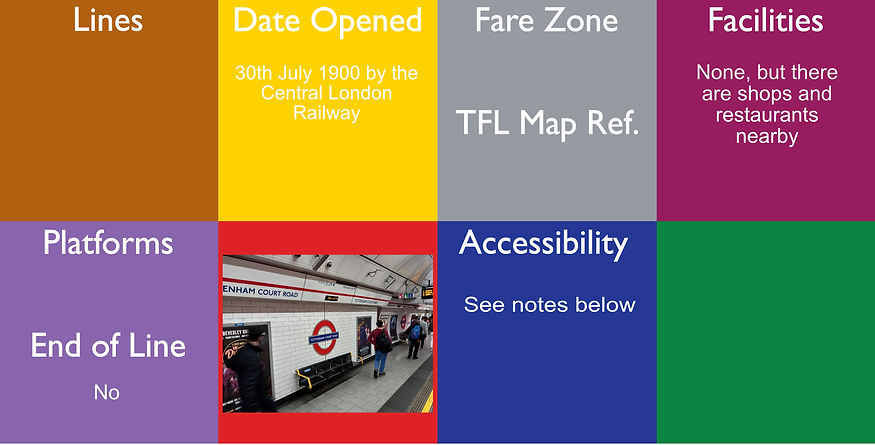
Tottenham Court Road is a London Underground station in St Giles in the West End of London. It is served by the Central line and the Charing Cross branch of the Northern line. The station will also be served by the Elizabeth line when the core section opens.
On the Central line it is between Oxford Circus and Holborn, and on the Northern line it is between Leicester Square and Goodge Street. The station is located at St Giles Circus, the junction of Tottenham Court Road, Oxford Street, New Oxford Street and Charing Cross Road and is in Travelcard Zone 1.
The station opened as part of the Central London Railway (CLR) on 30 July 1900. From that date until 24 September 1933, the next station eastbound on the Central line was the now-defunct British Museum; the next stop in that direction is now Holborn.
The Charing Cross, Euston & Hampstead Railway (CCE&HR, now part of the Northern line) arrived here on 22 June 1907 but used the name Oxford Street until 1908.
The Elizabeth line opened 24th May 2022. The National Rail information for this station can be found here.
Step free access: Central line is step free from street to platform and Elizabeth line and Northern line are both step free from Street to train.
The platforms are underground at about 26.2 metres (Central line), 29.8 metres (Northern line) and the Elizabeth line is deeper than the Northern line.
The original ticket office was directly beneath St Giles circus and was accessed from stairs on three street corners around the Circus. Its original lift shafts and emergency stairs are still extant. A set of emergency stairs can be used as access down to the ends of the Northern line platform. The lift shafts are used for offices and station facilities More photos can be seen at: https://tubemapper.com/tottenham-court-road-station/

5 (2 for Victoria
3 for Mainline)
Tottenham Hale is a National Rail and London Underground interchange station located in Tottenham Hale in north London, England. On the National Rail network it is on the West Anglia Main Line, 6 miles (9.7 km) from London Liverpool Street, and is served by Greater Anglia and Stansted Express. On the Underground it is on the Victoria line between Blackhorse Road and Seven Sisters. The station is in Travelcard Zone 3.
The station was opened in 1840, with Underground services added in 1st September1968. A new station building is under construction, and an additional platform is being added as part of a regeneration scheme.
The National Rail information for this station can be found here. The National Rail platforms are at street level and the Victoria lines are about 16.8 metres underground.
Tottenham Hale Bus garage is just outside the station.

Totteridge & Whetstone is a London Underground station in Whetstone in the London Borough of Barnet, North London. The station is the penultimate one on the High Barnet branch of the Northern line, between Woodside Park and High Barnet stations, in Travelcard Zone 4. It was first opened on 1st April 1872 by the Great Northern Railway as 'Totteridge' and was transferred on 14th April 1940 to the Northern line. LNER (previously the GNER) services ended in 1941. British Rail freight trains ran until 1st October 1962. The platforms here are open air.
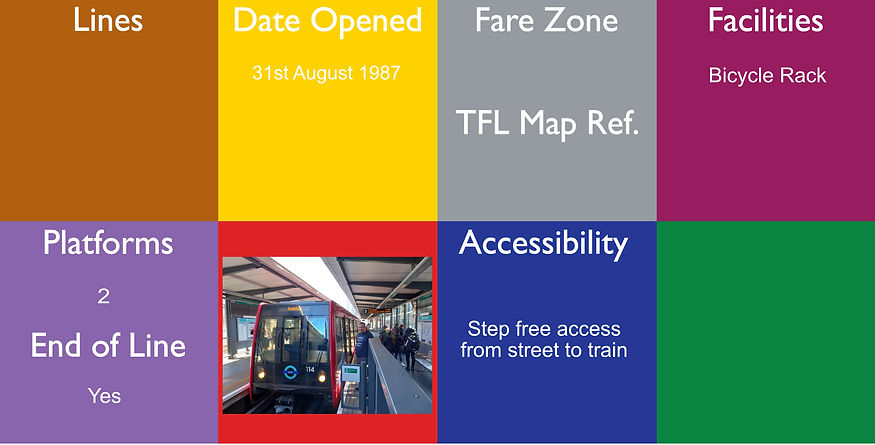
Tower Gateway is a Docklands Light Railway (DLR) station in the City of London and is located near the Tower of London and Tower Bridge. It adjoins the tracks to Fenchurch Street station and is located on the site of a former station called Minories. Tower Gateway is within London fare zone 1.
It is a short walk from both Tower Hill Underground station and Fenchurch Street. It was first opened 31st August 1987 as the western terminus of the initial DLR system and then closed 30th June 2008 for redevelopment and reopened 2nd March 2009. There are 2 platforms here with one track, so you would exit the train from one side and then enter from the other (this is also known as the "Spanish Solution"). The Thames Clipper service is also a short walk away. The platforms here are elevated above the road are covered with a canopy.

Tower Hill is a London Underground station in Tower Hill in the East End of London. It is on the Circle line between Monument and Aldgate stations, and the District line between Monument and Aldgate East. Tower Hill is within Travelcard zone 1 and is a short distance from Tower Gateway station for the Docklands Light Railway, Fenchurch Street station for National Rail mainline services, and Tower Millennium Pier for River Services.
The station was built on the site of the former Tower of London station that closed in 1884. The present Tower Hill station opened in 1967 and replaced a nearby station with the same name but which was originally called Mark Lane, that was slightly farther west. Although this is not a terminus station, some services can terminate here. The platforms are about 5.0 metres below ground. The platforms are slightly curved, so check where to stand on the platform for step free access.
If you stand on the eastern end of the westbound platform, and look up near the ceiling you’ll be able to see one of the longest stretches of the London Wall built by the Romans to surrounded the City of London still in existence. The station was built on the site of the former Tower of London station that closed in 1884.

Tufnell Park is a London Underground station in Islington, close to its boundary with Camden. It is located in the Tufnell Park neighbourhood. It is on the High Barnet branch of the Northern line, between Archway and Kentish Town, and in Travelcard Zone 2.
The station was opened on 22 June 1907 by the Charing Cross, Euston & Hampstead Railway. The building was designed by architect Leslie Green and the exterior features glazed terracotta (faïence) tiling, supplied by the Leeds Fireclay Company. Although close to Junction Road railway station on the Tottenham & Hampstead Junction Railway, there was never a physical connection between the two stations.
The station was modernised in 2004 by Tube Lines and was closed 8th June 2015 for a lift replacement and reopened 4th March 2016. Although there is a lift, there is no step free access.
The platforms are underground at about 22.0 metres (Northbound) and 25 metres (Southbound - the platforms are one above the other). There is a notice on the stairs that says there are 110 steps, but there are actually 116 steps!

Tulse Hill railway station is in the Tulse Hill area of the London Borough of Lambeth in south London, between railway bridges over the A205, South Circular Road and the A215, Norwood Road. It is 5 miles 2 chains (8.1 km) measured from London Victoria. At the moment, there are 4 open air platforms here, each long enough for 8 coaches.
It is served by both Southern and Thameslink, and it is in Travelcard Zone 3.
Tulse Hill station was opened in 1868 by the London, Brighton and South Coast Railway on their line from London Bridge. In 1869, this was joined by the London, Chatham and Dover Railway's "Metropolitan Extension" line to Holborn Viaduct. The LB&SCR's through line to Streatham and Wimbledon opened in 1871. The National Rail information for this station can be found here.

Image from https://www.accessable.co.uk/london-borough-of-enfield/access-guides/turkey-street-station
Turkey Street is a London Overground station on the Southbury Loop section of the Lea Valley lines, located in the Bullsmoor area to the north of Enfield in north London. It is 12 miles 16 chains (19.6 km) down the line from London Liverpool Street and is situated between Southbury and Theobalds Grove. The railway line from Bury Street Junction, north of the current Edmonton Green station, to Cheshunt was opened by the Great Eastern Railway on 1 October 1891. It was known as the Churchbury Loop. The station was opened as Forty Hill and did not gain its current name until 1960. The National Rail information for this station can be found here. The platforms here are open air.

Turnham Green is a London Underground station in Chiswick of the London Borough of Hounslow, west London. The station is served by the District and Piccadilly lines although currently *Piccadilly line trains normally stop at the station only at the beginning and end of the day, running through non-stop at other times*. To the east, District line trains stop at Stamford Brook and Piccadilly line trains stop at Hammersmith. To the west, District line trains run to either Chiswick Park or Gunnersbury and Piccadilly line trains stop at Acton Town.The station is in both Travelcard Zone 2 and Zone 3.
Turnham Green station was opened on 1 January 1869 by the London and South Western Railway (L&SWR) on a new branch line to Richmond built from the West London Joint Railway starting north of Addison Road station (now Kensington (Olympia)). The platforms are open air.
Key dates summary: 1st January 1869 Opened (L&SWR), 1870 GWR Started and Ended, 1st June 1877 Metropolitan (MR) and District (DR) services started, 5th May 1878 "Super Outer Circle" (Midland) started, 1st July 1879 Ealing Broadway branch (DR) Opened, 30th September 1880 "Super Outer Circle" Ended, 1st January 1894 (GWR), 31st December 1906 (MR) ended, 31st December 1910 (GWR) ended, 3rd June 1916 (L&SWR) ended, 23rd June 1963 (Piccadilly) started
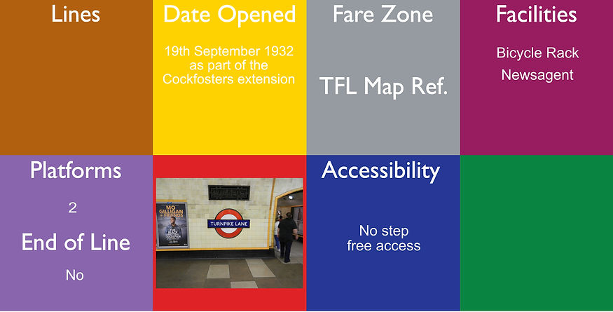
Turnpike Lane is a London Underground station at Turnpike Lane in the London Borough of Haringey in north London, England. The station is on the northeastern part of Piccadilly line between Manor House and Wood Green. The station was opened on 19 September 1932 as part of the Cockfosters extension. It is in Travelcard Zone 3. It was opened on 19 September 1932. It was the first Underground station in the Municipal Borough of Tottenham and was located at the meeting point of the boroughs of Tottenham, Hornsey and Wood Green, all now part of the London Borough of Haringey. The station was designed by the architect Charles Holden and is a well-preserved example of the modernist house style of London Transport in the 1930s. It was listed at Grade II in 1994. It was built as part of a shopping centre and featured a tower grafted on on one side. The ticket hall is an enormous brick box, with two large ventilation towers, half-sunk into the surrounding ground. Its high walls contain segmented windows that allow natural light to shine far into the station. The effect in late afternoon light is akin to that in a cathedral transept There was a proposed name of Ducketts Green/ North Harringay before opening. The booking Hall here is about 3.7 metres underground and the platforms are about 15.2 metres underground and there are "Daffodil uplighters" here.

Twyford railway station is a railway station in the large village of Twyford, in the English county of Berkshire.
The station is on the Great Western Main Line, 31 miles 1 chain (31.01 mi; 49.9 km) from the zero point at London Paddington. It is the junction station for the Henley-on-Thames branch, and is served by local services operated by Great Western Railway and TfL Rail.
The first Twyford station opened on 1 July 1839 and was the terminus of the GWR until 30 March 1840, pending the completion of Sonning Cutting. It was a timber building to the north of the line at right angles to the track. The Elizabeth line services commenced on 24th May 2022. The National Rail information for this station can be here.
The main entrance to the station, and main station building, are on platform 4 and serve the village centre. There is a second entrance on platform 1. There is a large car park between the main line and Henley branch and it is often full with morning commuters' cars. The platforms here are open air.

7 (1 for Overground, 3 for Underground, 3 for Mainline)
Upminster is an interchange station serving the town of Upminster in the London Borough of Havering, Greater London. It is on the London, Tilbury and Southend line (LTSR), 15 miles 20 chains (24.5 km) down the line from London Fenchurch Street; it is the eastern terminus of the District line on the London Underground; and it is the eastern terminus of the Romford to Upminster Line on the London Overground network. Upminster is the easternmost station on the London Underground network.
The station is managed by c2c, which operates the LTSR main line services. The station was opened in 1885 by the LTSR; its original entrance and structure beside the main line platforms survive from that date. A larger entrance and ticket hall on Station Road was built by the London, Midland and Scottish Railway in 1932 and has since been extensively modernised and includes a number of retail units. Today the station is owned by Network Rail. Upminster is located within Travelcard Zone 6. The National Rail information for this station can be found here. District line services commenced here 2nd June 1902, but were paused in 1905 and then reinstated in 1932. The platforms here are open air and partially covered with a canopy. Upminster depot for the District Line is just beyond the end of the line and is not visible from the station, but is visible by the mainline that continues on from here.
There is NO step free access to the Overground. To get to Romford from here, step free - use the bus.

Upminster Bridge is a London Underground station in the Upminster Bridge neighbourhood of Upminster in the London Borough of Havering, east London. It is on the District line between Hornchurch to the west and Upminster to the east. It is 1.2 kilometres (0.75 mi) along the line from the eastern terminus at Upminster and 33 kilometres (21 mi) to Earl's Court in central London where the line divides into numerous branches.
The station was opened on 17 December 1934 by the London, Midland and Scottish Railway on the local electrified tracks between Upminster and Barking that were constructed in 1932. The main station building, on Upminster Road, is of a distinctive polygonal design. District line service commenced 2nd June 1902. There are four tracks through the site although there are no platforms for the main lines. The full length of the platform is covered by a single canopy with a central waiting room.The Art Deco red brick ticket office is located below platform level, to which it is connected by a subway and stairway. The platforms are open air.

Upney is a London Underground station located on Upney Lane in Barking, east London. It is on the District line between Barking station to the west and Becontree station to the east. It is 10.96 kilometres (6.81 mi) along the line from the eastern terminus at Upminster and 23.24 kilometres (14.44 mi) to Earl's Court in central London where the line divides into numerous branches. It is in London fare zone 4.
The station was opened in 1932 by the London, Midland and Scottish Railway on the local electrified tracks that were extended to Upminster from Barking. The platforms are open air and partially covered with a canopy.

Upper Holloway railway station is in Holloway, north London (N19). It is on the Gospel Oak to Barking Line, 3 miles 0 chains (4.8 km) from St Pancras (measured via Kentish Town and Mortimer Street Junction) and is situated between Gospel Oak and Crouch Hill. It is operated by London Overground, and the service is one train every 15 minutes in each direction except late evenings when it is half-hourly. The line is now electrified, and services are operated by 4 car Class 710 EMUs.
The station is a short walk along Holloway Road from Archway on the Northern line. The National Rail information about this station can be found here. The platforms here are open air.

Upton Park is a London Underground station on the District and Hammersmith and City lines, on Green Street in the Upton Park area of the London Borough of Newham, east London. It is in Zone 3.
The station was opened by the London, Tilbury and Southend Railway (LTSR) in 1877. District line service began in 1902, and the Hammersmith & City (at that time the Metropolitan line) followed in 1936. LTSR services were withdrawn in 1962. The station has two working platforms, one for each direction. Two other platforms used to serve the LTSR but are now disused. The original building was demolished in 1903 and a new building was erected. On 2nd June 1902 - District services started and in1936 the Hammersmith & City services started. The platforms here are open air.

Uxbridge is a London Underground station in Uxbridge in the London Borough of Hillingdon, north-west London. The station is the terminus of the Uxbridge branches of both the Metropolitan line and the Piccadilly line. The next station towards London is Hillingdon. The station is 15.5 miles (25 km) west of Charing Cross and is in Travelcard Zone 6. Uxbridge was formerly the terminus of a branch of the District line which ran from Ealing Common; the Piccadilly line took over in 1933. The Harrow and Uxbridge Railway (later merged into the Metropolitan Railway) first opened a station in Uxbridge on 4 July 1904 on Belmont Road, a short distance to the north of the existing station. The existing building opened 4th December 1938, which is now a listed building.
There is a shopping centre right next to the station. The platforms are partially covered with a concrete canopy and this station is a mirror image of Cockfosters. On 23rd October 1933, the District line services to Uxbridge were replaced by Piccadilly services. There are 4 platforms facing three tracks, so one is a "Spanish Solution".

8 for the Mainline station.
2 for the Underground
Vauxhall is a National Rail, London Underground and London Buses interchange station in central London. It is at the Vauxhall Cross road junction opposite the southern approach to Vauxhall Bridge over the River Thames in the district of Vauxhall. The mainline station is run by the South Western Railway and is the first stop on the South West Main Line from London Waterloo towards Clapham Junction and the south-west. The Underground station is on the Victoria line and the station is close to St George Wharf Pier for river services.
The station was opened by the London and South Western Railway in 1848 as Vauxhall Bridge station. It was rebuilt in 1856 after a large fire, and given its current name in 1862. In the early 20th century, Vauxhall saw significant use as a stop for trains delivering milk from across the country into London. The Victoria line opened 23rd July 1971 as part of the Victoria line extension towards Brixton, while the bus station opened in 2004. The National Rail information for this station can be found here.
The Mainline platforms are above street level on a viaduct and the Victoria lines are about 17.5 metres underground.

2 for District/Circle
2 for Victoria
Image from https://www.ianvisits.co.uk/articles/major-victoria-tube-station-upgrade-opens-to-the-public-19843/
Victoria station, also known as London Victoria, is a central London railway terminus and connected London Underground station in Victoria, in the City of Westminster, managed by Network Rail. There are two connected Underground stations at Victoria, on different levels and built more than a century apart. The older one, on the north side of the bus station, serves the District and Circle lines, constructed by 'cut and cover' methods just below road level. The newer station, closer to the main line station, serves the Victoria line, a deep-level tube. Each has its own ticket hall, and the two are connected by a pedestrian passage beneath the bus station.
The first part of the station was opened on 24 December 1868 by the District Railway (DR, now the District line) when the company opened the first section of its line, between South Kensington and Westminster.
The Victoria line station opened on 7 March 1969, when the third phase of the line began operating, south of Warren Street. Victoria was the terminus while the final phase was under construction to Brixton. This opened on 23 July 1971.
The National Rail information for this station can be found here.