
Background photo taken at Kennington


Ickenham is a London Underground station located in Ickenham in the London Borough of Hillingdon. The station is on the Uxbridge branch of both the Metropolitan line and Piccadilly line, between Ruislip and Hillingdon stations.
The Metropolitan Railway (Harrow and Uxbridge Railway) constructed the line through Ickenham between Harrow on the Hill and Uxbridge and commenced services on 4 July 1904 with, initially, the only intermediate stop being at Ruislip. At first, services were operated by steam trains, but track electrification was completed in the subsequent months and electric trains began operating on 1 January 1905. The station was previously known as Ickenham Halt., the station was rebuilt into its present form between 1970 and 1971 replacing the 'halt' structures dating from 1905. The platforms are open air and the Metropolitan and Piccadilly lines are also linked at Ruislip depot, which branches off here.

20th June 1839 by the Eastern Counties Railway
Newsagent
4 (and 1 disused)
Bicycle Rack
Coffee Shop
Toilet accessible inside ticket gate line
(Male & Female & Disabled)
Step free access from street to platform, but not all entrances, details on National Rail website
Elizabeth line from 24th May 2022

No
Ilford railway station is on the Great Eastern Main Line serving the town of Ilford in the London Borough of Redbridge, east London. It is 7 miles 29 chains (11.8 km) down the line from London Liverpool Street and is situated between Manor Park and Seven Kings. Its three-letter station code is IFD and it is in Travelcard zone 4.
The station was opened in 1839 by the Eastern Counties Railway. It has previously been managed by TfL Rail, but is now managed by the Elizabeth line, step free access has only been available since August 2022, more information can be found here. The National Rail information about this station can be found here. The platforms here are open air.

27th September 2009
Bicycle Rack
Step free access from street to platform
2
No

Imperial Wharf is a London Overground and National Rail station located in Sands End in west London on the West London Line, and is next to Chelsea Harbour. The station is between West Brompton and Clapham Junction stations and services are provided by London Overground and Southern. The Thames Clipper is a short walk away from here. The National Rail information about this station can be found here. The platforms are elevated above a road and are ope air. There is not an overbridge here, so ensure that you enter through the correct gate side, if you are wrong, you will need to be let out by a staff member and then let back in.
The station opened on Sunday 27 September 2009 and is managed by London Overground.

Small convenience store close to the station (which was the original station before redevelopment)
31st August 1987
(see notes below)
2 - Island platform
Step free access
from street to train

No - but was
originally
Island Gardens is a Docklands Light Railway (DLR) station next to Island Gardens on the Isle of Dogs, East London. It is just north of the River Thames and is close to the southern tip of the Isle of Dogs and the River Thames.
Island Gardens is a public park with a notable view across the river to the classical buildings of the former Greenwich Hospital and the National Maritime Museum, with Greenwich Park forming a backdrop. The northern entrance of the Greenwich foot tunnel is within the park.
The original Island Gardens DLR station was opened on 31 August 1987 as the southern terminus of the initial system, this was peranently closed 8th January 1999 and then reopened in the current position 20th November 1999, with new platforms underground.
On 10 March 1987, before the system opened, a test train crashed through buffer stops at the original high-level Island Gardens terminus and was left hanging from the end of the elevated track. The accident was caused by unauthorised tests being run before the correct installation of the wayside safety system had been verified; an omission in the wayside system allowed the train to travel too fast on the approach to the terminus. The train was being driven manually at the time. As you come out of the station entrance, turn right and there is a car repair shop/MOT garage in the arches of the start of the lines to the original station. This is how the old station used to look.

Bicycle Rack
1st December 1924 by the Great Western Railway
4
Step free access from street to platform
Toilet accessible inside ticket gateline
(Disabled)
Elizabeth line from
24th May 2022
No

Iver railway station is situated in the village of Richings Park, near Iver, Buckinghamshire, England. It is the first station on the Great Western Main Line located outside Greater London, 14 miles 60 chains (23.7 km) down the line from London Paddington and is situated between West Drayton to the east and Langley to the west. The National rail information about this station can be found here.
In preparation for the introduction of Elizabeth line services, the operation of the station was transferred to MTR Crossrail on behalf of Transport for London at the end of 2017. The platforms here are open air.

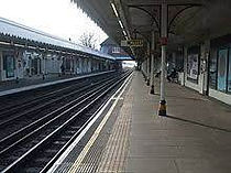
Kennington is a London Underground station on Kennington Park Road in Kennington within the London Borough of Southwark. The station is at the junction of the Charing Cross and Bank branches of the Northern line to the north and the Morden and Battersea Power Station branches to the south. Its neighbouring stations to the north are Waterloo on the Charing Cross branch and Elephant & Castle on the Bank branch; the next stations to the south are Oval and Nine Elms. The station is in both Travelcard Zones 1 and 2.
The station was opened in 1890 as part of the world's first underground electric railway and its surface building remains largely unaltered. In the 1920s, the underground parts of the station were reconstructed so that the line could be extended and larger trains could be used. Two additional platforms and later several cross passages were provided for interchanges between the branches. This station is now a listed building.
The high dome roof that can be seen from the outside, used to house the lift machinery, which was removed when escalators were installed. As this used to be a terminus, there is a loop of track, which now forms part of the extension to Battersea Power Station. Some service still terminate here and will go around the loop and back, so be careful not to fall asleep on the train. Geoff Marshall video can be seen here
The Northbound platform is about 17 metres underground and the Southbound platform is about 18.8 metres underground

Kensal Green is a Network Rail station served by London Underground Bakerloo line and London Overground trains. It is located in College Road, London NW10 close to the junction with Harrow Road. It is about 0.5 mile (750m) route distance from the older Kensal Rise station located to the north east on the North London Line, which was itself named Kensal Green until 1890. The station is in a cutting with a tunnel at the western end.
The station opened on 1 October 1916 on the new electrified Watford DC Line which runs parallel on the north side of the existing London and North Western Railway (LNWR) tracks from Euston to Watford.
The original station was replaced in 1980. The National Rail information for this station can be found here.
Bakerloo line services had been running between Queen's Park and Willesden Junction since 10 May 1915.
Since November 2007, National Rail services serving Kensal Green have been operated by London Overground Rail Operations under contract to Transport for London under the London Overground brand. Platforms are open air.
Bicycle Rack
c1873
2
No
Step free access
from street to platform

Kensal Rise is a London Overground station on the North London Line on Chamberlayne Road, Kensal Rise in north-west London. The station is in Travelcard Zone 2.
It opened in 1873 as Kensal Green, replacing Kensal Green & Harlesden railway station which opened in 1861 at the crossing of Green Lane (later Wrottesley Road), lying in between the present station and Willesden Junction. The present station was renamed Kensal Rise in 1890, although this station is only half a mile away from Kensal Green Underground station, this station is not classed as OSI
The platforms are open air and the National Rail information about this station can be found here.
Bicycle Rack
27th May 1844
(See notes below)
3 (1 underground
and 2 National Rail)
Step free access
from street to platform
Toilets accessible inside ticket gate line
(Male & Female & Disabled & Baby changing)

Yes for District
line services
Kensington (Olympia) is a combined rail and tube station in Kensington, on the edge of Central London. Services are provided by London Overground, who manage the station, along with Southern and London Underground. It is in Travelcard Zone 2. On the Underground it is the terminus of a short District line branch from Earl's Court, originally built as part of the Middle Circle. On the main-line railway it is on the West London Line from Clapham Junction to Willesden Junction, by which trains bypass inner London. The station's name is drawn from its location in Kensington and the adjacent Olympia exhibition centre. The National Rail information for this station can be found here
The station was originally opened in 1844 by the West London Railway but closed shortly afterwards. It reopened in 1862 and began catering for Great Western services the following year. In 1872 it became part of the Middle Circle train route that bypassed central London. The station was bombed during World War II and subsequently closed. It reopened in 1946 but the limited service to Clapham Junction was recommended for withdrawal in the 1960s Beeching Report. The main-line station was revitalised later in the decade as a terminus for national Motorail, and upgraded again in 1986 to serve a wider range of InterCity destinations. The station's Underground connection after World War II was limited to a shuttle service to and from Earl's Court and the services only run at certain times. Please check timetables before travelling to here on the District line services. The platforms here are open air. Other names known as: Kensington: 1844–68 Kensington (Addison Road): 1868–1946

Bicycle Rack
1st October 1868 by the Midland Railway
4 National Rail
2 Underground
No step
free access
22 June 1907 Northern line Opened (CCE&HR)


No
Mainline platform Image from https://en.wikipedia.org/wiki/Kentish_Town_station
Kentish Town is a London Underground and National Rail station in Kentish Town in the London Borough of Camden. It is at the junction of Kentish Town Road (A400) and Leighton Road. It is in Travelcard Zone 2. The station is served by the High Barnet branch of the London Underground Northern line, and by Thameslink trains on the National Rail Midland Main Line. It is the only station on the High Barnet branch with a direct interchange with a National Rail line; furthermore an Out of Station Interchange (OSI) with Kentish Town West on the North London Line is not charged as two separate journeys in electronic journey charging.
The National Rail information about this station can be found here
The first station was opened by the Midland Railway on 1 October 1868 on the extension to its new London terminal at St Pancras.
The same entrance is used for both the Thameslink and the Northern line services. The Thameslink platforms are open air, but are in a cutting, so are built up at the sides.The Northern line platforms are underground at about 23.8 metres (Southbound) and 20.4 metres (Northbound)
Bicycle Rack
1st April 1867
2
Coffee shop just outside
No step
free access

No
Kentish Town West railway station, on the North London Line, is in Prince of Wales Road in the London Borough of Camden. It is in Travelcard Zone 2. The station and all trains serving it are operated by London Overground.
The station opened on 1 April 1867 as "Kentish Town", was renamed "Kentish Town West" on 2 June 1924, and closed after a serious fire on 18 April 1971. Despite an announcement in 1976 that the station would not reopen, it was rebuilt and re-opened on 5 October 1981 under British Rail.
The platforms here are open air and the National Rail information bout this station can be found here. The entrance is built into the viaduct archway under the station.

Bicycle Rack
15th June 1912 by the London and North Western Railway'
2 - shared with
both lines
No step
free access

No
Kenton is a National Rail suburban rail station on the Watford DC line and the London Underground Bakerloo line, situated on Kenton Road in Kenton, north-west London. The station is served by London Overground (Arriva Rail London) and London Underground Limited services. It has an out of station interchange (OSI) with Northwick Park station on the London Underground's Metropolitan line
The station was one of several built on the London and North Western Railway's "New Line" from Camden to Watford Junction which enabled local services from Watford Junction station to reach Euston station and Broad Street station in London. The lines here run parallel to the West Coast Mainline. The National Rail information about this station can be found here.
Kenton station was opened on 15 June 1912. Bakerloo line services began on 16 April 1917. On 24 September 1982, Bakerloo line services to Kenton ended when services north of Stonebridge Park were ended. The closure was short-lived, and the Bakerloo line service was reinstated on 4 June 1984. The platforms here are open air.

1st January 1869 by London and South Western Railway
2 - shared with
both lines
Step free access
from street to platform
Bicycle Rack
Newsagent
Toilet accessible inside ticket gate line
(Male & Female)

No
Kew Gardens is a Grade II–listed London Underground and London Overground station in Kew, in the London Borough of Richmond upon Thames. It first opened in 1869 and is now managed by London Underground. The station, which is in Travelcard Zones 3 and 4, is served by both the District line on the London Underground and the North London line on the London Overground, and is situated midway between Gunnersbury and Richmond stations.
The station is the nearest to Kew Gardens, about 500 yards (460 m) to the west, and The National Archives, about 600 yards (550 m) to the north east.
Key dates for this station: 1 January 1869 Opened (L&SWR), 1869 (NLR) started, 1870 (GWR) started and ended, 1 June 1877 (Metropolitan and District Railway) started, 1 January 1894 (GWR) started, 31 December 1906 (Metropolitan Railway) ended, 31 December 1910 (GWR) ended, 3 June 1916 (L&SWR) ended.
Kew Gardens Station Footbridge, also a Grade II-listed structure and is specially designed so that smoke from steam trains does not get on people's clothes. This station is the only one on the underground to have a pub attached to it (access outside of gate line). The platforms here are open air and the National Rail information can be found here.

Kilburn is a London Underground station at Brondesbury Park in north-west London. It is on the Jubilee line, between Willesden Green and West Hampstead stations and is in Travelcard Zone 2. The station is on the A5 Kilburn High Road or Shoot-up Hill, approximately 0.1 miles (0.16 km) north of Brondesbury station. The station is built on a viaduct and the platforms are open air and there is evidence of the original platform still visible from the in use platforms.
The station was first opened on the Metropolitan line in 1879 as Kilburn & Brondesbury as part of an extension to Willesden Green. The two-track line through the station was quadrupled in the 1910s. After merging to form the London Passenger Transport Board in 1933, Metropolitan line services through the station were transferred to the Stanmore branch of the Bakerloo line, and was extensively rebuilt. This branch was then transferred again to the Jubilee line in 1979. The 1930s station building remains, and was refurbished in 2005. The station is now wheelchair accessible and has frequent train services to Central London
Bicycle Rack
1852 by the London and North Western Railway
2
No step
free access
No

Kilburn High Road railway station is a London Overground station on the London Euston to Watford DC Line near the south end of the Kilburn High Road, London NW6 in the London Borough of Camden.
Kilburn High Road railway station opened in 1852 as Kilburn & Maida Vale station by the London and North Western Railway (LNWR).
The platforms here are open air and the National Rail information about this station can be found here.
The current footbridge and street-level buildings are not so much the result of modernisation but of three or four major fires which have occurred here since the early 1970s.


Kilburn Park is a London Underground station at Kilburn in the London Borough of Brent. The station is on the Bakerloo line, between Queen's Park and Maida Vale stations, and is in Travelcard Zone 2.
The station is situated on Cambridge Avenue approximately 100 m west of Kilburn High Road, shortly before it becomes Maida Vale, (A5). It is Grade II listed.
Kilburn Park was opened on 31 January 1915 as the temporary terminus of the Bakerloo line's extension from Paddington station towards Queen's Park. Services were extended to Queen's Park on 11 February 1915. At the extension's opening, Maida Vale station was not complete and the previous station was Warwick Avenue until 6 June 1915. The station building was designed by Stanley Heaps in a modified version of the earlier Leslie Green designed Bakerloo line stations with glazed terra cotta façades but without the large semi-circular windows at first floor level. It was one of the first London Underground stations built specifically to use escalators rather than lifts
The platforms are about 10 metres underground.
Bicycle Rack
02 December 2005. Replacing North Woolwich railway station on the North London Line
2 - island
Step free access
from street to train

No
King George V is a Docklands Light Railway (DLR) station in North Woolwich, East London, which opened on 2 December 2005. The station replaced North Woolwich railway station on the North London Line and is named after King George V Dock nearby in the London Borough of Newham. it is in Travelcard Zone 3. Station and on-train announcements refer to the name in its only said form: 'King George the Fifth'.
The station opened on 2 December 2005. Until January 2009, it served as a temporary terminus for the King George V branch of DLR, but the line has since been extended through a tunnel under the River Thames to its new terminus, Woolwich Arsenal.

King Henry's Drive tram stop is a light rail stop serving the Betchworth Way residential area of New Addington, in the London Borough of Croydon in the southern suburbs of London. It is located in the wide central reservation of a dual carriageway.
The tram stop is served by Tramlink, which connects New Addington with central Croydon.
It was a request stop in both directions until December 2019, when it was made a compulsory stop for trams towards Addington.

Bicycle Rack
14th October 1852 -Mainline station
8 (2 Piccadilly,
2 for Victoria,
2 for Northern,
2 for Circle/H&C/Met)
Step free access from street to all platforms, including National Rail and Eurostar
Car Park
Toilets accessible outside ticket gate lines on the main concourse
(Male & Female & Disabled )
Various retail outlets on
the main station concourse
Tfl Visitor Centre
10th January 1863 - Underground
Yes - Mainline
services only

King's Cross St Pancras is a London Underground station on Euston Road in the Borough of Camden, Central London. It serves King's Cross and St Pancras International main line stations in fare zone 1, and is an interchange between six Underground lines, the underground station entrance is in the middle of both the main line stations. The station was one of the first to open on the network. As of 2021, it is the 4th busiest station on the network for passenger entrances and exits combined.
The mainline station opened 14th October 1852 and the Underground was opened 10th January 1863 as part of the Metropolitan Railway, subsequently catering for the Hammersmith & City and Circle lines. It was expanded in 1868 with the opening of the City Widened Lines, and the Northern and Piccadilly platforms opened in the early 20th century. During the 1930s and 1940s, the station was restructured and partially rebuilt to cater for expanded traffic. The Victoria line connection opened in 1968. The 1987 King's Cross fire that killed 31 people is one of the deadliest accidents to occur on the Underground and resulted in widespread safety improvements and changes throughout the network. The station was extensively rebuilt in the early 21st century to cater for Eurostar services that moved from Waterloo to St Pancras, reopening in 2007. The National Rail information can be found here. The King's Cross mainline station has got 11 platforms (numbered 0–10) and St. Pancras has got 15 platforms. The underground platforms are at these estimated depths: Ticket Hall 4.5 metres, Metropolitan 7.0 metres, Victoria 15.7 metres, Piccadilly 21.3 metres, Northern 27 metres.
As the station has been modified over the years, this has left the station with abandoned platforms on the King's Cross Thameslink line where they were closed and never removed.

Kingsbury is a London Underground station in northwest London, England. It is on the Jubilee line, in Zone 4, in the borough of Brent.
Although now only served by deep-level tube trains, the section of line serving the station is built to surface gauge, and trains to that larger LU loading gauge occasionally pass through.
It was opened on 10 December 1932 as part of the Stanmore branch of the Metropolitan Railway and served by that company's electric trains. After the formation of London Transport in 1933 this branch became part of the LU Metropolitan line and was later transferred to the Bakerloo line in 1939 then to the Jubilee line in 1979. The platforms here are open air.
15th December 1906 Piccadilly Line. New booking hall 18th February 1934
Bicycle Rack
No step free access.
See notes below
2
No
Coffee Shop

Knightsbridge (proposed name was Sloane Street) is a London Underground station in Knightsbridge, London. It is on the Piccadilly line between South Kensington and Hyde Park Corner, and is in Travelcard Zone 1.
The station was opened on 15 December 1906 by the Great Northern, Piccadilly and Brompton Railway (GNP&BR, now the Piccadilly line). When opened, the platforms were accessed in the standard manner by four lifts and an emergency staircase connecting to parallel passageways and bridges to midway along the platforms. The original station building designed by Leslie Green was located on Brompton Road a short distance west of its junction with Knightsbridge and Sloane Street. A rear entrance was located on Basil Street.
The location of the station in a busy and fashionable shopping district meant that patronage at the station was high from the beginning, particularly due to the presence locally of the Harrods and Harvey Nichols emporiums. This contrasted with the next station on the line westward — Brompton Road — where passenger numbers were so low that from soon after its opening many trains were timetabled not to stop there. The platforms are about 22 metres below ground
It was planned that in 2022 the old lift shafts would be reinstated and a new exit created to become step free. More details can be found here. As of May 2023 the work had not been completed
13th June 1864 by the Metropolitan Railway and was rebranded Hammersmith and City Railway from 30th July 1990
Bicycle Rack
No step free access.
It would not be financially viable to install lifts here.
2

No
Ladbroke Grove is a London Underground station on the Circle and Hammersmith & City lines, between Latimer Road and Westbourne Park stations, and in Travelcard Zone 2
Originally opened by the Metropolitan Railway on 13 June 1864, the station was originally named Notting Hill. With the extension of that line from Paddington to Hammersmith it was renamed "Notting Hill & Ladbroke Grove" in 1880 and "Ladbroke Grove (North Kensington)" on
1st June 1919 before acquiring the present name in 1938.
The station is the nearest to Portobello Road Market and market traders and shopkeepers in the market have started a campaign to have the station renamed Portobello Road in an effort to strengthen recognition of the market's proximity. The platforms here are open air.

Lambeth North is a London Underground station in the district of Lambeth, at the junction of Westminster Bridge Road and Baylis Road. It is on the Bakerloo line, between Elephant & Castle and Waterloo, and is in Travelcard Zone 1. It is located at 110 Westminster Bridge Road, and is the nearest tube station to the Imperial War Museum.
Designed by Leslie Green, the station was opened by the Baker Street & Waterloo Railway on 10 March 1906, with the name Kennington Road. It served as the temporary southern terminus of the line until 5 August 1906, when Elephant & Castle station was opened. The station's name was changed to Westminster Bridge Road in July 1906 and it was again renamed, to Lambeth North, in April 1917. The platforms are about 17.7 metres underground. Immediately north of the station is a crossover enabling trains to terminate at both platforms, which is necessary for trains that are stabled at the London Road Depot.
This is the nearest station to the Imperial War Museum. More photos can be seen at: https://tubemapper.com/lambeth-north-station/

Lancaster Gate is a London Underground station located on the Central line near Lancaster Gate (Entrance to Hyde Park) on Bayswater Road in Paddington (City of Westminster), to the north of Kensington Gardens. It is between Queensway and Marble Arch on the Central line and is in Travelcard Zone 1.
Lancaster Gate station was opened on 30 July 1900 by the Central London Railway (now the Central line). The original station building was typical of the work of the line's original architect Harry Bell Measures. It was demolished and a new surface building constructed as part of the development above in 1968. The development was designed by T P Bennett & Son as an office block but converted soon after into a hotel. The platforms here are about 18.3 metres below the ground level.
Despite its name, the station is close to the Marlborough Gate entrance to Hyde Park/Kensington Gardens, about 300m to the east of the Lancaster Gate entrance. This station is a short walk away from Paddington station.
More photos can be seen at: https://tubemapper.com/lancaster-gate-station/
Bicycle Rack
9th December 2007
Step free access
from street to train
2
No

Langdon Park is a Docklands Light Railway (DLR) station in Poplar in Greater London, England. The station is between All Saints and Devons Road stations on the Stratford-Lewisham Line. Construction of the station began on 17 November 2006, and the first day of operation was 9 December 2007.
When planning the Stratford branch of the Docklands Light Railway, two station sites were safeguarded to be used much later when the system was developed. One of these stations was Pudding Mill Lane, which opened in 1996. The other station was provisionally called Carmen Street. Both platforms are accessible at road level, but can also be accessed via a bridge across the line and are open air.
Bicycle Rack
c1845 by the Great Western Railway
4 - 1 island and
2 side platforms
Step free access
from street to platform
Car Park
Toilets accessible outside ticket gate line
(Male & Female
& Disabled )

No
Langley railway station is in Langley, a suburb of Slough, Berkshire, England. It is 16 miles 18 chains (26.1 km) down the line from London Paddington and is situated between Iver to the east and Slough to the west.
The station is on the original line of the Great Western Railway which opened on 4 June 1838, but the station at Langley was not opened until 1845. The station building dates from 1878.
From 1 March 1883, the station was served by District Railway services running between Mansion House and Windsor. The service was discontinued as uneconomic after 30 September 1885
The station was served by local services operated by TfL Rail. In preparation for the introduction of Elizabeth line services, the operation of the station was transferred to MTR Crossrail on behalf of Transport for London at the end of 2017.
The platforms here are open air and the National Rail information about this station can be found here.
Mini Supermarket
within a short walk
16th December 1868
No step
free access
2

No
Latimer Road is a London Underground station in North Kensington, in the Royal Borough of Kensington and Chelsea. It is on the Circle and Hammersmith & City lines between Wood Lane and Ladbroke Grove stations and is in Travelcard Zone 2.
The station opened on 16 December 1868 at a junction formed between two existing railway lines – the Hammersmith & City Railway (owned by the Great Western Railway and running between Westbourne Park and Hammersmith stations) and the West London Railway (WLR) (between Willesden Junction and Addison Road (now Kensington (Olympia)) stations). The platforms were redeveloped in 2010 to accommodate the "S" stock trains. The platforms here are open air and the entrance to the station is built into a viaduct, which runs over a road. The Grenfell Tower is visible from the platforms here.
10th May 2000
None, this is a
residential area
2
No
Step free access
from street to tram

Lebanon Road tram stop is a light rail stop in the London Borough of Croydon in the southern suburbs of London. It serves the residential area along Addiscombe Road to the east of the centre of the town of Croydon. The stop is named after Lebanon Road, a cross-street in the vicinity of the stop.
The tram stop is served by all Tramlink routes.
The tram stop is within the section of route where the tram line runs within Addiscombe Road, sharing road space with buses and local traffic. The two platforms are located on each side of the two lane road, but are staggered laterally rather than being opposite each other.
Bicycle Rack
15th December 1906 by the Great Northern, Piccadilly and Brompton Railway
4 - 2 for each line
No
Theatre Ticket Booth
Kiosk
No step
free access

Leicester Square is a London Underground station in Theatreland and Chinatown, in the West End of London. It is located on Charing Cross Road, a short distance to the east of Leicester Square itself.
The station is on the Charing Cross branch of the Northern line between Charing Cross and Tottenham Court Road, and the Piccadilly line, between Piccadilly Circus and Covent Garden. This section of the station opened 22nd June 1907 and the station was redeveloped in 1935 and escalators were installed and the lifts removed. The lift shafts are still in situ and are used for ventilation purposes. Until 1992, theses were the longest escalators on the network at 54 m (177 ft). The tile designs on the platforms represent film reals because there are cineams in Leicester Square where film Premieres are often held.
It is in Travelcard Zone 1.
On early Tube plans, the station was listed as Cranbourn Street, but the present name was used by the Great Northern, Piccadilly and Brompton Railway when the station opened on 15 December 1906. This is a listed building.
The platforms are underground at about 27.4 metres for the Northern line and about 32.3 metres for the Piccadilly line
1st January 1857 by the by the South Eastern Railway and the London and Greenwich Railway companies
6 (2 for DLR
4 for Mainline)
Toilets accessible inside ticket gate line
(Male & Female & Disabled)
Step free access from street to train for the
DLR and to platform
for Mainline


DLR entrance
Mainline entrance
Bicycle Rack
Yes - only DLR
Lewisham is a National Rail and Docklands Light Railway station in Lewisham, south-east London which first opened in 1849 as Lewisham Junction. This building was demolished and a new station was opened in 1857 and is constructed of yellow stock brick with stone dressing and has an unusual survival of a wooden clapboard building at the back. The facade has a pleasing symmetry of three windows, three entrance doors, and three windows .On the National Rail network it is 7 miles 61 chains (12.5 km) measured from London Victoria and is operated by Southeastern.
There are four platforms for main-line trains: 3 and 4 on the North Kent Line, and 1 and 2 on the Mid-Kent line which is also used as a loop off the South Eastern Main Line.
The station has got 2 entrances, the mainline station can only be accessed through one building and the DLR can be accessed via either. The DLR section was opened 20th November 1999 and the Mainline platforms are open air here. The DLR line was dug under the main station and this means that the platforms are partially covered and partially in a cutting.
Bicycle Rack
22nd August 1856 by the Eastern Counties Railway
2
Newsagent
Toilets accessible inside ticket gate line
(Male & Female)
No step free access, although there is redevelopment planned to be step free in 2023
No
Leyton is a London Underground station in Leyton, in the London Borough of Waltham Forest, east London. Located on Leyton High Road, adjacent to the A12, the station is on the Central line between two stations assigned to two fare zones – Stratford and Leytonstone.
It is in zone 3. The railway line from Loughton Branch Junction (on the Lea Valley line between Stratford and Lea Bridge} to Loughton was built by the Eastern Counties Railway, and opened on 22 August 1856.
A station at Leyton was opened on the same day, and was originally named Low Leyton. It was renamed Leyton on 27 November 1867 by the Great Eastern Railway.
The current station buildings largely date from the reconstruction of 1879, which saw the original level crossing replaced by a bridge, although some alterations were carried out in connection with the transfer of the station from the London & North Eastern Railway to London Underground as part of the eastern extensions of the Central line.
The platforms here are open air.
Bicycle Rack
9th July 1894 as part of the Tottenham and Forest Gate Railway
2
No step free access

No
Leyton Midland Road is a London Overground station in Leyton of the London Borough of Waltham Forest. It is on the Gospel Oak to Barking line, 9 miles 18 chains (14.8 km) down the line from Gospel Oak and situated between Walthamstow Queen's Road and Leytonstone High Road stations in Travelcard Zone 3.
The station opened on 9 July 1894 as part of the Tottenham and Forest Gate Railway and was originally called "Leyton" and the entrance is located in the archway of the viaduct that the station sits on. The platforms here are open air.

Leytonstone is a London Underground station in Leytonstone in the London Borough of Waltham Forest, east London. It is on the Central line, on the boundary of Zones 3 and 4. Towards Central London the next station is Leyton, while going east from Leytonstone, the line divides into two branches. On the direct route to Woodford and Epping the next stop is Snaresbrook, and on the Hainault loop it is Wanstead.
The railway line from Loughton Branch Junction (on the Lea Valley line between Stratford and Lea Bridge) to Loughton was built by the Eastern Counties Railway, and opened on 22 August 1856. A station at Leytonstone was opened on the same day. In turn it became, from 1862, part of the Great Eastern Railway system and then in 1923 part of the London & North Eastern Railway before being transferred to London Transport in 1947. This formed part of the "New Works Programme 1935 – 1940". The platforms here are open air.
During the war, the line was being extended and the new tunnels were used just beyond the station as an aircraft component factory; the part closest to Leytonstone was a public air-raid shelter.
In honour of the centenary of the birth of film director Sir Alfred Hitchcock (born 13 August 1899 in Leytonstone), the London Borough of Waltham Forest commissioned the Greenwich Mural Workshop to create a series of mosaics of Hitchcock's life and works in the tube station. Work was started in June 2000 and the mosaics were unveiled on 3 May 2001.
Bicycle Rack
9th July 1894 by the Tottenham & Forest Gate Railway
2
No step
free access

No
Leytonstone High Road is a railway station in Leytonstone in the London Borough of Waltham Forest, on the Gospel Oak to Barking line, 9 miles 76 chains (16.0 km) down the line from Gospel Oak and situated between Leyton Midland Road and Wanstead Park. It has two platforms that are elevated approximately 20 feet (6 m) above ground level, each of which contains a metal shelter, covered but not completely enclosed.
Although the railway crosses over the London Underground's Central line almost immediately north west of the station, there is no direct interchange; Leytonstone station is about a 10-minute walk away. Despite the distance, travellers using Oyster cards can make the interchange as part of a single journey.
The station opened on 9 July 1894 as "Leytonstone" with the Tottenham & Forest Gate Railway.
6th July 1840 by the London and Blackwall Railway
4 (2 for Mainline
& 2 for DLR)
Step free access
from street to train
Newsagent
31st August 1987 - DLR

No
Limehouse is a National Rail and connected Docklands Light Railway (DLR) station in Limehouse. It is served by regional services operated by c2c to and from Fenchurch Street, and by light metro services provided by the DLR to and from Tower Gateway or Bank. The National Rail information for this station can be found here. On the main line, Limehouse is located 1 mile 58 chains (2.8 km) from Fenchurch Street and the following station is West Ham; on the DLR it is between Shadwell and Westferry in Travelcard Zone 2.
The station was opened by the Commercial Railway (later the London and Blackwall Railway) in 1840 with the name Stepney. At that time, the Commercial Railway had a separate station named Limehouse one stop to the east. Stepney was renamed Stepney East in 1923, and in 1926 the other Limehouse station was closed. Stepney East adopted the current Limehouse name in 1987, just before the DLR opened. The platforms are elevated on a pair of diverging viaducts, each carrying a pair of platforms – one pair for National Rail trains and one for the Docklands Light Railway.
Bicycle Rack
c1874 by the Great Eastern Railway (GER)
Step free access from street to train - Elizabeth line only. See notes below
There are various retail outlets on the main concourse for the National Rail
Toilets accessible outside ticket gate line
(Male & Female & Disabled) *
on the National Rail Concourse
See notes below
for more dates
6 - 2 for Central
2 for Cir/Met/H&C
2 for Elizabeth

Yes - Overground only
Liverpool Street station was built as the new London terminus of the Great Eastern Railway (GER) in 1874. It was built as a dual-level station, with provision for the Underground. The Metropolitan Railway (MR); used the Liverpool Street main line station as a terminus from 1874 to 12th July 1875, when it opened as "Bishopsgate". These tracks are now served by the Circle, Hammersmith & City and Metropolitan lines.
It is in fare zone 1 and is managed directly by Network Rail. The National Rail information about this station can be found here.
The mainline station has got 17 platforms. The entrances to the Underground stations are from the concourse of the Mainline station and on the corner of Old Broad Street and Liverpool Street.
There were originally 3 subsurface (MR) platforms, however platform 3 has now been decommissioned as it was used by terminating Metropolitan line trains from the west and is no longer required. Central line services were added 28th July 1912 and the Elizabeth line was opened 24th May 2022, where an inclined lift has been installed.
The estimated depths of the platforms are: Circle/H&C/ Metropolitan 7.6 metres, Central 15.8 metres and the Elizabeth line is below both of these.
Step free access: The Elizabeth line has got it's own separate entrance, which is step free from the street to the train, the Overground services can be accessed as step free from street to platform with a ramp (staff assistance) to access the train. Circle/H&C/Metropolitan are step free from street to platform Eastbound ONLY. To go Westbound, enter the station using the Elizabeth line and then follow the signs for lift access to Moorgate and then continue the journey from Moorgate. The Elizabeth line platform is so long that the stations are joined together. The Central line does not have step free at all.
More photos can be seen at: https://tubemapper.com/liverpool-street-station/
10th May 2000
None - this serves a residential area only
Step free access
from street to tram
2
No

Lloyd Park tram stop is on the edge of Lloyd Park in the London Borough of Croydon in the southern suburbs of London, beside Coombe Road and opposite Croham Park Avenue and Castlemaine Avenue. It is 200 metres east of the site of the Coombe Road railway station, on the former Woodside and South Croydon Railway.
The stop is served by the Tramlink route which connects central Croydon with New Addington. The tram route towards Croydon follows the route of the former Woodside and South Croydon Railway through the Park Hill Tunnels, whilst that towards Addington follows a new line of route alongside Lloyd Park
Bicycle Rack
14th December 1836 by the London and Greenwich Railway
Various retail outlets on the Mainline concourse
Step free access
from street to train
4 - 2 for Jubilee
2 for Northern
Toilets accessible outside ticket gate line
(Male & Female & Disabled)
25th February 1900 - Northern line
7th October 1999 - Jubilee

No
London Bridge is a central London railway terminus and connected London Underground station in Southwark, south-east London. It occupies a large area on three levels immediately south-east of London Bridge, from which it takes its name. The main line station is the oldest railway station in London fare zone 1 and one of the oldest in the world having opened in 1836. The National Rail information about this station can be found here. The National Rail station has got 15 Platforms.
The station was originally opened by the London and Greenwich Railway as a local service. It subsequently served the London and Croydon Railway, the London and Brighton Railway and the South Eastern Railway, thus becoming an important London terminus.
The first underground station at London Bridge was part of the second section of the City & South London Railway (C&SLR). The company had been formed on 28 July 1884 with the intention of constructing a line under the Thames from King William Street to Stockwell via Elephant and Castle and Kennington, which opened on 18 December 1890. No station was provided at London Bridge; the first station south of the river was at Borough. King William Street was found to be badly placed owing to a steep incline towards the station from underneath the Thames, which limited its capacity, so the station opened 25th February 1900. The Jubilee line opened 7th October 1999. The Thames Clipper service is a short walk away from this station.The underground platforms are about 24.18 metres (Northern Line) and 27.3 (Jubilee line) metres below ground.
When the station was redeveloped, it meant that the platforms are "right-hand running", which means that the trains arrive from your right, rather than the left. This can be seen on the Cartomap here.
Bicycle Rack
2nd December 2005
2
(Island platform)
Step free access
from street to train
Coffee Shop
No

London City Airport is a light metro station on the Docklands Light Railway (DLR) Stratford-Woolwich and Bank-Woolwich Lines; serving London City Airport in East London. It opened on 2 December 2005. It was first located on what was initially King George V branch, and was, until the extension to Woolwich Arsenal was completed, the reason for this branch. It continues to be an important station on the DLR.
Prior to December 2005, Docklands Light Railway trains would arrive at Canning Town and would only be able to continue in a southeasterly direction towards Royal Victoria. In December 2005, however, the new King George V branch was opened. The proposals for this station can be seen here. The entrance is via a subway under the tracks from the road or through the airport and this is the only station on the DLR that has a ticket office, albeit, not manned very often and the platforms are completely enclosed with a high glass roof.
Coffee shop within a short walk from the station
c1872 by the Great Eastern Railway.
2
No step
free access
No

London Fields is a London Overground station on the Lea Valley Lines, serving the district of London Fields in the London Borough of Hackney, east London. It is 2 miles 35 chains (3.9 km) down-line from London Liverpool Street and is situated between Cambridge Heath and Hackney Downs. Its three-letter station code is LOF and it is in Travelcard zone 2.
The station dates from 1872 when it was opened by the Great Eastern Railway. It was closed from 22 May 1916 and reopened 1 July 1919 as a wartime economy measure. Electrification of the line was instituted in 1960. The station entrance is built into the arches of the viaduct where the lines runs above. The platforms are open air here.
More photos of this station can be seen at https://tubemapper.com/london-fields-station/
None, but there is a pharmacy within a short walk
October 1864 by the London, Chatham and Dover Railway
2 - Island
No
No step
free access

Loughborough Junction railway station is in Loughborough Junction, Brixton in the London Borough of Lambeth. It is between Elephant & Castle and Herne Hill stations and is served by Thameslink. The National Rail information about this station can be found here.
In 1864 the London, Chatham and Dover Railway (LCDR) opened the station as Loughborough Road.on its City Branch to central London. with 6 platforms, with 2 central lines and 2 side spurs: Brixton & Cambria. The abandoned part of the station is is explained in more detail here.
On the 3rd April 1916, the station was closed owing to wartime measures, however the line remained in use.
In 1986, the two existing platforms were reinstated and now form part of the Thameslink route.
The station entrance is built into the viaduct arches below the running lines and the platforms are open air.

Loughton is a London Underground station, some two miles north of the Greater London boundary, in the Epping Forest district of Essex. It is entirely above ground, and platforms are accessed by staircases which rise from ground level, so are open air.
It is served by the Central line and lies between Buckhurst Hill and Debden. It is the larger of the two Underground stations in the town of Loughton, with Debden station being the smaller.
For the purposes of fare charging it is in Zone 6. The original station was opened by the Eastern Counties Railway on 22 August 1856 and formed the terminus of the branch from London. This building was demolished and rebuilt 1865. Then demolished and rebuilt again in 1940, which is now a listed building.
This station has got 4 platforms, with 3 running tracks, which means that if you time it right, you can walk straight through a train and this si known as the Spanish Solution. both sides