
Background photo taken at Farringdon

1 May 1903 (GER)
1 May 1948
(Central line)
No step free
access
Car Park
Bicycle Rack
Toilets accessible inside ticket gate line
(Male & Female)
2
No


None, but there are some coffee shops and pubs nearby
10th January 1863 by the Metropolitan Railway
Step free access from street to platform
6 (2 for Underground, 2 for mainline, 2 for Elizabeth line)
May 1988 - Thameslink
24th May 2022 -
Elizabeth line


No
Looking out the Underground gate line to the Main station entrance
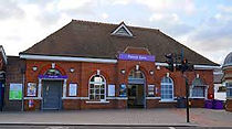
Farringdon is a London Underground and connected main line National Rail station in Clerkenwell, central London. The station is in the London Borough of Islington, just outside the boundary of the City of London. Opened on 10th January 1863 as the terminus of the Metropolitan Railway, the world's first underground passenger railway, Farringdon is one of the oldest surviving underground railway stations in the world.
Today the Underground station is served by the Circle, Hammersmith & City, and Metropolitan lines between King's Cross St Pancras and Barbican. The National Rail station is on the Thameslink route between St Pancras and City Thameslink, and on 24th May 2022 it became an interchange station between Thameslink and the Elizabeth line.
The station was initially named Farringdon Street, and was a short distance from the present station building. The line ran from the Farringdon area to Paddington, a distance of 4 mi (6 km). Parts of the building are now classed as listed.
The station was relocated on 23 December 1865 when the Metropolitan Railway opened an extension to Moorgate. It was renamed Farringdon & High Holborn on 26 January 1922 when the new building by the architect Charles Walter Clark.
The National Rail information for this station can be found here.
The platforms are covered by a high glass roof and are just below street level, except the Elizabeth line platforms, which are about 20 metres underground, see this video for more information. With the Elizabeth line being step free, there are inclined lifts here.

10th May 2000
None, this stop only serves a residential area
Step free access from street to tram
2
No

Fieldway tram stop is a light rail stop serving the Fieldway residential area of New Addington, in the London Borough of Croydon in the southern suburbs of London. It is adjacent to a northbound bus stop on the A2022 Lodge Lane.
The tram stop is served by Tramlink, which connects New Addington with central Croydon.
It is a request stop in both directions. Platforms are open air.

22th August 1867 by the Edgware, Highgate and London Railway
Step free access from street to train
Car Park
3
Toilets accessible inside ticket gate line
(Male & Female & Disabled)

No
Finchley Central is a London Underground station in the Church End area of Finchley, north London. The station is located on the High Barnet branch of the Northern line, between West Finchley and East Finchley stations; it is the junction for the short branch to Mill Hill East. The station is around 7 miles north-northwest of Charing Cross and is in Travelcard Zone 4.
The station was opened on 22nd of August, 1867 as part of the Great Northern Railway's line between Finsbury Park and Edgware stations. As part of London Underground's Northern Heights plan, Northern line trains started serving the station in 1940 and main line passenger services ended in 1941. It has also been known as: Finchley & Hendon: 1867–72, Finchley: 1872–96, Finchley (Church End): 1896–1940. The platforms are open air. There is a copy of the original Harry Beck Tube map on display here as he lived nearby and used the station frequently.
No step free access
Newsagent
30th June 1879 by the Metropolitan Railway
Toilets accessible inside ticket gate line
(Male & Female & Disabled & Baby changing)
1979 - Jubilee line, see notes below

No
Finchley Road is a London Underground station at the corner of Finchley Road and Canfield Gardens in the London Borough of Camden, north London. It is on the Jubilee line, between West Hampstead and Swiss Cottage and on the Metropolitan line between Baker Street and Wembley Park. It is in Travelcard Zone 2.
The station was opened on 30 June 1879 by the Metropolitan Railway (MR, now the Metropolitan line) on its extension from its now closed station at Swiss Cottage (a different station from the current Swiss Cottage Jubilee line station). The station was rebuilt in 1914 with entrances incorporated into a new parade of shops. On 20th November 1939 the Bakerloo line ran services through here. This service was transferred to the Jubilee line 1st May 1979. The platforms are open air, but are partially covered with a canopy.

None, but there is a parade of shops nearby
c.1860
No step
free access
2
No

Finchley Road & Frognal railway station is on Finchley Road in the London Borough of Camden in north London. It is on the North London Line, and the station and all trains serving it are operated by London Overground. It is in Travelcard Zone 2. The station is about five minutes' walk from Finchley Road Underground station, and is marked as an official out-of-system interchange. Platforms are open air. The National Rail information for this station can be found here.

15th December 1906 Opened as terminus (GNP&BR)
Bicycle Rack
Step free access from street to platform
Newsagent
4 - Underground
8 - Mainline
1st July 1861 - Mainline


1st September 1968 - Victoria line
No
Balloon mosaics in the tiles on the walls on the platforms
Finsbury Park is an intermodal interchange station in north London. It serves a number of National Rail, London Underground and bus services. The station is the third busiest Underground station outside Zone 1, with over 33 million passengers using the station in 2019.
The station is served by the Piccadilly and Victoria lines. Although thought of as a 'deep-level' tube station, Finsbury Park has no escalators as its lines are less than 8 m below street level. Both lines are at the same level, so you can actually transfer from one line to the other, going in the same direction without having to use any stairs.
Access to the Piccadilly and Victoria line platforms was previously by staircase only, reached via two narrow passages that prevented the installation of ticket barriers. As part of the upgrade of the station in the 2010s, ticket barriers were installed at both the eastern and western entrances to the station, as well as the provision of step free access throughout the station.
The Northern City Line also uses this station, which used to be part of the Underground, see here for more details. The platforms are about 7.3 metres underground. There is a crossover still in place here where it could be possible to transfer from the Piccadilly line to the Victoria line, subject to the correct signalling equipment.
The National Rail information for this station can be found here.
1840 by the Eastern Counties Railway, closed 1843
re-opened on 31st May 1846
Bicycle Rack
Step free access from street to platform
4
Newsagent
Toilet accessible outside ticket gate line
(Disabled only)
No
Forest Gate railway station is on the Great Eastern Main Line serving the district of Forest Gate in the London Borough of Newham, east London. It is 5 miles 21 chains (8.5 km) down the line from London Liverpool Street and is situated between Maryland and Manor Park. Its National Rail three-letter station code is FOG and it is in fare zone 3.
The station was opened in 1840 by the Eastern Counties Railway. Management of the station transferred from TfL Rail to the Elizabeth line on 24th May 2022.

Bicycle Rack
Kiosk
Car Park
Newsagent
Step free access from street to platform
5th June 1839 by the London & Croydon Railway (L&CR)
2
No

Forest Hill railway station serves Forest Hill in the London Borough of Lewisham, south London. The station adjoins a road which serves as part of the A205 South Circular Road.
The station is managed by London Overground, with Overground and Southern trains serving the station. Thameslink services also pass through the station. It is 5 miles 50 chains (5.63 miles, 9.05 km) down the line from London Bridge, between Honor Oak Park and Sydenham, in Travelcard Zone 3. There are four tracks through the station, although only the slow lines (the two outer tracks) have platforms.
The station was opened by the original London & Croydon Railway (L&CR) on 5 June 1839, as Dartmouth Arms (the name of the local inn).
The original station buildings were badly damaged by bombing during World War II but were patched up and survived until British Rail demolished them in 1972 and built a much smaller one, the section of railway between New Cross and Croydon follows the path of the old Croydon Canal.
The line was also used by the London and Brighton Railway from 1841 and the South Eastern Railway (SER) The platforms are open air.
The National Rail information for this station can be found here
1st March 1880 by the District Railway
Bicycle Rack
Entrance to station is within a shopping centre
2
Step free access from street to train
Although there are no toilets in the station there are some toilets that are inside the shopping centre, just outside the station entrance

No
Fulham Broadway is a London Underground station on the Wimbledon branch of the District line. It is between West Brompton and Parsons Green stations and is in Travelcard Zone 2. The station is located on Fulham Broadway (A304). It is the nearest station to Stamford Bridge stadium, the home of Chelsea Football Club. The station is in a cutting that was originally open air until it was covered by the 'Fulham Broadway Shopping Centre' development and are now about 4 metres below street level. The line then resurfaces shortly before West Brompton station.
The station was opened as Walham Green on 1 March 1880 when the District Railway (DR, now the District line) extended its line south from West Brompton to Putney Bridge.
The original station building was replaced in 1905 with a new entrance designed by Harry W Ford to accommodate crowds for the newly built Stamford Bridge stadium. It is now a Grade II listed building.

Bicycle Rack
Step free access from street to train
28th March 1994
2
No

Gallions Reach DLR station is a station on the Docklands Light Railway (DLR) in the Royal Docks area of east London. It serves the University of East London (UEL) Docklands Campus as well as recent residential developments around Royal Albert Dock. The station is located on the DLR's Beckton branch, between Cyprus and Beckton stations and the platforms are elevated above the road. It is in Travelcard Zone 3.
The crossover junction north of the station, which is normally used for trains from the west going to Beckton DLR depot, can also be used for trains from Beckton and Poplar to reverse. This is the easternmost station on the DLR, although Beckton is actually further west.
Similar to other stations on the Beckton branch, the platforms have not been extended to accommodate 3-car trains, with selective door operation being used instead.
14th December 1947
2
No
Newsagent
No step
free access

Parade of shops just outside
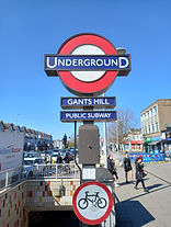
Gants Hill is a London Underground station in the largely residential Gants Hill district of Ilford in East London. It is served by the Central line and is between Redbridge and Newbury Park stations on the Hainault loop. It is in Travelcard Zone 4. It is the easternmost station to be below ground on the London Underground network and the busiest on the Hainault loop.
Between 1942–1945 the tunnels had been constructed, but the station had not yet opened, so the tunnels were used by Plessey electronics as a munitions factory during the war.
The station ticket hall is located directly beneath Gants Hill roundabout and is reached via pedestrian subways. It opened on 14 December 1947 as an extension of the Central line to form the new part of the Hainault loop. The station is known for its distinctive architecture featuring barrel-vaulted halls at platform level designed by Charles Holden,
but does not have any external building. The platforms are about 12.8 metres below ground.
More photos can be seen at: https://tubemapper.com/gants-hill-station/

None, but this is in the centre of Croydon shopping area
11th May 2000
1 - single direction
Step free access
from street to tram

No
George Street tram stop is a tram stop in Croydon, south London, served by Tramlink. It is one of the busiest stops on the line as it is the most centrally located stop for the main shopping areas. It is almost directly outside the former Allders store and is on the site of the Park Place proposed development. At this stop, trams only depart in a westbound direction.
1st December 1910 by the Great Eastern Railway
Car Park
24th May 2022 - Elizabeth line
4 (2 islands)
Step free access from street to platform
Bicycle rack
Toilets accessible inside ticket gate line
(Male & Female & Disabled)

No
Gidea Park railway station is on the Great Eastern Main Line, serving the neighbourhood of Gidea Park in the London Borough of Havering, east London. It is 13 miles 41 chains (21.7 km) down the line from London Liverpool Street and is situated between Romford and Harold Wood. Its three-letter station code is GDP. The National Rail information for this station can be found here, and it is in Travelcard zone 6.
The station, constructed in a cutting, was opened as Squirrels Heath & Gidea Park on 1 December 1910 by the Great Eastern Railway on that company's main line out of London Liverpool Street. In 1913, it was renamed Renamed Gidea Park & Squirrels Heath. On 20th February 1969 it was renamed Renamed Gidea Park. On the 24th May 2022, it was transferred from TfL Rail to the Elizabeth line. Platforms are open air.
Snack Bar
1 Oct 1868 by the Metropolitan Railway (District)
5 (plus 1 disused)
No step
free access
1906 by the Great Northern, Piccadilly and Brompton Railway


No
District line platform
Piccadilly line platform
Gloucester Road is a London Underground station in Kensington, west London. The station entrance is located close to the junction of Gloucester Road and Cromwell Road. Close by are the Cromwell Hospital and Baden-Powell House.
The station is served by the District, Circle and Piccadilly lines. On the District and Piccadilly lines, the station is between South Kensington and Earl's Court, and on the Circle line, it is between South Kensington and High Street Kensington. It is in London fare zone 1.
The station has two buildings: sub-surface platforms, opened in 1868 by the Metropolitan Railway as part of the company's extension of the Inner Circle route from Paddington to South Kensington and to Westminster; and deep-level platforms opened in 1906 by the Great Northern, Piccadilly and Brompton Railway. A variety of underground and main line services have operated over the sub-surface tracks. The deep-level platforms have remained largely unaltered with no lift access. A disused sub-surface platform features periodic art installations as part of Transport for London's Art on the Underground scheme. These are both listed buildings and are connected underground. There used to be 4 lifts here, now there are only 2 and the empty shafts remain for ventilation. The station has also been known as Brompton (Gloucester Road): 1868–1907. The platforms are about 7 metres underground (District/Circle) and about 20 metres underground (Piccadilly).
Bicycle Rack
22nd June 1907 by the Charing Cross, Euston & Hampstead Railway
5 (1 side, 2 island)
Step free access from street to platform since 2008
Toilets accessible outside ticket gate line
(Male & Female & Disabled & Baby changing)

No
Golders Green is a London Underground station in Golders Green, north London. The station is on the Edgware branch of the Northern line between Hampstead and Brent Cross. It is in Travelcard Zone 3 and is the first surface station on the Edgware branch when heading north.
Golders Green station was opened by the Charing Cross, Euston & Hampstead Railway (CCE&HR, now part of the Northern line) on 22 June 1907. Platform 1 is no longer in public use, although the tracks are still in situ and can be used if needed and there is a sliding door at the end, giving access to the depot . Platforms are open air and covered with a canopy. To the south of the station in the tunnels beneath Hampstead Heath is the partially built but uncompleted North End or Bull & Bush station.
1st April 1914
2
Florist
No step
free access
No

Goldhawk Road is a London Underground station located in the London Borough of Hammersmith and Fulham, on the south side of Goldhawk Road, about 250 metres (820 ft) west of Shepherd's Bush Green. It is served by the Circle and Hammersmith & City lines in Travelcard Zone 2.
Although the line here was opened on 13 June 1864, a station was not opened at this location until 1 April 1914 when Shepherd's Bush station (now Shepherd's Bush Market) was moved from its original location between Uxbridge Road and Goldhawk Road to a location on the north side of Uxbridge Road. Platforms are open air.
Heel bar/
Key cutter
22nd June 1907
No step
free access
2

No
Goodge Street is a London Underground station on Tottenham Court Road in Fitzrovia, West End, London. It is on the Northern line's Charing Cross branch between Tottenham Court Road and Warren Street stations, and is in Travelcard Zone 1. To confuse matters, this station was named Tottenham Court Road: between 1907–08 and was opened on 22 June 1907 the Charing Cross, Euston and Hampstead Railway, but changed to the present name on 9 March 1908 before an interchange was built between the previously separate (and differently named) Northern line and Central line stations at the present Tottenham Court Road station. From late 1943 until the end of the Second World War the Goodge Street shelter was used by the Supreme Headquarters Allied Expeditionary Force. The platforms are about 28.5 metres underground
1901 by the Great Eastern Railway
Bicycle Rack
Step free access from street to platform
4
No
Coffee Kiosk

Goodmayes railway station is on the Great Eastern Main Line serving the district of Goodmayes in the London Borough of Redbridge, east London. It is 9 miles 23 chains (14.9 km) down the line from London Liverpool Street and is situated between Seven Kings and Chadwell Heath. Its three-letter station code is GMY, The National Rail information for this station can be found here and it is in Travelcard Zone 4.
The station was opened in 1901 by the Great Eastern Railway. The station once had an extensive shunting yard for goods traffic, but this fell into disuse following the Beeching cuts to the railway system in 1963, and was eventually dismantled. The station was transferred from TfL Rail to the Elizabeth line 24th May 2022. The platforms are open air.
1860 by the Hampstead Junction Railway
Bicycle Rack
3
Step free access from street to platform
Coffee Kiosk
Toilets accessible inside ticket gate line
(Male & Female & Disabled & Baby changing)

Yes for some services
Gospel Oak railway station is in the London Borough of Camden in north-west London. It is on the North London Line (NLL) and is also the western passenger terminus of the Gospel Oak to Barking Line - known informally as GOBLIN. Passengers using Oyster cards are required to tap on interchange Oyster card readers when changing between the two lines. The station is in Travelcard Zone 2, and is managed by London Overground which runs all passenger trains at the station. The National Rail information for this station can be found here.
The station opened in 1860 as Kentish Town on the Hampstead Junction Railway from Camden Road to Old Oak Common Junction south of Willesden Junction. It was renamed Gospel Oak in 1867. The platforms are open air. The station was previously known as Kentish Town, not to be confused with the underground one of the same name. The platforms are high above street level with stairs and two lifts. The North London Line (NLL) has two platforms and the Barking line has a short terminal platform North of which are two separate through freight tracks which join the NLL just west of the station.
Estate Agent
1st May 1903 by the Great Eastern Railway
2
No step
free access
Toilets accessible inside ticket gate line
(Male & Female)

No
Grange Hill is a London Underground station on the Central line which lies in the parish of Chigwell in the Epping Forest district of Essex. The boundary with the London Borough of Redbridge is immediately to the east of the station buildings. The station is between Hainault and Chigwell stations. The station has been in Travelcard Zone 4 since 2 January 2007.
The station was opened by the Great Eastern Railway on 1 May 1903 on their Fairlop Loop line between Woodford and Ilford. The station ticket office was reconstructed in July 1944 following destruction of the original building by a German V1 'Doodlebug'. It was closed again 29 November 1947 for electrification work and reopened 21 November 1948. The platforms are open air.
None - serves residential area and Addington Palace Golf club
11th May 2000
2
No
Step free access from street to tram

Gravel Hill tram stop is a light rail stop serving Addington, in the London Borough of Croydon in the southern suburbs of London. It is the main destination for tourists visiting the historic site of Addington Palace. It is also used by students who attend John Ruskin College and is the nearest stop for Forestdale.
The tram stop is served by Tramlink, which connects New Addington with central Croydon.
10th January 1863 by the Metropolitan Railway
Bicycle Rack
2
No step
free access
Coffee Shop
Newsagent

No
Great Portland Street is a London Underground station near Regent's Park. It is between Baker Street and Euston Square on the Hammersmith & City, Circle and Metropolitan lines. Great Portland Street station is listed as a building of National Significance and lies in Travelcard Zone 1.
The station was part of the world's first underground railway, the Metropolitan Railway, which opened between "Bishop's Road" (now Paddington) on the Hammersmith & City line and "Farringdon Street" (close to the present-day Farringdon station). It was opened on 10 January 1863 as "Portland Road", changed to its present name on 1 March 1917 but was renamed "Great Portland Street and Regents Park" in 1923 and then reverted to its present name in 1933. This is a listed building.
The platforms are about 7 metres underground. All three lines share the same pair of tracks from Baker Street Junction to Aldgate Junction making this section of track one of the most intensely used on the London Underground network.
Newsagent
15th December 1906 (GNP&BR)
6 (2 for each line)
Step free access
from street to train
Dry Cleaners
Toilets accessible outside ticket gate line
(Male & Female)
7th March 1969
1st May 1979

No
Green Park is a London Underground station located on the edge of Green Park, with entrances on both sides of Piccadilly. It is served by the Jubilee, Piccadilly and Victoria lines. On the Jubilee line it is between Bond Street and Westminster; on the Piccadilly line it is between Piccadilly Circus and Hyde Park Corner and on the Victoria line it is between Victoria and Oxford Circus. It is in fare zone 1.
The station was opened in 1906 by the Great Northern, Piccadilly and Brompton Railway (GNP&BR) and was originally named Dover Street due to its location in that street. The original building was demolished and the site was redeveloped and is now 5-7 Dover Street. The entrance was relocated and the station renamed in the 1930s when lifts (shafts still in situ) were replaced with escalators and it was also extended in the 1960s and 1970s when the Victoria and Jubilee lines were constructed.
There is in an entrance in Devonshire House which is now a listed building.
When the Victoria line was added, additional ventilation tunnels were installed.
It can take about three minutes to change between lines as some of the pedestrian tunnels are quite long.
Platform depths are about:
23.4 metres - Victoria line, 27.4 metres - Piccadilly line, 31.1 metres - Jubilee line.
The station is near The Ritz Hotel, the Royal Academy of Arts, St James's Palace, Berkeley Square, Bond Street, the Burlington Arcade and Fortnum & Mason, and is one of two serving Buckingham Palace.
Car Park
Bicycle Rack
Re-sited 30 June 1947
Yes for Mainline only
Cafe Bar
Newsagent
Unisex toilet on the platform accessible
with a Radar key
Step free access from street to platform via
an inclinator.
2 for Central line
1 for Mainline
1 October 1904
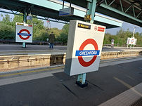
Greenford is a London Underground and National Rail station in Greenford, Greater London, and is owned and managed by London Underground. It is the terminus of the National Rail Greenford Branch Line, 2 miles 40 chains (4.0 km) down the line from West Ealing and 9 miles 6 chains (14.6 km) measured from London Paddington. On the Central line, it is between Perivale and Northolt stations while on National Rail, the next station to the south on the branch is South Greenford.
The original Greenford station was opened by the Great Western Railway on 1 October 1904 on the joint "New North Main Line" (present-day Acton–Northolt line). Remnants of the original platforms can be seen from the train.
The present station, adjacent to the original, was designed by Brian Lewis and built in the Central line extension of the 1935-40 New Works Programme of the London Passenger Transport Board.
The National Rail information for this station can be found here. With this station you go up to the open air platforms, rather than down. The station was originally built with an escalator and no lift, but the escalator has now been replaced with an inclinator (Inclined lift). The mainline GWR platform is a "Spanish Solution" platform, however the doors normally open on one side - check display boards for information.
Bicycle Rack
11 January 1878
(see notes below)
4 (2 for DLR &
2 for Mainline)
20 November 1999 (DLR)
Step free access
from street to train

No
Car Park
Toilets in the booking hall are only available during staffing hours
Greenwich station is about 400 m south-west of the district centre, in London, England. It is an interchange between National Rail between central London and Dartford (north Kent), and the Docklands Light Railway (DLR) between Lewisham to the south and Docklands and the City of London. It is in Travelcard Zones 2 and 3. It was opened 24 December 1838 by the London and Greenwich Railway which is reputed to be the world's first suburban railway. It was re-sited 12 April 1840 and again on 11 January 1878, where the current building remains.
It is the nearest National Rail station to the centre of Greenwich, but Cutty Sark for Maritime Greenwich DLR station is closer to the town centre and its tourist attractions.
The National Rail information for this station can be found here. The platforms are all open air, however the DLR enters a portal at the end of the northbound platform going to Cutty Sark
28 June 2012
Bicycle Rack
Step free access from street to cable car
1
There are toilets and a cafe in the visitor centre attached to the ticket office
Yes
Car Park

The London Cable Car nicknamed the Dangleway, is a cable car link across the River Thames in London, England, built by Doppelmayr with sponsorship from the airline Emirates. The service opened on 28 June 2012 and is operated by Transport for London (TfL).[ In addition to transport across the river, the service advertises "a unique view of London". The duration of a single crossing is ten minutes (reduced to five minutes in rush hour as the service speed is increased).
The service comprises a 0.62-mile (1.00 km) gondola line that crosses the Thames from the Greenwich Peninsula to the Royal Victoria Dock, to the west of ExCeL London. The cable car is based on monocable detachable gondola (MDG) technology, a system which uses a single cable for both propulsion and support. This stop is a short walk away from the 02 arena
The Emirates sponsorship expired on 28 June 2022. From October 2022, it will be sponsored by the Swedish firm IFS and it will be known as the IFS Cloud Cable Car.

1 January 1869 by the London and South Western Railway
None, but there are some shops within a short walk.
2 - 1 island shared with both services
No step
free access
Metropolitan services began in 1877
No

Gunnersbury is a London Overground and London Underground station in Gunnersbury in London, England on the North London line. The station opened on 1 January 1869 and is served by District line trains to and from Richmond, and by Arriva Rail London on the London Overground network. On the District line the station is between Turnham Green and Kew Gardens, and on the North London line it is between South Acton and Kew Gardens.
The station was opened as Brentford Road on 1 January 1869 by the London and South Western Railway (L&SWR) on a new branch line to Richmond built from the West London Joint Railway starting north of Addison Road station (now Kensington (Olympia))
The National Rail information for this station can be found here. This station does not have an external building and although the platforms are open air, the tracks are in a cutting, so there are bridges at either end of the platforms. The tracks here are shared by the Overground and Underground. The station used to have 5 platforms and if you look at Google maps, you can see there is now a car park where the former platforms were.