
Background picture taken at Dollis Hill
Toilet

Dagenham East is a London Underground station located on the eastern side of the town of Dagenham in the London Borough of Barking and Dagenham, east London. It is on the District line between Dagenham Heathway to the west and Elm Park to the east. It is 6.4 kilometres (4.0 mi) along the line from the eastern terminus at Upminster and 27.8 kilometres (17.3 mi) to Earl's Court in central London where the line divides into numerous branches. The station has moderate usage for a suburban station, with approximately 3 million exits/entrances per year.
It was opened as a main line station in 1885 and was called Dagenham. The current station buildings date from the introduction of electric services in 1932 and of typical railway architectural style for the period, with little trace remaining of the station's Victorian origins. There are disused platforms here where the mainline (c2c) used to stop, but do not stop any more. The platforms are open air.

Dagenham Heathway is a London Underground station serving the town of Dagenham in the London Borough of Barking and Dagenham, east London. It is on the District line between Becontree and Dagenham East. It is 7.7 kilometres (4.8 mi) along the line from the eastern terminus at Upminster and 26.5 kilometres (16.5 mi) to Earl's Court in central London where the line divides into numerous branches.
The station was opened on 12 September 1932. The station was constructed and initially operated by the London, Midland and Scottish Railway with services provided by the District line from the outset. The station was called Heathway when it first opened, changing to its present name in 1949. Platforms are open air.

Dalston Junction is an inter-modal rail and bus transport interchange in Dalston, London. It is located at the crossroads of Dalston Lane, Kingsland Road and Balls Pond Road. The station served by London Overground East London line and is in Zone 2. The station is located in a short section of cut and cover tunnel north of the Kingsland Viaduct. It was opened in 1865, but then closed 30th June 1986. It then reopened 27th April 2010 as a temporary terminus for the East London Line, then the line was extended through and opened fully on 28th February 2011. Platforms are underground, when the original station was built, the platforms were open air, but as the area has ben redeveloped, it was rebuilt using the "cut and cover" method. More information can seen here. The National Rail information for this station can be found here.

Dalston Kingsland railway station is a railway station on the North London Line in London, England. It is in the Dalston area of the London Borough of Hackney, on the western side of Kingsland High Street and opposite Ridley Road Market. The station and all trains serving it are operated by London Overground. It is in Travelcard Zone 2. Kingsland railway station was first opened on the site in 1850, but was replaced by Dalston Junction in 1865. The current station was opened by British Rail in 1983.
A station was first opened on the site on 9 November 1850 by the North London Railway. It closed on 1 November 1865 when an extension was built to Broad Street in the City of London and a triangular junction was installed which joined the existing tracks to the east and west of the station. Platforms are open air. The National Rail information for this station can be found here.

Dartford railway station serves the town of Dartford in Kent, England. It is 17 miles 12 chains (27.6 km) down the line from London Charing Cross. Train services from the station are operated by Southeastern and Thameslink. Southeastern also manages the station. Dartford is a major interchange station in the North Kent region of the Southeastern network. Platforms are open air. In September 2015 Transport for London extended the London fare zones to add Dartford to zone 8, thus allowing Oyster and Contactless payment methods to be used. The National Rail information for this station can be found here.

Debden is a London Underground station on the Central line in the east of Loughton, in the Epping Forest district of Essex. The station is between Loughton and Theydon Bois. It is located in Station Approach off Chigwell Lane (A1168) and is in Travelcard
The station was originally opened on 24 April 1865 by the Great Eastern Railway as part of an extension of the railway's Loughton branch to Epping and Ongar. Initially called Chigwell Road, it was soon renamed on 1 December 1865 as Chigwell Lane. Platforms are open air.
Other names known as Chigwell Road: 1865, Chigwell Lane: 1865–1949. This also operates as an intermediate terminus for eastbound trains from central London, & a number of peak-hours trains terminate rather than continuing to Epping
More photos can be seen at: https://tubemapper.com/debden-station/
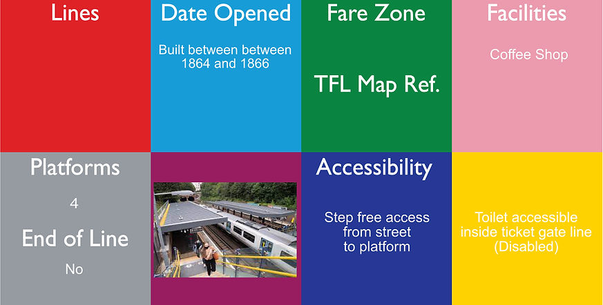
Denmark Hill railway station is in the area of Denmark Hill in south London, England, on the South London and Catford Loop lines. It is 4 miles 22 chains (6.9 km) down the line from London Victoria. It is managed by Thameslink.
The station was built between 1864 and 1866. Its design by Charles Henry Driver is in the Italianate style, with an extremely decorative frontage and French pavilion roofs. In the period 2011–2013 the station underwent a redesign with the construction of a new ticket office with access from Champion Park, new walkways and lifts to the platforms. Platforms are open air. The National Rail information for this station can be found here.

Deptford is a National Rail station in Deptford in London, England. It is on the North Kent Line, 3 miles 7 chains (5.0 km) down the line from London Bridge, and has staggered platforms on the London Bridge – Greenwich Railway Viaduct, a high brick viaduct on which the line runs at this point above Deptford High Street.
It is in Travelcard zone 2.
Opened in 1836, Deptford station is the oldest railway station in London that is still in use. It came into existence when the London and Greenwich Railway opened its first section between Spa Road, Bermondsey, Platforms are open air. The National Rail information for this station can be found here.

Deptford Bridge is a Docklands Light Railway (DLR) station in Deptford, London in England. The station is elevated above both local roads and Deptford Creek, and is adjacent to Lewisham College and Deptford market. The platforms here are open air.
Devons Road is a Docklands Light Railway (DLR) station located in between Bromley-by-Bow and Bow Common. The station takes its name from the B140 Devons Road and is between Langdon Park and Bow Church stations and is in Travelcard Zone 2. It is on the Stratford to Poplar branch of the DLR with services continuing on to Canary Wharf and Lewisham. Platforms are open air and the line runs in a cutting, so are partially covered at one end.

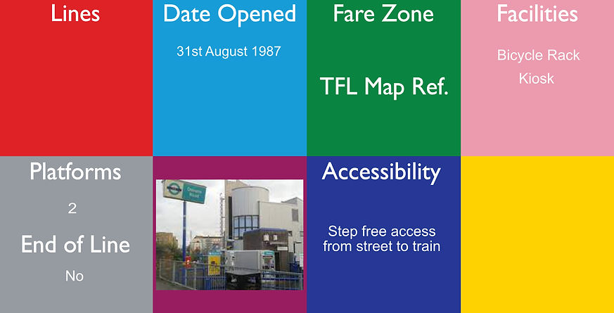
Dollis Hill is a London Underground station at Dollis Hill near to Willesden and Gladstone Park of the London Borough of Brent. It is on the Jubilee line, between Willesden Green and Neasden stations and is in Travelcard Zone 3. Metropolitan line trains pass through the station without stopping here.
The station has no surface buildings. Other names known as: Dollis Hill and Gladstone Park 1931 - 1933
The station opened on 1 October 1909 as part of the Metropolitan line. From 20 November 1939 it was on the Stanmore branch of the Bakerloo line and was transferred to the Jubilee line in 1979. It has two exits. The platforms are open air
In 1995 four sets of enamel panels designed by Amanda Duncan were installed in the subway between the north and south exits.

Dundonald Road tram stop is a stop on the Tramlink service to the south of Wimbledon town centre, in the London Borough of Merton. Access is direct from the pavement on the north side of Dundonald Road at the site of the old level crossing (where the old, now demolished, signal box used to stand on the south side).[citation needed]
At this point, the track follows the route of the old West Croydon to Wimbledon Line, although there was no station on the Dundonald Road site. The platforms are open air.