
Background photo taken at Baker Street

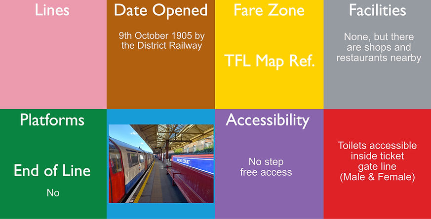
10 - 2 are a terminus
Baker Street is a London Underground station at the junction of Baker Street and the Marylebone Road in the City of Westminster. It is one of the original stations of the Metropolitan Railway (MR), the world's first underground railway, opened on 10th January 1863.
The station is in Travelcard Zone 1 and is served by five lines. On the Circle and Hammersmith & City lines it is between Great Portland Street and Edgware Road. On the Metropolitan line it is between Great Portland Street and Finchley Road. On the Bakerloo line it is between Regent's Park and Marylebone, and on the Jubilee line it is between Bond Street and St John's Wood.
This is the nearest station for the famous 221B Baker Street related to Sherlock Holmes and also Madame Tussauds
There was a lift in use until 24th November 1940, when the original Bakerloo line station closed and the existing building opened, which is now a listed building.
Approx Depth Underground: Jubilee Northbound 19.2 metres, Jubilee Southbound 22.5 metres, Bakerloo Northbound 19.2 metres, Bakerloo, southbound 22.5 metres, Metropolitan & Circle 6.2 metres.
Key dates: 10th January 1863 Opened by the Metropolitan Railway (Paddington to Farringdon), April 1868 Opened (Metropolitan Railway platforms to north to Swiss Cottage.)
10th March 1906 Opened (BS&WR - Bakerloo, as terminus to Elephant & Castle), 27th March 1907 line opened to Marylebone, 20th November 1939 line opened to Stanmore). In 1949 the circle line appeared on the map, using existing stations.
1st May 1979 The Bakerloo line to Stanmore becomes the Jubilee line and the line to Charing Cross opens
30th July 1990 The Metropolitan service to Hammersmith becomes the Hammersmith & City Line
More photos can be seen at: https://tubemapper.com/baker-street-station/

The station opened on 6 December 1926 as part of the Morden extension of the City and South London Railway south from Clapham Common. The line and other stations on the extension had opened earlier, on 13 September 1926. The station is between Clapham South and Tooting Bec stations.
The station was hit was by a bomb during the war and a bus went through the road.
Along with the other stations on the Morden extension, the building was designed by architect Charles Holden. They were Holden's first major project for the Underground. He was selected by Frank Pick, general manager of the Underground Electric Railways Company of London (UERL), to design the stations after he was dissatisfied with designs produced by the UERL's own architect, Stanley Heaps. The Underground station buildings (one either side of the main road) are listed Grade II
The estimated depth underground is 13.4 metres

(DLR + Northern
lineOnly)
29 July 1991 (DLR)
8
30 July 1900 (CLR)
8 August 1890 (W&CR)
25 February 1900
(C&SLR)
Bank and Monument are interlinked London Underground and Docklands Light Railway (DLR) stations that form a public transport complex spanning the length of King William Street in the City of London. Bank station, named after the Bank of England, opened in 1900 at Bank junction and is served by the Central, Northern and Waterloo & City lines and the DLR. Monument station, named after the Monument to the Great Fire of London, opened in 1884 and is served by the District and Circle lines. The stations have been linked as an interchange since 18th September 1933. The building is a listed building. This station has been nominated as the most confusing for its number of exits. There are 8 platforms here, however they are numbered 3 to 10 as platforms 1 and 2 are classed as Monument Station, which although is connected underground, is classed as a separate station, which can be seen on the diagram here.
In May 2022, there was extensive work completed, including the realignment of the Northern line platforms to allow greater footfall through the station. This video explains the proposals before they were completed and a little more information here. The day of closure can be seen here. The reopening can be seen here. There is also a partial Greathead shield embedded in the tunnels here, which can be found coming from the Waterloo & City platform and follow the signs for the DLR and walking along the tunnel.
Approx depth underground: Waterloo & City - 13.4 metres, Central line 20.7 Metres, Northern line 30.5 metres, DLR - 41.4 metres

2 (& 2 abandoned)
Barbican is a London Underground station situated near the Barbican Estate, on the edge of the ward of Farringdon Within, in the City of London in Central London. It has been known by various names since its opening in 1865, mostly in reference to the neighbouring ward of Aldersgate. (Aldersgate Street: 1865–1910, Aldersgate: 1910–23, Aldersgate & Barbican: 1923–68)
The station is served by the Circle, Hammersmith & City and Metropolitan lines, which all run on the same tracks. It is situated between Farringdon and Moorgate stations, in Travelcard Zone 1. Until 2009, Barbican was additionally served by Thameslink services to and from Moorgate and there are disused platforms still in situ from where this service used to run.
All three lines are served by the 2 tracks, making this one of the most intensely used. Although the station is not advertised as being step free, if you go to the west end of platform 2, there is a lift that takes you through to Farringdon where there is step free access to the Elizabeth line at Farringdon. This is a single lift and the only step free route in/out the station.
The platforms are about 8.5 metres below street level, but have open air platforms and the station used to have a high glass roof. Thameslink services used to run here, but now there are 2 disused platforms.
The Circle line services were added in 1949 and the Hammersmith & City line services were added 30th July 1990.

Yes for the Hammersmith & City Line
9 facing 8 tracks
Barking is an interchange station serving the town of Barking, east London. It is served by London Underground, London Overground and National Rail main line services. It is located on Station Parade, in the town centre.
On the Underground it is a stop on the District line and is also the eastern terminus of the Hammersmith & City line; on the National Rail network it is served by c2c services operating to and from Fenchurch Street; and on the Overground it is the eastern terminus of the Gospel Oak to Barking Line. The building is classed listed There is a platform here where the doors can open either side of the train and this is known as the "Spanish Solution"
The platforms here are open air. The National Rail information for this station can be found here.

Barking Riverside is a railway station that opened 18th July 2022 in the London Borough of Barking and Dagenham, east London, that will serve the Barking Riverside regeneration area including housing, leisure and shopping facilities. The National Rail information about this station can be found here

Barkingside is a London Underground station on the Central line. It is on the eastern edge of Barkingside (a district of Ilford) in east London at the end of a cul-de-sac off Station Road (which is itself a cul-de-sac). The station is next door to the home of Redbridge F.C. It is between Newbury Park and Fairlop stations and has been in Travelcard Zone 4 since 2 January 2007. This station is a listed building.
The platforms here are open air.
4
Barons Court is a London Underground station in West Kensington in the London Borough of Hammersmith and Fulham, Greater London. This station serves the District line and the Piccadilly line with a cross level interchange. Barons Court is between
West Kensington and Hammersmith on the District line, and between Earl's Court and Hammersmith on the Piccadilly line and is in Travelcard Zone 2. East of the station, the Piccadilly line descends into tunnel towards Earl's Court and the District line continues in a cutting to West Kensington. The station is the last open air stop for eastbound trains on the Piccadilly line until Arnos Grove and has cross-platform interchange with the District line. The station is a listed building.
The platforms here are open air, although the station entrance goes over a road bridge and the Piccadilly line goes underground from here, so the lines are in a cutting. On the platforms, there are wooden benches with the station name along the back in enamel, which is a unique feature on the Underground and the booking hall has got very distinguished green tiles.

5
Only for Overground

1 May 1867 by the London, Brighton and South Coast Railway
Bicycle Rack
No step free access
Toilets accessible inside gate line (Male & Female)
Battersea Park is a suburban railway station in the London Borough of Wandsworth, south London. It is at the junction of the South London Line and the Brighton Main Line (although the physical connection between the lines has been removed), 1 mile 23 chains (2.1 km) measured from London Victoria.
This station does not normally show on the tube map, but does show on the London Overground map as this is serviced by a Parliamentary train, which is normally only one or two services a day. See the current timetable for for service availability.
The station has an out of station interchange (OSI) with the new Battersea Power Station tube station
Platforms are open air and above ground and the lines run over a road. The National Rail information for this station can be found here.
Geoff Marshall has produced a video explaining why this is not shown on the map, which can be seen here.

Battersea Power Station is a London Underground station in Battersea, London, and forms the terminus of the Northern line extension to Battersea (NLE).
Partially funded by the redevelopment of Battersea Power Station the station serves the redevelopment site, as well as Battersea itself. The station is located on Battersea Park Road, close to Battersea Park railway station and a short walking distance from Queenstown Road (Battersea) railway station. The line and station opened on 20 September 2021. It is the only station on the London Underground network to include the word 'station' in its name, which was agreed to because the developers of the old Battersea Power Station have applied a significant amount of funding and they requested the name to have the word "station" in the name, so the external signs do not follow the pattern of having the station name followed by the word station. If it did, then it would be "Battersea Power Station station"

Bayswater is a London Underground station in the Bayswater area of the City of Westminster. The station is on the Circle and District lines, between Notting Hill Gate and Paddington stations and is in Travelcard Zone 1. It is less than 100 metres (330 ft) away from the Central line's Queensway station. and it is generally quicker to walk there from here , than what it would be to go by train.
The platforms are partially covered at, 5 metres below street level, it used to have a high glass roof and is one of the first stations ever opened.

Beckenham Hill railway station is in the London Borough of Lewisham in south London, very close to the border with Bromley. It is 9 miles 45 chains (15.4 km) measured from London Victoria.
It is in Travelcard Zone 4, and the station and all trains are operated by Thameslink. It serves the mainly residential areas of Southend Road and Downham as well as parts of Bellingham.
Platforms are open air and level with the street. The National Rail information for this station can be found here.

Yes for the trams and some mainline services
Tram - 2 (island)
Mainline - 4
Beckenham Junction is the main railway and tram station in Beckenham in the London Borough of Bromley, south London. The railway stop is on the Chatham Main Line, 8 miles 53 chains (13.9 km) down the line from London Victoria and situated between Kent House and Shortlands. The tram stop is one of the eastern termini of Tramlink. The main station was opened 1st January 1857 by the Mid-Kent Railway (MKR) as a terminus, the line was extended and opened 3rd May 1858 and tram services commenced from here 23rd May 2000 and the stop is outside the station, across the car park, beside the A2015 road, which avoids Beckenham town centre.
The train station is a separate building and for train journeys, Beckenham Junction is in Travelcard Zone 4. Most trains that call are operated by Southeastern, but some Southern services also call. Platforms are open air and at street level. The National Rail information for this station can be found here.
Step free access: Mainline - Category B1. This station has a degree of step-free access to the platform, which may be in both directions or in one direction only - please check details - Step Free access to platforms 1&2 via booking hall for services to London and Crystal Palace. Step free access to platforms 3&4 via Waitrose car park and ramped side gate located on platform 4 for services away from London. Step free route between platforms in excess of 400 metres. Tram - Step free access from street to tram.

1 (Bi-directional)
Beckenham Road tram stop is a light rail stop in the London Borough of Bromley in the southern suburbs of London. The stop is located on an embankment above Beckenham Road (A234) which connects Beckenham with Crystal Palace and Penge on the site of the short-lived (1858–1860) West End of London & Crystal Palace Railway Penge station.
The tram stop is served by Tramlink, which connects central Croydon with Beckenham.
Platforms are open air and at street level.

2 - (island)
Beckton is the eastern terminus of the Beckton branch of the Docklands Light Railway (DLR) in the Docklands area of east London. It is in Travelcard Zone 2/3. The main maintenance depot for the DLR is located here. Platforms are open air and at street level.

Beckton Park DLR station is a station on the Docklands Light Railway (DLR) in the Docklands area of east London. The station is located by the north quay of the Royal Albert Dock. The station is opposite Beckton District South Park, which is open space leading to housing in South Beckton.
The station is located on the DLR's Beckton branch, between Royal Albert and Cyprus stations. It is in Travelcard Zone 3 and is the most lightly used station on the DLR. A previous railway station called Central was located largely on the same site from 1880 to 1940, on the former line from Custom House to Gallions. Platforms are open air, in a cutting under a main road.

4
(2 are now disused)
Becontree is a London Underground station located to the south of Becontree in the London Borough of Barking and Dagenham, east London. It is on the District line between Upney to the west and Dagenham Heathway to the east. It is 9.1 kilometres (5.7 mi) along the line from the eastern terminus at Upminster and 25.1 kilometres (15.6 mi) to Earl's Court in central London where the line divides into numerous branches. It is in Travelcard Zone 5.
The station was originally opened as Gale Street Halt in 1926 by the London, Midland and Scottish Railway on the existing route from Fenchurch Street in London toward Southend. Platforms are open air.

Beddington Lane tram stop is a stop on the Tramlink tramway. There was previously a railway station on this site, on the single track line from Wimbledon to West Croydon, which closed in 1997 in order for it to be converted for Tramlink use. The stop is accessible from the east from Beddington Lane, and also from the pathway leading to the west and south. In late 2014, the track immediately to the west of the tram stop was doubled, though further west the bridge carrying trams over the main line at Mitcham Junction is still single-track.
Platforms are open air at street level.

Belgrave Walk tram stop is a stop on the Tramlink service near Mitcham in the London Borough of Merton. The stop is named after Belgrave Walk, an adjacent residential street to the north.
The tram stop consists of an island platform which is accessed by pedestrian level crossings at both ends of the platform. The crossing at the western end only serves the north side of the line, whilst the one at the eastern end forms a path connecting neighbourhoods on either side of the line. Platforms are open air at street level.

Image from https://www.accessable.co.uk/venues/bellingham-station#d02217fc-c319-414d-8bee-54de632bfccd
Bellingham railway station is in the London Borough of Lewisham in south London. It is in Travelcard Zone 3, and the station and all trains are operated by Thameslink. The station buildings lie on Randlesdown Road in Bellingham; the platforms are below street level.
The station, which lies on what today is known as the Catford Loop, was opened on 1 July 1892. It is 8 miles 73 chains (14.3 km) measured from London Victoria. The platforms are open air in a cutting with the main building at road level above the platforms. The National Rail information. for this station can be found here

Belsize Park is a London Underground station in Belsize Park, north-west London. It is on the Edgware branch of the Northern line, between Chalk Farm and Hampstead stations, and is in fare zone 2. It stands at the northern end of Haverstock Hill. In July 2011 it became a Grade II listed building.
Platforms are about 32 metres underground and there is an underground bunker here that was used during the war. There are 3 lifts here, but there are still steps used to get from the street to the platform. There is a notice at the bottom of the emergency staircase that says there are 219 steps, however there are only 189.

Bermondsey is a London Underground station. It is in the eastern part of Bermondsey in the London Borough of Southwark and also serves the western part of Rotherhithe, in south-east London.
The station itself was designed by Ian Ritchie Architects. Although it was originally intended to have a multi-storey office building on the top, London Underground have yet to realise the second phase of the scheme.
It is on the Jubilee line, having been built as part of the Jubilee Line Extension between London Bridge and Canada Water stations. It is notable for its extensive use of natural light. The main station entrance is on the south side of Jamaica Road.
The station is in Travelcard Zone 2.
Platforms are about 15 metres underground.

Bethnal Green is a London Underground station in Bethnal Green, London, served by the Central line. There is no external building for this station. It lies between Liverpool Street and Mile End stations, is in Travelcard Zone 2, and is open 24 hours on a Friday and Saturday as part of the Night Tube service. The station was opened as part of the long planned Central line eastern extension on 4 December 1946, having previously been used as an air-raid shelter. On 3 March 1943, 173 people, including 62 children, were killed in a crush while attempting to enter the shelter, in what is believed to be the largest loss of civilian life at one time in the UK during the Second World War.
The Overground station is about half a mile away (10 minute walk) from this station.
The platforms are somewhere between 7 metres (Mile End) and 15.8 metres (Liverpool Street) deep.

Bethnal Green is a London Overground station on the Lea Valley lines in the southern part of Bethnal Green, in East London. The station is 1 mile 10 chains (1.8 kilometres) down the line from London Liverpool Street; the next station is either Hackney Downs (on the Chingford branch) or Cambridge Heath (on the route to Cheshunt and Enfield Town). It is an interchange station between three services operated by London Overground. Its three-letter station code is BET and it is in Travelcard zone 2.
The station was opened in 1872 and was formerly called Bethnal Green Junction until 1946.
The Underground station is about half a mile (10 minute walk) away from this station.
The platforms are open air and above street level as the lines go over the main road next to the station. The National Rail information for this station can be found here.

2 islands giving 4 in total
Bickley railway station is on the Chatham Main Line in England, serving the town of Bickley in the London Borough of Bromley, south-east London. It is 11 miles 76 chains (19.2 km) down the line from London Victoria and is situated between Bromley South and St Mary Cray on the main line. Southeastern trains branch from the main line south of Bickley and run to Orpington via Petts Wood. Thameslink services run either via Petts Wood or St Mary Cray on the main line. The platforms are open air and in a cutting with the station entrance above at road level. The National Rail information for this station can be found here.

1 for the trams
1 for the trains
Birkbeck is a railway station and light rail stop in the London Borough of Bromley in the southern suburbs of London. On the rail network it is 10 miles 26 chains (16.6 km) measured from London Victoria. It is located on Elmers End Road (A214) and alongside Beckenham Crematorium. When the train station opened in 1930, it used to have 2 platforms, however it only has one now and since 30th May 2000, the second platform has been for the trams, so although there are 2 open air platforms, one is for the tram and the other is for the trains and both lines are single line working.
The National Rail information for this station can be found here.
There is step free access from the street to the tram, but there is no step free access to the trains at all.
2 for Underground
6 for Mainline
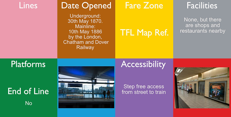
Blackfriars, also known as London Blackfriars, is a central London railway station and connected London Underground station in the City of London. It provides Thameslink services: local (from North to South London), and regional (Bedford and Cambridge to Brighton) and limited Southeastern commuter services to South East London and Kent. Its platforms span the River Thames, the only one in London to do so, along the length of Blackfriars Railway Bridge, a short distance downstream from Blackfriars Bridge. There are two station entrances either side of the Thames, along with a connection to the London Underground District and Circle lines.
The main line station was opened by the London, Chatham and Dover Railway with the name St. Paul's in 1886, as a replacement for the earlier Blackfriars Bridge station (now the present station's southern entrance) and the earlier Blackfriars railway bridge. This increased capacity of rail traffic through the Snow Hill Tunnel to the rest of the rail network. The Underground station opened in 1870 with the arrival of the Metropolitan District Railway. The station was renamed Blackfriars in 1937 to avoid confusion with St Paul's tube station. It was rebuilt in the 1970s, which included the addition of office space above the station and the closure of the original railway bridge, which was demolished in 1985, but remnants can still be seen from the river Thames.
In 2009, the station underwent major refurbishments to improve capacity, which included the extension of the platforms across the railway bridge and a new station entrance on the South Bank. The underground station was rebuilt at the same time, and work was completed in 2012.
The underground platforms are sub surface and are between 3.5 metres (Temple) and 7.3 metres (Mansion House) dep and the Mainline platforms are on a bridge which spans the the width of the Thames. The National Rail information for this station can be found here.

Blackhorse Lane tram stop is a light rail stop in the London Borough of Croydon in the southern suburbs of London.
The tram stop is located on a section of line which follows the trackbed of the former Woodside and South Croydon Railway, and is adjacent to the point at which that railway's branch to Addiscombe station diverged from the line between Elmers End station and Sanderstead station. Prior to the opening of Tramlink, there was no station at this site which had previously contained long-disused allotments. The platforms are open air and are at street level.

2 for Underground
2 for Overground
Blackhorse Road is a joint London Overground and London Underground station, located at the junction of Blackhorse Road/Blackhorse Lane with Forest Road in the Walthamstow neighbourhood of the London Borough of Waltham Forest, London, England. It is on the Victoria line of the London Underground and is the penultimate station on the eastern end of that line. Above ground, the station is on the Gospel Oak to Barking line of the London Overground, 7 miles 21 chains (11.7 km) from St Pancras (measured via Kentish Town and Mortimer Street Junction)
The Underground platforms are about 16.8 metres down and the Overground platforms are open air and run parallel to the road next to it The National Rail information for this station can be found here.
There is no step free access to the underground platforms, but the mainline platforms are step from the street to the platform.
As with all the stations on the Victoria line, there are tiles along the wall that are a representation of the area. The ones here are a black horse.

Blackwall is a Docklands Light Railway (DLR) station in Blackwall area of Poplar in London, England. It is located very close to the northern entrance to the Blackwall road tunnel under the River Thames. The station is on the Beckton branch of the DLR between Poplar and East India stations.
The DLR station opened, with the Beckton Branch, on 28 March 1994. There was a previous station very close to this site, called Poplar station, which was served by the London and Blackwall Railway from 6 July 1840 to 3 May 1926.
The platforms are open air and are elevated above street level.

2 - Central line
2 - Elizabeth line
2 - Jubilee line
Bond Street is a London Underground and future Elizabeth line station in Mayfair, in the West End of London. It is located on Oxford Street, near the junction with New Bond Street. There were different names proposed before opening, including "Davies Street" and "Selfridge's"
The station was opened in 1900 and is on the Central line, between Marble Arch and Oxford Circus, and on the Jubilee line, between Baker Street and Green Park. The Jubilee line was opened 1st May 1979 and the Elizabeth line was opened 24th October 2022, a lot later than what had been planned (the rest of the Elizabeth line opened 24th May 2022). It is in Travelcard Zone 1. and is located under the West One Shopping Centre .On the Elizabeth line, is is located between Paddington and Tottenham Court Road.
Approx depth underground: Central Line - 22.2 metres, Jubilee Line 32.0 metres, Elizabeth line: Below the Jubilee Line.
There is step free access from the street to the platform on the Central line and step free access from the street to the train on both the Elizabeth and Jubilee lines.

Borough is a London Underground station in the Borough area of the London Borough of Southwark in central London. It is on the Bank branch of the Northern line between Elephant & Castle and London Bridge stations. It is in Travelcard Zone 1.
The station entrance is in Borough High Street (part of the A3), on the corner of Marshalsea Road. The A2 terminates opposite it.
More photos can be seen at: https://tubemapper.com/borough-station/
The platforms are one above the other, Southbound 17 metres deep and the Northbound 19.5 metres deep.

Boston Manor is a London Underground station at the boundary of the boroughs Hounslow and Ealing. The station is situated on the Heathrow branch of the Piccadilly line, between Osterley and Northfields stations, in Travelcard Zone 4.
The station is on a street-level bridge over the line on Boston Manor Road, serving the neighbourhood around the Boston Manor house, north-west of Brentford, and southern parts of Hanwell. Opened in 1883 by the District Railway, it was reconstructed in 1932 to a Grade II-listed building. Designed by architect Charles Holden, the Art Deco styled structure features a tall tower which acts as a landmark of the area. The station was once served by both the Piccadilly and District lines, with the latter having its last service withdrawn in 1964. Platforms are open air.

Bounds Green is a London Underground station, located at the junction of Bounds Green Road and Brownlow Road in Bounds Green in the London Borough of Haringey, North London. The station is on the Piccadilly line, between Wood Green and Arnos Grove, and is on the boundary between Zone 3 and Zone 4. This station is a listed building. The name "Brownlow Road" was proposed before opening.
The platforms are about 16.5 metres underground.

Bow Church is a Docklands Light Railway (DLR) station in Bow, London, England. It is between Devons Road and Pudding Mill Lane stations. It is interlinked by an out of station interchange (OSI) within 300 m (980 ft) walking distance via Bow Road with Bow Road station on London Underground's District and Hammersmith and City lines. The two Bow stations are classed as a single station for ticketing purposes as well as on tube maps but both managed separately. Opened with the original system on 31 August 1987, the station takes its name from the nearby 14th century Bow Church, which is a Church of England church. Platforms are in a cutting and the station entrance is at road level.

Bow Road is a London Underground station located on Bow Road in Bow, London, England. It is on the District and Hammersmith & City lines. The station is interlinked as an out of station interchange (OSI) with Bow Church station on the Docklands Light Railway which is about 300 m (980 ft) away via Bow Road. The two stations are classed as a single station for ticketing purposes as well as on tube maps but both managed separately. This station is a listed building.
The platforms are partially covered. The lines run through a cutting and it is at this point where the line goes under a road.

Brent Cross is a London Underground station located on Highfield Avenue in the Golders Green area of north west London. The station is a Grade II listed building
The station is on the Edgware branch of the Northern line, between Hendon Central and Golders Green stations, and in Travelcard Zone 3. The Brent Cross shopping centre is some distance away. Platforms are open air.

4
No
Step free access from street to train
10th December 2023

Brent Cross West is a railway station on the Thameslink route and on the Midland Main Line. The station serves Brent Cross and the northern parts of Cricklewood and Dollis Hill areas of north London. The proposal is part of the Brent Cross Cricklewood development, which also sees an investment to Cricklewood station further down the line. The station was opened on 10 December 2023.
The National Rail information for this station can be found here.

Brentwood railway station is on the Great Eastern Main Line in the East of England, serving the town of Brentwood, Essex. It is 18 miles 16 chains (29.3 km) down the line from London Liverpool Street and is situated between Harold Wood and Shenfield. Its three-letter station code is BRE. The National Rail information for this station can be found here.
The station was managed by TfL Rail and is served by the Liverpool Street-Shenfield stopping "metro" service. As of 24th May 2022 it has been operating as part of the Elizabeth line (Crossrail). The service also runs beyond Liverpool Street to Paddington and onwards to Reading and Heathrow Airport.
1st July 1840 Opened as Brentwood, 1st November 1882 Renamed Brentwood & Warley for Billericay, 1st January 1889 Renamed Brentwood & Warley and 24th May 2022 rebranded Elizabeth line. The platforms here are open air.

Brixton is a London Underground station on Brixton Road in Brixton in the London Borough of Lambeth, South London. The station is the southern terminus of the Victoria line. The station is known to have the largest London Underground roundel on the network.
The next station is Stockwell.
As with all the stations on the Victoria line, there are tiles along the wall that are a representation of the area. Here they represent "A ton of bricks", a play on the name.
The platforms are about 17.6 metres underground.

2 (with fast lines in between)
Brockley railway station serves the south-east London district of Brockley and is on the main railway line between London Bridge and Brighton. It is 3 miles 56 chains (3.70 miles, 5.95 km) down the line from London Bridge. It was opened by the London & Croydon Railway on 6th March 1871 and became an Overground station on 23rd May 2010.
The station is operated by London Overground, with London Overground and Southern trains serving the station. Thameslink and some Southern services pass through the station. It is in Travelcard Zone 2. Platforms are open air. The National Rail information for this station can be found here.
More photos can be seen at https://tubemapper.com/brockley-station/

Bromley-by-Bow is a London Underground station located on the Blackwall Tunnel Northern Approach Road in the Bromley-by-Bow area of London, United Kingdom. It was opened 31st March 1858 by the London, Tilbury & Southend Railway. The station is below the Blackwall Tunnel Northern Approach Road and lies between Bow Road and West Ham stations on the District and Hammersmith & City lines, and is in both Travelcard Zones 2 and 3. Platforms are open air.

Bromley South railway station is on the Chatham Main Line in England, serving the town centre and high street of Bromley, south-east London. It is 10 miles 71 chains (17.5 km) down the line from London Victoria and is situated between Shortlands and Bickley.
The station and most trains that serve the station are operated by Southeastern, with some services also operated by Thameslink. It is in Travelcard Zone 5. Platforms are open air. The National Rail information for this station can be found here.

Brondesbury is on the North London line, on a viaduct crossing Kilburn High Road in the Brondesbury area of Kilburn in the London Borough of Brent in north-west London. The station was opened by the Hampstead Junction Railway on 2nd January 1860.
It is approximately 200 metres south-east of Kilburn station and half a mile north-west of Kilburn High Road station. Platforms are open air.
The National Rail information for this station can be found here.

Brondesbury is on the North London line, on a viaduct crossing Kilburn High Road in the Brondesbury area of Kilburn in the London Borough of Brent in north-west London. The station was opened by the London & North Western Railway on 1st June 1908.
It is approximately 200 metres south-east of Kilburn station and half a mile north-west of Kilburn High Road station. The National Rail information for this station can be found here. The platforms here are open air.

Bruce Grove is a London Overground station on the Lea Valley lines located in central Tottenham in the London Borough of Haringey, north London. It is 6 miles 28 chains (10.2 km) down the line from London Liverpool Street and is situated between Seven Sisters and White Hart Lane. It was opened by the Stoke Newington & Edmonton Railway on 22nd July 1872, Its three-letter station code is BCV and it is in Travelcard zone 3. Open air platforms. The National Rail information for this station can be found here.

Buckhurst Hill is a London Underground station, in the Epping Forest district of Essex. It was opened by the Eastern Counties Railway on 22nd August 1856. A It is served by the Central line and is between Woodford and Loughton. It is the larger of the two Underground stations in the town of Buckhurst Hill, with Roding Valley station being the smaller. It is the only London Underground station located in zone 5 but not in a London Borough. The platforms here are open air.

Burnham railway station is a railway station serving Burnham, Buckinghamshire, England, 20 miles 77 chains (33.7 km) from London Paddington and situated between Slough to the east and Taplow to the west. The station is in Haymill, a ward of western Slough, about half a mile to the south of Burnham proper. Originally in Buckinghamshire, the station moved into the county of Berkshire when county boundaries were realigned in 1974.
The station was served by local services operated by TfL Rail and Great Western Railway. The station is on the Great Western Main Line, the original line of the Great Western Railway. On opening on 1 July 1899, the station was named Burnham Beeches, becoming Burnham (Bucks) from 1 September 1930 to 5 May 1975, and then purely Burnham. On 24th May 2022 the ownership was transferred to the Elizabeth line. The platforms are open air. The National Rail information for this station can be found here.

Burnt Oak is a London Underground station in Burnt Oak, north London, on Watling Avenue, off the A5 (the Edgware Road, originally a Roman Road known as Watling Street). The station is on the Edgware branch of the Northern line, between Edgware and Colindale
stations, and in Travelcard Zone 4.
Previous names: Sheves Hill/Orange Hill/Deansbrook: Proposed before opening Burnt Oak: 1924–28, Burnt Oak (Watling):
1928– suffix gradually dropped. The platforms here are open air.

Bush Hill Park is a London Overground station on the Enfield Town branch of the Lea Valley lines, serving the neighbourhood of Bush Hill Park in the London Borough of Enfield, north London. It is 9 miles 69 chains (15.9 km) down the line from London Liverpool Street and is situated between Edmonton Green and Enfield Town, the terminus.
Its three-letter station code is BHK and it is in Travelcard zone 5. In 2015 the line and Bush Hill Park transferred from Abellio Greater Anglia operation to become part of the London Overground network, and it was added to the Tube map. Platforms are open air. The National Rail information for this station can be found here.

Bushey is a railway station in Hertfordshire which serves Bushey and Oxhey. It is situated on the West Coast Main Line, 5 miles (8 km) north of Harrow & Wealdstone, on an embankment. North of the station, the railway crosses the Colne valley on several viaducts. It was opened by the London & Birmingham Railway in 1841.
London Overground. Bakerloo line trains served the station from 16 April 1917 until 24 September 1982..
The station is served by London Northwestern Railway semi-fast trains on the West Coast main line, and by London Overground services on the Watford DC line, a slow local service along the West Coast route. At Bushey, this branches west on a loop to serve Watford High Street railway station, before rejoining the main line at Watford Junction. Platforms are open air. The National Rail information for this station can be found here.