
Background photo taken at Acton Town

The station is built on the original route of the Eastern Counties and Thames Junction Railway which opened between Stratford and Canning Town stations in 1846. The line became part of what is now known as the North London Line in 1979.
The Eastern Counties and Thames Junction Railway had four tracks over this section of route.
Although this station has the same name as the road where the Beatles recorded some of their music, this is not the correct station for Abbey Road Studio. the nearest station for the studio is actually St. John's Wood. The platforms here are open air. The station is very close to Stratford Market Depot on the Central Line

4 (2 for Elizabeth and 2 for through services)
Yes - Elizabeth line
Opened by the South Eastern Railway on 30 July 1849, the operations of which were handed over to the South Eastern and Chatham Railway in 1899, it became part of the Southern Railway during the grouping of 1923
Open air platforms. On the 2nd March 2016, Crossrail (A.K.A TfL Rail) services were added to this station and on 24th May 2022, this was officially rebranded Elizabeth line. The National Rail station information for this station can be found here.

Acton Central railway station is on the North London Line, between South Acton and Willesden Junction, in Travelcard Zone 3. It is also where trains change power supply from overhead line equipment (25 kV AC) to third rail (750 V DC), or vice versa, depending on direction of travel (overhead line is used to Stratford, third rail to Richmond. The station was opened as Acton on 1 August 1853 by the North and South Western Junction Railway (N&SWJR), but was renamed Acton Central on 1 November 1925. There is an underpass between the two platforms and an entrance/exit on both sides, allowing wheelchair access. The National Rail information for this station can be found here. The platforms here are open air.

Acton Main Line is a railway station on the Great Western Main Line in Acton, west London. Located 4 miles 21 chains (6.9 km) down the line from London Paddington between Paddington and Ealing Broadway stations, the station was served and managed by TfL Rail. On 24th May 2022, this ownership was transferred to the Elizabeth line. The station was rebuilt with step-free access as part of the Crossrail project, now know as the Elizabeth line.. It is Travelcard Zone 3.
The Great Western Main Line opened through Acton in 1838, however the Great Western Railway (GWR) was initially focused on long distance traffic. The station was opened by the GWR on 1 February 1868. Originally simply named Acton.
Open air platforms. The National Rail information for this station can be found here.

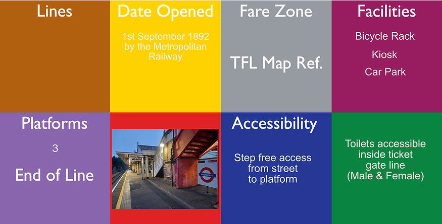
Acton Town is a London Underground station in the south-west corner of Acton. The station is served by the District and Piccadilly lines and is in Travelcard Zone 3.On the District line, it is between Chiswick Park and Ealing Common stations, and on the Piccadilly line it is between Hammersmith and Ealing Common on the Uxbridge branch. This is one of the oldest-running train stations in the world. Acton Town station was opened as Mill Hill Park on 1 July 1879 by the District Railway (DR). It remained as a terminus until on 1 May 1883 and 23 June 1903 the DR opened two branches. On the 4th July 1932 the Piccadilly services
The station is within walking distance to Acton Depot and The Acton Transport Museum. This station is a listed building.
The platforms here are open air and there is an abandoned platform here.

Addington Village Interchange is a light rail stop and associated bus station serving Addington in the London Borough of Croydon in the southern suburbs of London. It opened on 10 May 2000 along with the line to New Addington.
Platforms are open air.

Addiscombe tram stop is a light rail stop in the London Borough of Croydon. The tram stop is located between Bingham Road and Lower Addiscombe Road, and is built on the site of Bingham Road Halt on the Woodside and South Croydon Railway which was closed in 1915. The section of line follows the trackbed of the former railway which was originally on an embankment at this point and crossed over both roads on bridges. During construction of Tramlink, the embankment was removed and the bridges replaced with level crossings with the tram stop built at street level. The platforms are open air

Yes for the Metropolitan Line
4
This station near Aldgate in the City of London. The station is on the Circle line between Tower Hill and Liverpool Street, and is the eastern terminus of the Metropolitan line. It is in Travelcard Zone 1. It was opened in 1876 with its entrance on Aldgate High Street.
Aldgate East Station is a short walk away from here. On 25th September 1882, the Circle line services were introduced here.
Platforms are sub surface and partially covered and are about 7 metres below road level.

Aldgate East is a London Underground station on Whitechapel High Street in Whitechapel, in London, England. It takes its name from the City of London ward of Aldgate, the station lying to the east of the ward (and the City). It is on the Hammersmith & City line between Liverpool Street and Whitechapel, and on the District line between Tower Hill and Whitechapel, in Travelcard Zone 1.
The station is a very short walk away from Aldgate Station. The proposed name of this station before opening was "Commercial Road"
{https://thenudge.com/features/tube-facts/ The station was moved by just a few feet in 1938 in order to make the curve of the track slightly more gentle. In order to do this, the entire track had to be lowered by 2m in one night. The ground below the track was excavated during the day (with the rails held up by a wooden trestle while trains still ran over them), and 900 workmen simultaneously eased the rails down after the station closed. It reopened the next morning with no break in service} . The Hammersmith & City line appeared on the map here 30th July 1990
This station is a listed building. The platforms are about 8.2 metres underground.

All Saints is a Docklands Light Railway (DLR) station in Poplar in East London. The station is named after nearby All Saints, a Church of England parish church dating from 1821 to 1823. The station entrance is on the East India Dock Road, the high street of Poplar and is opposite Chrisp Street Market while adjacent to the Poplar Baths, it also has two rail sidings directly west of the station forming part of Poplar DLR depot. The platforms are just below street level as the tracks run under the road.

Alperton is a London Underground station on the Uxbridge branch of the Piccadilly line. The station is between Sudbury Town and Park Royal, in Travelcard Zone 4. It is located on Ealing Road (A4089 road) a short distance from the junction with Bridgewater Road (A4005) and is close to Alperton Bus Garage and the Paddington branch of the Grand Union Canal. The station was refurbished in 2006. The station was opened as Perivale-Alperton.
In 1955, an up wooden escalator was installed to the eastbound platform. It had originally been used at the South Bank exhibition of the Festival of Britain. The escalator fell out of use in 1988, and its machine remains in place behind a wall situated behind the ladies toilets. The platforms are open air.
Yes for Metropolitan Line
Amersham is a London Underground and National Rail station in Amersham in the Chiltern district of Buckinghamshire. This station is a terminus of the Metropolitan line. It is 23.7 miles (38.1 km) northwest of Charing Cross, making it the second furthest Underground station from central London and the second most westerly station of the whole London Underground system, after Chesham. It is in Travelcard Zone 9.
Amersham station is also served by Chiltern Railways, which run trains between London Marylebone and Aylesbury. The National Rail information for this station can be found here. The platforms are open air. Station layout.

Ampere Way is a tram stop in the London Borough of Croydon, serving the Purley Way commercial area. Tramlink trams serve the stop, which is located opposite IKEA Croydon.
When the stop opened, it was named "Ampere Way" in reference to the nearby former Croydon Power Station. The two chimneys from the old power station still exist in the grounds of the IKEA store. The platforms are open air.

Anerley railway station is in the London Borough of Bromley. The station is operated by London Overground, with Overground and Southern trains serving the station. It is 7 miles 47 chains (7.59 miles, 12.21 km) down the line from London Bridge, in Travelcard Zone 4.
The main building on the down side (which is only open weekday/Saturday mornings) replaced an original building (named Anerley Bridge and renamed in 1840) which was on the up platform. This was in turn replaced by two shelters on the Up platform. The platforms are open air, in a cutting and the line runs under the road. The National Rail information for this station can be found here.

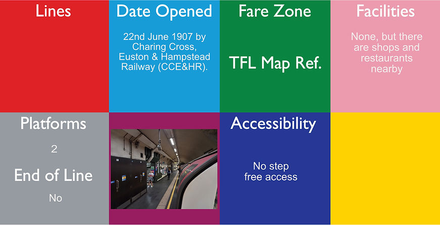
Angel is a London Underground station in the Angel area of the London Borough of Islington. It is on the Bank branch of the Northern line, between Old Street and King's Cross St. Pancras stations, in Travelcard Zone 1.The station was originally built by the City & South London Railway (C&SLR) and opened on 17 November 1901. The station served as a terminus until the line was extended to Euston on 12 May 1907.
The station was rebuilt in 1992 to accommodate the large number of passengers using the station. As a result, it has an extra-wide southbound platform, surfaced over the original 'Island' platform which had accessed both North and Southbound trains from a central landing, and features the longest escalators on the Underground network. The original entrance where the lift shaft would have been, is still visible form the road, more information can be seen at; https://www.youtube.com/watch?v=8B-uzaSO3BY. The platforms are are about 27.4 metres underground.
Archway is a London Underground station at the intersection of Holloway Road, Highgate Hill, Junction Road and Archway Road in Archway, north London, directly underneath the Vantage Point building. It is on the High Barnet branch of the Northern line, between Highgate and Tufnell Park stations, in Zones 2 and 3. It was built initially as as terminus, but now is not. The station was proposed to be called Archway Tavern before opening and has also been known as Highgate from 1907 to 1939 and then Archway (Highgate) from 1939 to 1941 and then Highgate (Archway) from 1941 to 1947, but was change to avoid confusion with Highgate. The Platforms are about 19.8 metres underground.

Arena tram stop is a light rail stop in the Woodside area of South Norwood in the London Borough of Croydon in the southern suburbs of London. The stop is located by the Croydon Sports Arena and serves the council estates of Longheath Gardens Estate and Tollgate Estate.
The tram stop is located on a section of line which follows the trackbed of the former Woodside and South Croydon Railway, although there was no station at the location prior to the opening of Tramlink. The stop is at ground level on double track, with platforms on each side of the tracks. This station (tramstop) is for Croydon football club and Croydon sports arena and residential area nearby. There are no shops or toilets nearby. The platforms are open air.

4 (facing 3 tracks)
Arnos Grove is a London Underground station located in Arnos Grove in the London Borough of Enfield, London. It is on the Piccadilly line between Bounds Green and Southgate stations and is in Travelcard Zone 4.The station opened on 19 September 1932 as the most northerly station on the first section of the Piccadilly line extension from Finsbury Park to Cockfosters. It was the terminus of the line until services were further extended to Oakwood on 13 March 1933. When travelling from east of Barons Court and through Central London, Arnos Grove is the first surface station after the long tunnel section of the Piccadilly line. The station has four platforms which face three tracks, giving the "Spanish solution" which means that a train can have doors on both sides open at the same time. It was proposed to be called Bowes Road before opening.
The station was designed by architect Charles Holden and is a listed building. The platforms are in a cutting, so are open air, but the tunnel portal can be seen from the end of the platforms at the south end.
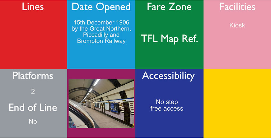
Arsenal is a London Underground station located in Highbury, London. It is on the Piccadilly line, between Holloway Road and Finsbury Park stations, in Travelcard Zone 2.Originally known as Gillespie Road, it was renamed in 1932 after Arsenal Football Club, who at the time played at the nearby Highbury Stadium. It is the only tube station named directly after a football club. Although Highbury Stadium closed in 2006, the station retains its name and is still used by spectators attending matches at Arsenal's nearby Emirates Stadium.
Unusually for a "deep level" tube station, Arsenal possesses neither escalators nor lifts. Instead, a sloping passageway leads down to the platforms, with a "tidal flow" segregation cage for football match days. Platforms are about 18.3 metres underground.
More photos can be seen at: https://tubemapper.com/arsenal-station/

Avenue Road tram stop is a light rail stop in the London Borough of Bromley in the southern suburbs of London. It is located on Avenue Road in a mainly residential area between Penge and Beckenham.
The tram stop is served by Tramlink, which connects central Croydon with Beckenham.
The tram stop is situated on a short passing loop within an otherwise single track section of Tramlink, where that system runs alongside the National Rail line between Crystal Palace and Beckenham Junction stations. The tram stop has platforms on each side of the two tracks of the loop. The National Rail line passes behind the northernmost of these platforms, but there is no platform on that line. Platforms are open air.